|
NOTES:
- Technically, the Betsie River may start northeast of Saunders Lake (southwest
of Bass Lake) in northwestern Grand Traverse County northwest of Ellis Lake and
the town of Interlochen, and WSW of Grawn.
- Officially, the Betsie River starts in Duck Lake in western central Grand Traverse
County, east of Interlochen.
- The main paddle-able portion of the river starts at Green Lake in western central
Grand Traverse County, west of Interlochen see section
1.
- Note that details are provided for the river far above Green Lake see Upper
sections A-G.
- The navigable portion from Green Lake runs generally east to west across the
southern half of Benzie County, dips briefly into northern Mansitee County in the
middle, and ends at Betsie Bay on Lake Michigan.
- Map
of Betsie River and details from the DNR This map starts at Grass Lake Dam
(ignoring the section from Green Lake) and shows the some of the rivers tributaries.
(PDF document)
- The average gradient is 5 feet per mile. On some upper portions the drop is greater.
For the initial and final few miles the drop is less.
- The total length of the river is 60 miles (from Duck Lake), but main navigable
portion is 54 miles long (about 18 to 27 hours paddle time).
- Paddle times are based on a steady paddle speed of 2.5 mph. Your paddle time
may vary based on height and speed of the river, how fast you paddle, and the boat
you're using. 2 mph is common if you don't paddle steadily, especially on longer
sections/trips. If you float a lot add at least an extra 30% to the paddle time.
- With the building of the Grass Lake Dam, the water in the Betsie River above
the dam, Grass Lake, Grass Lake Creek, Pickerel Creek, and the Twin Lakes was raised
a few feet. This makes for easy traveling but theres no solid shore on any of these
bodies of water. What might appear to be land is really a floating mat of loosely
interwoven vegetation. So plan accordingly for lunch break, rest stops, etc.
- Avoid the lower sections (Homestead Dam on down) during the thick of salmon season
(most of September) to avoid conflicts with anglers in and along the water.
- These lower, more-popular fishing sections can have more hook and line hazards
hanging from the trees than average.
- Near the end of summer, be mindful of the river's height. If there's not been
much rain, the river can be shallow allowing you to do the "knuckle walk"
a lot, especially in the upper sections.
|
| Section |
Length |
Time |
Map |
More details |
|
| Saunders Lake to Duck Lake (combination of sections A, B, C, and D below) |
3.5 miles |
|
Map of area
Map of river |
The very early portions of CREEK (RIVER)

Technically, the Betsie River may actually start northeast of Saunders Lake (southwest
of Bass Lake). Somewhere very close to, and likely just a little north of, the river's
source is the meeting area of three watersheds, those of the Boardman River, Platte
River, and Betsie River.
It's the inlet to Saunders lake that may be the actual source of the Betsie River.
After flowing through Saunders Lake, it passes through a large beaver lake, Ellis
and Tonawanda Lakes, and then empties into Duck Lake. This adds another 3.5 miles
to the length of the river, not including the 0.6 miles in Duck Lake between the
river's mouth (Tonawanda Creek) and the beginning of the next section of river which
starts at the Duck Lake Dam. |
|
| Upper Section A "Beaver" lake between
Saunders Lake and Ellis Lake |
|
|
Map of area |
THE WATER:
There is no public access to Saunders Lake. The closest one can get to that lake
(and the presumed source of the Betsie River) is to paddle to the northeast
end of the large beaver lake that's immediately to the southwest of Saunders
Lake and just north of Ellis Lake. Once at that end of the lake, you're done, as
beyond that point it's private land which includes a cleared, swampy area under large
power lines, then a private driveway over the outlet from Saunders Lake.
So how do you get to the large beaver lake? Although there is public access to Ellis
Lake (see the next section), one cannot get through its
inlet at the north it's too small, shallow, and choked with trees and brush.
But you can drive in above (north of) the inlet and put in near the south end of
the beaver lake. See details below under ACCESS.
A more adventurous trip...
This 0.7-mile-long beaver lake was created in large part by the beavers' 300-feet-long
dam at the southwestern tip, which maintains the lake's depth and makes it paddle-able.
But being a flooding, be sure watch out for the many submerged stumps, logs, dead
trees, and more!
At high-water times (2014) there's a southeastern component going through the woods
about 0.3 miles beyond the 2012 edge shown on Google Maps.
Explorers on foot Starting from the turn-around north of Ellis Lake mentioned
in the directions below, walk east. You're on the Shore-to
Shore Trail.
At 500 feet you'll come to a small, narrow bridge over the inlet to Ellis Lake.
At 700 feet you're at the southern tip of the beaver lake and the beaver
dam.
At 900 feet is a light trail angling off to the left (northeast) that goes along
the southeast side of the lake. From this point, the Shore-to Shore Trail goes southeast
and slowly curves south and connects to Ellis Lake Road it's 0.5 miles from the
turn-around to Ellis Lake Road. Or you can take the lake trail....
Walking the lake trail...
About 700 feet along is a short, swampy zone, easy to see on a satellite
view. There is some "dam"age control there another beaver dam. At
the beginning and end of winter, the ground and water are frozen enough you can get
through here without much snow to slog through. Beyond this area, you easily can
walk through the woods even though there's no trail.
At about 1200 feet long this side of the lake you'll encounter substantial wetland.
It may be barely passable at low-water times. At high-water times (2014) this is
an extension of the lake going at least 0.2 miles to southeast (and then
on to private property). Unless the lake is frozen over, you cannot walk past this
area.
There's a 0.4-mile-long previous piece of the Shore-to-Shore Trail the ends at the
lake near this wetland. See this Shore-to-Shore
Trail spur photo to get a rough idea of this single-track path. If you
spot it, you can take it south back to Ellis Lake Road. Then go 100 feet northwest
to pick up the main Shore-to-Shore Trail that goes along the east and north sides
of Ellis Lake and reconnects to the trail you started on, south of the beaver lake.
To use this Shore-to-Shore spur, it would be easier find if you start north of
Ellis Lake, walk to Ellis Lake Road, "jog" over to and follow the
spur, to the lake, then follow the edge of the lake back to north of Ellis Lake.
ACCESS:
 "Beaver" lake access carry-in
access on the west side of the southwest tip, just north of the beaver
dam. Parking for a few vehicles at the turn-around, no restroom.
"Beaver" lake access carry-in
access on the west side of the southwest tip, just north of the beaver
dam. Parking for a few vehicles at the turn-around, no restroom.
Directions: On US-31, 0.3 miles east of Rogers/Tonawanda Road and 375 feet
west of the bridge over the Ellis Lake outlet creek, there's a two-track going north.
Take that it goes on the west side of Ellis Lake and around to the "back"
(north) side of Ellis Lake. It's 0.6 miles from US-31 to a small turn-around.
Map
of two-track, with end point at the four-way intersection
Photo
of two-track, with end point at the four-way intersection
From the turn-around, walk (or drive) 175 feet north to a four-way intersection.
From there, there's a 600-foot two-track
going gently downhill east to the beaver lake and an easy carry-in access at a grassy
"cut" in the shoreline. The two-track has been used for logging and may
be hard to drive on, so it may be best to park off-road at the five-way intersection
and walk to the lake from there.
|
|
| Upper Section B Ellis Lake to Birch Road (Ellis Creek?) |
0.8 miles
Along the way, it's...
0.25 miles along the Ellis Lakeshore to the outlet.
0.4 miles to bridge at US-31.
0.7 miles to a footbridge at the old railroad crossing. |
|
Map of area
Map of trip
Photo of trip |
THE CREEK (RIVER):
A more adventurous trip...
If you don't mind paddling upriver, and having to maneuver and/or scooch over a log
or two, you might try this trip...
This short and slow section is very likely only possible in high water.
As mentioned in the last section, one cannot get through the
inlet at the north side of Ellis Lake coming from the large beaver lake it's
too small, shallow, and choked with trees and brush.
The next part of the journey begins at Ellis Lake there's a DNR access site on
the lake (see ACCESS below). You'll paddle a short way on the lake to the outlet
creek, then take it south past US-31 to Birch Road. (We've heard this creek called
Ellis Creek by some.)
From the access site, paddle along Ellis Lake's southeast shore to the outlet creek
at the southern tip. At 200 feet along is a 14-inch-tall beaver dam. At US-31 during
high-water, there's about 3 feet of clearance under the clear-span bridge and the
water is about 1.5 feet deep and 8 to 10 feet wide. However, not too long after the
bridge the creek becomes impassable the vegetation can be very dense and
there is a lot of tree-fall before coming to Birch Road.
ACCESS:
Ellis Lake DNR access Light-duty
boat launch site on Ellis Lake Road off of US-31. Parking, no restroom.
If needed, there is fair access on the south side of the US-31 bridge, on either
side of the river. No parking, no restroom.
Birch Road north access fair carry-in
access on the northwest corner. No parking, no restroom. At high-water times, the
water is 1.5 feet deep here. |
|
| Upper Section C Tonawanda Lake inlet from Birch Road to the lake |
0.2 miles
At 955 feet is the very wide (but not tall) beaver dam |
|
Map of area
Map of river
Photo of river |
THE CREEK (RIVER):
This section is very likely not worth the effort... it is very short and slow
and may be possible in high water. But... 30 feet into the trip (south of Birch Road)
is a sand bar, so you'll have to pull your boat through that, even during times of
high water. Then you may be able to pick your way through down to the 175-feet
wide beaver dam. Once there, you'll need to climb over it in the middle to connect
with the rest of the creek. The beaver dam helps maintain the creek's depth, so I
hope the locals leave it alone.
Once at Tonawanda Lake, it's 0.4 miles to the outlet (Tonawanda Creek) in the southeast
corner.
ACCESS:
Birch Road south access fair carry-in
access via the grass on the southwest corner. No parking, no restrrom. NOTE: most
of the time the water will be too shallow, and likely there will be too much over-growth,
to make the access practical.
The other, easeir way into the lake, via Tonawanda Creek, is covered in the next
section. |
|
| Upper Section D Creek from Tonawanda Lake to Duck
Lake (Tonawanda Creek?) |
0.5 miles
At 520 feet along is a beaver lodge and dam, but it's split in the center so you
can easily pass (or scooch) through. |
Round-trip, including the paddling on Duck and Tonawanda Lakes less than 2 hours. |
Map of area
Map of river |
THE CREEK (RIVER):
In western central Grand Traverse County.
The unnamed outlet creek flowing from Tonawanda Lake to Duck Lake I would guess it's
called Tonawanda Creek by some. But technically, it may be the Betsie River.
It's quite paddle-able in high water, like in the spring.
There is no public access on Tonawanda Lake, so the only way to do this creek it
to use the access at the end of Duck Lake Dam Road and paddle east then north along
the shore 0.6 miles to the mouth of the creek. Go up the creek, it's a gentle current.
Once on the creek... during the summer of 2014, at 520 feet along, there was a beaver
lodge and dam, but split in the center so one could easily pass over or scooch through.
As of the summer of 2016, others have reported a mud-and-stick wall near the start
of the creek you'll have to climb over, two more dams or build-ups along the way
you can scooch over, then another wall to climb over near Tonawanda Lake. Expect
the situation to continually change here, as the nearby residents (humans and beavers)
compete with each other.
Once at Tonawanda Lake you can explore around its shore. Check out the inlet coming
in on the north side 200 feet up you'll encounter a 175-feet-wide
beaver dam about a foot tall.
ACCESS:
Duck Lake Duck Lake Dam Road access
carry-in access at the end of the road. No parking, no restoom. |
|
| Upper Section E Duck Lake to M-137 |
1.5 miles
Along the way, it's...
0.3 miles to mouth of the river at Mud Lake.
0.6 miles to the south end of Mud Lake.where the river starts up again.
|
Round-trip to the south end of Mud Lake about an hour.
Round-trip to M-137 around 2.5 hours if conditions are favorable |
Map of area
Map of river
Photo of river |
THE RIVER:
A more adventurous trip...
If you don't mind paddling upriver, and having to maneuver and/or scooch over "a
log or two", you might try this trip. In fact, should you choose to go that
far, downstream from Mud Lake and before M-137, expect to have to get out and pull
your boat over, under, or around logs and tree-fall MANY times.
The "official" start of the Betsie River is at Duck Lake in Grand Traverse
County. (The main navigable portion starts at west side Green Lake (just west of
Duck Lake); see Section 1 below.)
The start of the river at Duck Lake is at the Duck
Lake Dam. Access at the end of Duck Lake Dam Road and paddle west 200 feet to
the dam and portage around the dam. Or, better yet, go another 200 feet farther along
the shore and there's a low, flat, 20-foot-wide isthmus to walk across to get to
the river.
In highwater, like in the spring, the water is 2 to 4 feet deep with deeper holes.
It moves along quite steadily all the way to Mud Lake, yet not so fast that you cannot
paddle back upriver from Mud Lake to Duck Lake. In this section there is almost no
treefall or obtructions. I suspect it should be easy to paddle in the summer, too.
The river beyond Mud Lake is shallower and has a significant amount of treefall and
other obstructions. Those that have paddled this say to expect to have to get out
and pull your boat over, under, or portage around logs and tree-fall MANY times.
(In fact, trying to go down Mud Lake's outlet is a fool's errand. The river becomes
rather shallow in spots with lots of logs and tree-fall to climb over, under, or
portage around. This continues for around 1.5 miles, past M-137 and past a maintenance
road bridge for the Interlochen Arts Academy (IAA). Then, about a mile above Green
Lake, the river becomes navigable again.)
There is no access along the way or at M-137, so you'll have to paddle back upriver
to Duck Lake.
ACCESS:
Duck Lake Duck Lake Dam Road access
carry-in access at the end of the road. No parking, no restoom. |
|
| Upper Section F M-137 to bridge at IAA maintenance road |
0.6 miles |
|
Map of area
Map of river
Photo of river |
There is no access at M-137, and no public access at the brdige for the maintenance
road for the Interlochen School for the Arts. The river here is shallow and has a
significant amount of treefall and other obstructions. Those that have paddled this
say to expect to have to get out and pull your boat over. under, or portage around
logs and tree-fall MANY times. So, this section cannot be recommended. |
|
| Upper Section G IAA maintenance road bridge to Green
Lake Diamond Park Road access |
1.1 miles
Along the way as you paddle upriver, it's...
400 feet to the Diamond Park Road bridge.
0.2 miles to where "Bridge Creek" joins the river.
0.7 miles to where "Betsie Creek" joins the river. |
|
Map of area
Map of river |
THE RIVER:
A more adventurous trip...
If you don't mind paddling upriver, and having to maneuver and/or scooch over a log
or two, you might try this trip...
Put in at Green Lakes Diamond Park Road access and paddle north along the shore
0.2 miles to the inlet of the Betsie River, then explore upriver.
During very high water (perhaps very early spring), the Diamond Park Road bridge
may be hard to get under. But it's do-able during "typical" spring flood
level, and easily paddled under during the summer and fall.
If the water is high and with a little luck, one can go over a mile to a bridge for
a maintenance road for the Interlochen School for the Arts. (Beyond that, the river
is too choked with treefall.) Along the way you'll encounter the creek which comes
in from Bridge Lake (aka Little Tuller Lake) we call that Bridge
Creek but it's shown on some old maps as Tuller Creek and Betsie
Creek (aka Cedar Hedge Creek, which comes in via Tullers Lake from Cedar Hedge
Lake). Explore these creeks if conditions allow.
There are a few fallen trees to maneuver around or scooch over. Expect to see many
sizes and kinds of minnows. Its a beautiful, wild area.
ACCESS:
Green Lake Diamond Park Road access
carry-in access at the road's end. Parking for just one or two cars. No restroom. |
|
| SIDE TRIP: Bridge Creek |
0.26 miles (1390 feet)
Along the way as you paddle upriver, it's 260 feet to a tiny creek coming in on the
left from an unnamed lake to the west. |
|
Map of area
Map of creek |
A more adventurous trip...
This creek has no name so we have dubbed it Bridge Creek.
If you're doing the Betsie River just above Green Lake,
(see the section above), take a short side trip and check out this little creek and
Bridge Lake. Just 0.2 miles upriver from Green Lake is where this creek joins the
river. In the spring, when the water is higher and the hedges and other shrubbery
have not encroached on the creek, you can easily paddle up this creek to get to Bridge
Lake (a nice, wild, little lake with no development).
In far western, central Grand Traverse County, southwest of Interlochen. |
|
Green Lake to the Grass Lake Dam
(combined trip of sections 1 and 2 below) |
0.5 miles in Green Lake,
4.9 miles on the river. |
2.5 hours |
Map |
See details in the sections below.
The main paddle-able portion of this river starts at Green Lake. |
|
Section 1.
Green Lake DNR Boat Launch to the Betsie River Road two-track |
0.5 miles in Green Lake,
1.8 miles on the river
Once on the river, along the way, it's...
660 feet to the Betsie River Road bridge.
1.2 miles to Hall Creek which comes in on the left (southeast) (You can go up that
creek about 0.25 miles.) |
1.1 hours |
Map |
THE RIVER:
The main paddle-able portion of this river starts at Green Lake.
Start at the public launch on Green Lake DNR boat launch (which is 0.5 mile north
of the Betsie River Bridge on Betsie River Road (on the west side of Green Lake)).
Paddle south 0.5 miles along the west shore the lake to the entrance to the river.
This is beginning of the main navigable portion of the river.
After about a half a mile past the bridge the river widens out and is very slow moving
all the way to Grass Lake Dam.
(On days with lighter winds its fairly easy to paddle upstream from the Grass Lake
Dam most of the way to Green Lake.)
ACCESS:
Green Lake DNR access Green Lake
DNR boat launch site off Betsie River Road on the west side of the lake.
Betsie River Road two-track access
very shallow gravel and sand light-duty launch on the north side of river. From
a certain 90 degree bend in Betsie River Road (at the west end of the east-west section),
go south on a flat two-track (there's a Seasonal Road sign at the entrance) 0.3
miles to the river. |
|
Section 2.
Betsie River Road two-track to the Grass Lake Dam |
3.1 miles
Along the way, it's...
2.5 miles to where Grass Lake Creek which comes in on the right..
2.7 miles to where Pickerel Creek which comes in on the left. |
1.5 hours |
Map |
THE RIVER:
You might start at the "Betsie River Road two-track" access to avoid
paddling in Green Lake.
At 0.6 miles before the end of this section, Grass Lake Creek comes in on the right
(northwest) from Grass Lake. That wide (and deep) "creek" is the only access
to Grass Lake.
At 0.4 miles before the end, Pickerel Creek enters
the river on the left (southeast) coming from the Twin
Lakes.
(On days with lighter winds its fairly easy to paddle upstream from the Grass Lake
Dam most of the way to Green Lake.)
ACCESS:
Grass Lake Dam access. The dam is in the Grass Lake Campground off of Reynolds
Road between Wallin and Cinder Roads.
Above-the-dam access theres a gravel
launch above the dam a short way on the north side of the river.
Below-the-dam access theres
carry-in access just below the dam on the north side of the river. |
|
| SIDE TRIP: Grass Lake
Creek |
1.3 miles from Grass Lake Dam to Grass Lake, 2.6 miles round trip. Add more if you
paddle around Grass Lake (with its 2 miles of shoreline). |
40 minutes paddling upriver from from Grass Lake Dam to Grass Lake. (Less on the
return trip.) |
Map |
THE TRIP:
In the southeastern area of Benzie County, south of Bendon.
Grass Lake Creek is in the southeastern area of Benzie County, south of Bendon. The
0.7-mile-long creek flows from Grass Lake to the Betsie River.
From the Grass Lake Dam, paddle upstream on the Betsie River 0.6 miles to the slow-moving,
nearly river-sized Grass Lake Creek, then upstream 0.7 miles to the 105-acre Grass
Lake.
There are lots of lily pads and other aquatic growth on the creek, but there should
be a channel to easily paddle through.
ACCESS:
Grass Lake and Grass Lake Creek access:
0.6 miles up the Betsie River from the Grass Lake Dam is the mouth of Grass Lake
Creek on the left (northwest). |
|
| SIDE TRIP: Pickerel
Creek |
4 miles round trip
Add another mile or so little more if you explore the Twin Lakes. |
Round trip: 3.5 hours
Add another half hour or so if you explore the Twin Lakes. |
Map |
THE TRIP:
In the southeastern area of Benzie County, south of Bendon.
The 2-mile-long creek flows from the Twin Lakes to the Betsie River. (And note the
1.8-mile-long Upper Pickerel Creek that flows into the southwest corner of Twin Lake.)
From the Grass Lake Dam, paddle upstream on the Betsie River 0.4 miles to the slow-moving,
nearly river-sized Pickerel Creek, then upstream about 2 miles to the Twin
Lakes, each about 16 acres. There's a 950-foot channel connecting the two lakes.
While on the creek, expect two beaver dams to skootch or climb over along the way.
There's no development; it's a nice and wild area.
As of 5/23/16, there are two beaver dams on Pickerel Creek. The first
one you'll need to get out and climb over, but getting good footing on it is
tricky. The second
one is very low in the center and you can fairly easily skootch over it. Residents
on a channel connected to the Twin Lakes have, in the past, been given permission
by the DNR to lower these dams. That lowering has occurred on the second dam, but
not the first. The height of the creek is significantly higher than past years because
of that firrst dam, at least 1.5 feet. Because of that, there were no troublesome
narrow or shallow spots as seen in the past.
This creek is best done in kayaks.
It's interesting because Twin Lake has an inlet that is Upper Pickerel Creek. That
creek's source is very close to the source of the Little Betsie River (as can be
seen here), which joins the main Betsie River
later on, between King Road and Wolf Road.
ACCESS:
Pickerel Creek access 0.4 miles up
the Betsie River from the Grass Lake Dam is the mouth to Pickerel Creek on the right
(southeast). (Hug the right shore as you go upriver.) |
|
Section 3.
Grass Lake Dam to Wallin Road (or Long Road) |
4.0 miles
Along the way, it's...
2.6 miles to the Reynolds Road bridge.
3.2 miles to an old railroad bridge.
soon after that Nostwick Road bridge.
3.7 miles to Wallin Road bridge. |
1.6 hours |
Map |
THE RIVER:
The pull-out point is 0.3 miles (7 minutes) past Wallin Road bridge.
The first two thirds of the trip (to the Reynolds Road bridge) is wider and slower.
The last third is a bit narrower and faster. (For emergencies, there is only fair
access at Reynolds Road in the northwestern corner.)
Watch out when the water is high, the Nostwick bridge can be too "low."
to get under.
Also, by the end of August, these upper sections of the river can be very shallow.
LOW BRIDGE CLEARANCE ALERT: When the water is
high (such as during the spring and/or after a long rainy period), the clearance
at the Nostwick Road bridge can be quite low; in some cases, too low to paddle
under and remain in your boat! So it is highly recommended to scout this bridge before
starting your trip. When on the water, take care to make sure you and all those with
you can make it easily under and through. There is NO easy portage here. Location:
goo.gl/maps/i13tJ
May, 2013 the right tube was clogged at the Wallin Road bridge. So check that,
too, before starting your trip.
August 30, 2014 the clogged right tube at the Wallin Road bridge has been cleared.
But always check that before starting your trip.
ACCESS:
Wallin Road access carry-in access
at the end of a 0.2-mile-long two track accessed from the southwest corner (south
side of road, west side of river).
Alternate access....
Just 975 feet downriver from the Wallin Road access is the Long Road access, so it
could be used as an alternate access point for the end of this section or the beginning
of the next section.
Long Road access carry-in
access down a few log stairs. Parking in the grass, no restroom. From the Long Road
and Wallin Road intersection, go 0.25 miles south on Long Road to access road on
left. Go 200 feet to access to river on the left.
Although this access is a little easier to get to, there's not the soft, sandy launch
that the Wallin Road access offers. You launch at the edge of the last tall stair
of a stairway made from railroad ties. |
|
| Wallin Road to King Road (combined trip of sections 4 and 5 below) |
5.2 miles |
2.1 hours |
Map |
Like many parts of the upper Betsie, early in the season these sections are fine,
maybe even a bit high. But late in the season of a dry summer these sections can
be trouble if the river is shallow -- the river is much slower and you can run aground
often. |
|
Section 4.
Wallin Road to Carmean Road |
2.4 miles
Along the way, it's...
0.4 miles to the old Long Road bridge still there are old bridge walls on the
north and south.
2.1 miles to a private access bridge. |
About an hour |
Map |
THE RIVER:
June, 2019 There is narrow, tricky spot with treefall
within the first few minutes. Expect other areas of treefall along the way.
Can be quite low in late summer.
Near the end of this section just a few minutes past the private access bridge (0.3
miles) is the Carmean Road bridge.
Carmean Road bridge as of May, 2017, the new property
owners here now deny access to the river, even in what is the road's right-of-way. |
|
| Carmean Road to Haze Road (combined trip of sections 5, 6, and 7 below) |
5.5 miles |
2.2 hours |
Map |
There are very few homes or cottages, and lots of interesting features along the
way.
Please note that there is no longer access at Carmean Road..You'll
need to start your trip at Wallin Road or King Road. |
|
Section 5.
Carmean Road to King Road |
2.8 miles
Along the way, it's...
2.2 miles to the Thompsonville Road bridge |
1.2 hours |
Map |
THE RIVER:
Can be quite low in late summer. There are very few houses or cottages along the
way.
June, 2019 No portages or branch trimming was necessary
to get through. (In the past, there was one place past the half-way point where there
was treefall completely across the river requiring a portage to get around. And there
have been a few other places where it was necessary to cut some branches to make
a pass through the treefall.)
Juine, 2019 At the Thompsonville Road bridge there are two large culverts and both
were clear.
About 15 minutes after passing under the Thompsonville Road bridge you'll be at King
Road.
ACCESS:
King Road access carry-in access
at the northeast corner.
Please note that there is no longer acess at Carmean Road.
You'll need to begin your trip to this point at Wallin Road. |
|
| King Road to Haze Road (combined trip of sections 6 and 7 below) |
2.7 miles |
1.1 hours |
Map |
|
|
Section 6.
King Road to Wolf Road |
1.5 miles
Along the way, it's...
1.0 miles to where the Little Betsie River comes in on the left.
1.3 miles to a former railroad bridge. |
0.6 hours |
Map |
THE RIVER:
One mile along the way, the Little Betsie River, coming from the east, joins
the main Betsie River here. (Although several
miles long, the Little Betsie is not large enough for any boats.)
Much of this section passes through the area of the former containment pond for the
Thompsonville power dam that was just beyond Wolf Road. Notice the tall, steep banks
of silt, sand, and soil that collected in the pond. Sharp eyes will also spot embedded
tree-fall from when the pond first flooded the area. Also present in the river are
many deadheads (old-growth logs that never made it to the mill) often stuck in the
bottom but can lurk close to the surface.
About 800 feet before the Wolf Road bridge the river passes under the former Ann
Arbor Railroad bridge which is now used by the Betsie
Valley Trail.
There's a vault toilet available at Wolf Road.
ACCESS:
Wolf Road access carry-in access
downstream (west) of bridge on the south side of the river going down the 150-foot
wooden ramp and along the 325 feet of sidewalk. (For those with kayaks, you can also
access the river by going down the short hill on the north side of the river just
west of the bridge.) |
|
Section 7.
Wolf Road to Haze Road |
1.2 miles |
0.5 hours |
Map |
THE RIVER:
A few hundred feet beyond Wolf Road bridge, there is now little evidence of the
former Thompsonville power dam but a small rapids. Built in 1903, the dam failed
in 1989 and was removed. But it helped make Thompsonville a viable concern, and maintain
the town's reputation for "the best-lit city in northern Michigan," established
in the 1890s.
This is a beautiful and wild stretch with no development, and the river is a little
deeper than in previous sections.
ACCESS:
Haze Road access carry-in access
at the southwest (or southeast) corner.
Note: There is no longer a bridge at Haze Road, so drive to it from the south
off of Lindy Road. |
|
| Haze Road bridge to Psutka (combined trip of sections 8 and 9 below) |
8.6 miles |
3.5 hours
(Expect 4.5 hours if you float most of the way.) |
Map |
|
|
| Haze Road bridge to County Line Road (combined trip of sections 8, 9, and 10 below) |
11.5 miles |
4.6 hours
This is with no stops, of course. |
Map |
|
|
Section 8.
Haze Road bridge to Kurick Road |
4.3 miles
Along the way, it's...
0.75 miles to Lindy Road.
3.2 miles to M-115 (first or east bridge). |
1.8 hours
(2.25 hours is more typical if you float most of the way.) |
Map |
THE RIVER:
There are occasional homes and cottages set back from the river along the way,
yet the area still maintains a wild character.
There is no easy entry/exit at Lindy Road or M-115.
Alert: At Kurick Road there are four large, 185-feet-long culverts. As of
6/2017, two of the four were passable, one was not, and one I could not get
to. Starting from the south. 1: passable, 2: clogged 3: passable, 4: I could not
get to.
Its highly recommended to scout these culverts before starting your
trip. The best place to check to see if the entrances to the "tubes" here
are clear is via a moderately-steep footpath at the northeast corner (of the road
and river) that goes down to tthe river. The water is normally shallow enough here
that you should be able to easily walk in to sight down the two right-hand-side tubes.
Once on the water, always look through any culvert before entering to make sure its
clear, as rubble can build up inside or just outside of the tubes. Be prepared to
portage here, if need be. You can land on the right (north) side of the river. If
you have to portage, you can exit here, go up and over the road, and re-enter the
river at the southwest corner (see just below).
ACCESS:
Kurick Road access
carry-in access at the southwest corner (just past the culverts on the immediate
left (south)). From the road there's a sandy path down a mild slope, and a sandy
and relatively shallow spot to put your boat while you enter/exit.
(Note, while it is possible to exit / enter along the river on the northwest corner,
but the bank is high and the water deep, so it's not recommended.)
Parking -- you can park south of the guardrail on the west side of the Kurick
Road. But better yet, park in the gravel/grassy
area on the northwest corner. This is DNR land! To get there, on the north side
of the river and west side of Kurick Road at Dzuibanek Road, go west just 30' and
see a two-track on the south side of the road. Pull in there and park. You can launch
from here, but as mentioned, the bank is high and the water deep, so it's not recommended.
(To get back to the nice launch spot, take the "goat paths" or better yet,
walk back the very short way on the roads.) The DNR is looking into the possibility
of putting a decent river access site here, someday. |
|
| Kurick Road to County Line (combined trip of sections 9 and 10 below) |
7.2 miles |
2.9 hours |
Map |
|
|
Section 9.
Kurick Road to Psutka Road bridge |
4.3 miles |
1.8 hours
(2.25 hours is more typical if you float most of the way.) |
Map |
THE RIVER:
There are several homes and cottages set back from the river along the first
two-thirds of this section, yet the area still maintains its wild and wooded character.
ACCESS:
Psutka Road access carry-in
access at the southeast corner. |
|
Section 10.
Psutka Road to County Line Road |
2.9 miles |
1.2 hours |
Map |
THE RIVER:
Another nice wild and wooded stretch, this time with no development.
ACCESS:
County Line Road access carry-in
access at the southeast corner.
6/2017 Update: of the two tubes (culverts) here the west one was clogged
in the entrance, and the east one was completely clear. |
|
| County Line Road to Fred's Landing (combined trip of sections 11 and 12 below) |
9.7 miles |
3.9 hours |
Map |
There's a private footbridge at Old King Road
so you know where you are as you go by. About 400 feet later Dair Creek joins the
river on the right (east). |
|
Section 11.
County Line Road to Old King Road (Off Dair Mill Road) |
6.3 miles |
2.5 hours |
Map |
THE RIVER:
A little more challenging, as there are some obstacles to go around. Not for
beginners.
August 2008 there are three log jams to climb over or portage around on this section,
There's a private footbridge at Old King Road.
LACK of ACCESS:
Old King Road end technically there may
be carry-in access at the road end, but as of June 2013 it's so over-grown it would
be very difficult. The property owners that used to allow access here are gone and
there are lots of "No Trespassing" signs on either side of the road. So
there's no good or easy access here. |
|
| Old King Road to Homestead Dam (combined trip of sections 12 and 13 below) |
6.3 miles |
2.5 hours |
Map |
|
|
Section 12.
Old King Road to Fred's Landing |
3.4 miles
Along the way, it's...
400 to where Dair Creek joins the river on the right (east).
0.7 miles to M-115 (second or west bridge). |
1.4 hours |
Map |
THE RIVER:
Only a few homes at the start, then mostly wild.
ACCESS:
Fred's Landing access Carry-in access
on west side of river. Go north from M-115 on Demerly Road 0.3 miles to Freds Landing
Road, then about 1 mile down to the river. Be sure to take a good careful look at
this location so you can spot it from the river. You may want to mark it temporarily
with a flag on a bush, or something similar. |
|
Section 13.
Fred's Landing to Homestead Dam |
2.9 miles |
1.2 hours |
Map |
THE RIVER:
The last third of this section is slower, wider, and can run shallow in some
areas.
ACCESS:
Homestead Dam access The dam is east of US-31 taking Love and Dam Roads.
Above-the-dam access carry-in access
a few hundred feet above and below the dam on the north side of the river.
Below-the-dam access carry-in
access a few hundred feet below the dam on the north side of the river. |
|
| Homestead Dam to Grace Road (combined trip of sections 14 and 15 below) |
2.8 miles |
1.1 hours |
Map |
|
|
| Homestead Dam to River Road east bridge (combined trip of sections 14, 15, and
16 below) |
4.2 miles |
1.7 hours
(or more as this is a very twisty section) |
Map |
A common trip. |
|
| Section 14. Homestead Dam to US-31 |
1.3 miles |
0.6 hours |
Map |
THE RIVER:
Since this section is just below the dam, there can be many folks fishing here
during salmon runs. A common trip is to join this and the next two sections, going
from Homestead Dam to River Road (East), making a nice two-hour paddle.
Also, during salmon runs this can be a good place to start a river trip to avoid
those fishing along the river upstream.
ACCESS:
US-31 access carry-in access is down
a 500-foot path on a hill on the north side of the river. |
|
Section 15.
US-31 to Grace Road |
1.5 miles |
0.6 hours |
Map |
THE RIVER:
In the first part of this section there are some tight turns and twists, as well
as tree-fall and logs (above and below water) to avoid that beginners will likely
find challenging. Local liveries eventually cut a path in the debris, but be careful
here early in the season, especially after a hard winter.
ACCESS:
Grace Road access carry-in access
launch at a turn-around on the east side of the river northeast of the bridge. |
|
Section 16.
Grace Road to River Road east |
1.4 miles
Along the way, it's...
1.2 miles to where Rice Creek joins the river on the left. |
0.6 hours |
Map |
THE RIVER:
Along this very pretty and twisty section Rice Creek joins the river (at 1.2
miles). The creek flows through a man-made pond thats part of a water-powered sawmill
then exits the pond via a dam with a nice waterfall
before entering the river.
ACCESS:
River Road east access carry-in access
launch next to parking lot on the east side of the river and south side of the bridge. |
|
Section 17.
River Road east (Smith) bridge to River Road west (Lewis) bridge |
3.5 miles
Along the way, it's...
1.3 miles to where the Crystal Lake Outlet joins the river on the right. |
1.5 hours |
Map |
THE RIVER:
A very popular section, good for most skill levels. There are a few nice back-water
areas. The Crystal Lake Outlet creek enters on the right (north), 1.3 miles of the
way along, as seen here. Normally, the creek
can be paddled up only a few hundred feet, but as far as M-115 is possible during
high water periods (typical in early spring).
ACCESS:
River Road west access there's a
concrete-slab launch next to the parking lot on the west side of the river north
of the bridge. |
|
Section 18.
River Road west (Lewis) bridge to Elberta Railroad bridge |
4.9 miles |
2 hours |
Map |
THE RIVER:
This section is a little wider and slower and is mostly in the Betsie River State
Game Refuge. The first two-thirds are in woods; the last third is open wetland and
the river splits into several channels. Keep to the main channel on the right.
The time shown is for floating (doing not much paddling) and with the river high
enough to get through at the end (unlike 2000 and 2001). The years 2002-2008 were
OK in a kayak. This is not a good trip on a real windy day because of the open, marshy
area for the last third of the trip..
ACCESS:
Elberta railroad bridge access carry-in
access is on the south side of the bridge and east side of the river. From River
Road, walk the 50-foot access path to the Betsie Valley Trail, turn right (west)
and follow it for 400 feet to the bridge. There are large stone stairs one can use
down to the river.
Alternate access 165 feet west of the railroad bridge along the Betsie Valley
Trail and 45 feet east of the observation deck is a short set of wooden stairs down
to the lake on the south side of the trail. Check those out as a possibly easier
place to land or launch than the stone stairs by the railroad bridge. |
|
Extension. Go a little further to the Elberta's Penfold Park
marina and boat laiuch. |
0.3 to 0.8 miles depending on route taken |
At least 15 minutes depending on route taken |
Map |
THE TRIP:
If the water level is "just right" (that is, not too high and not too
low) at Elberta, one can go under the railroad bridge then also under the M-22 car
bridge and paddle west a short ways to Elberta's Penfold Park, which is on a tiny
bay in the southwestern corner of the southern end Betsie Bay (near the main intersection
in Elberta). There are restrooms here and you can park on either side of the tiny
bay.
But the water has to not be at its lowest level, so you can paddle across the southern
section of Betsie Bay. And the water level cannot be at its highest, or you cannot
get under the M-22 car bridge.
So this very short section in only recommended if the water level is "just right".
Be sure to check out the water level before commiting to doing this section.
ACCESS:
Elberta Penfold Park access If the
water level is not too high, on the east side of the tiny bay there's a gravel and
hard-surface ramp. But during high water such as 2019, 2020, the parking lot and
the launch is under water.
Luckily, on the west side of the tiny bay is a short dock to a floating deck and
EZ Launch roller system for kayaks and canoes (which is also ADA accessible). Because
the deck and launch are floating, it should work with the lake at any of its normal
levels. |
|
|
NOTES:
- Also known as the Big Sauble River and pronounced "sauble" (saw-ble).
- The river starts in Lake County northeast of Sauble and northwest of Peacock
(which are in between Fountain and Luther). From there it makes it's way into Mason
County, running just north of Freesoil, then over through Upper and Lower Hamlin
Lakes and out to Lake Michgan.
- The main part this river is 42 miles long, and some claim 37 of those miles (from
Hamilton Road on down) are paddle-able. The U.S.F.S. says the last 29 miles are paddle-able
(from the Yonker Road / South Campbell access.) Apparenly the river is not paddled
a great deal and not served by any outfitters.
- It's said to be good river for fishing, both warm and cold-water species. "Fishing
opportunities include trout in the upper stretches and a variety of warm-water fishing
in the lower sections. Brown trout are the most prevalent species of trout with their
season running from May 1 to October 1."
- Most of the river appears to flow through forested land, some public, some private
all very scenic.
- It is a slow-moving river with a gentle current and is around 15 feet wide at
Hamilton Road to around 50 feet wide west of Quarterline Road (when not in multiple
channels and before it reaches Upper Hamlin Lake). In the spring, at least, it can
be a bit silty/muddy carrying the result of run-off.
- It's not a deep river, either. In the upper paddle-able section the average depth
appears to be 1.5 feet. (At least June 2017. Does it get much shallower later in
the summer? I would bet it does.)
- It appears the river us not cleared (or cleared often) of any tree-fall
and log jams. That's the one complaint from those that paddle it all the tree-fall
to manuever around, climb over, or portage around. Add another 25% to the paddle
time to allow for that.
- Paddle times mentioned below assume a steady paddle speed
of 2.5 mph on the river, and 2.0 mph on Upper Hamlin Lake.
- Not covered in this write-up is the last piece of the Big Sable River, 1.3 miles
so from Lower Hamlin Lake outlet to Lake Michigan. It's in the Ludington State Park,
and quite popular with tubers. It's the dam on that piece of the Big Sable River
that maintains the level of Hamlin Lake.
- For more information, see this PDF
from the U.S.F.S. and this
report at Wilder.net. This page at outdoormichigan.org
may help a little.
- NOTE: We've not paddled this river yet. It is still to
be investigated.
|
| Section |
Length |
Time |
Map |
More details |
| The whole river From "the pond" to Upper Hamlin Lake |
42.0 miles |
|
Map of entire
river trip area |
More maps:
Start of
the main river
Mouth of
the main river at Upper Hamlin Lake
Lower, final
piece of the river from Lower Hamlin Lake to Lake Michigan. |
|
Section 1.
"The pond" to 5 Mile Road, east |
800 feet |
n/a |
|
THE RIVER:
The river's just getting started no boating here!!
RIVER CROSSING:
5 Mile Road east there's no boat
access, this is just the first road crossing (culvert) over the river.
The river here is just brook about four feet wide. |
|
Section 2.
5 Mile Road, east to 5 Mile Road, west |
1.5 miles |
n/a |
|
THE RIVER:
The river pick up a lot of width and depth. It's joined by the outlet from Sauble
Lakes, so one could theoretically use a small boat here north of the road and into
the lakes. But otherwise, there's no real boating here.
RIVER CROSSING:
5 Mile Road west there's no boat
access, this is just the second road crossing (culvert) over the river.
The river is about 15 four feet wide and too shallow for boats. |
|
Section 3.
5 Mile Road, west to Hamilton Road |
3.8 miles |
n/a |
|
THE RIVER:
Not used for paddling. The river is joined by McCarthy
Creek.
ACCESS:
Hamilton Road there's carry-in access
at the northwest corner down moderately steep path, 20 feet vertical drop). Off-road
parking for a few cars. No restroom. Culvert-type bridge.
The river is an average of about 15 feet wide here and maybe 1 foot deep. |
|
Section 4.
Hamilton Road to Tyndall Road |
2.9 miles
Along the way, it's...
2.3 miles (or so) to the outlet from Pleasant Lake |
1.2 hours |
|
THE RIVER:
The river looks very shallow!!
ACCESS:
Tyndall Road there's carry-in access
in the northwest corner down a short, moderately steep, grassy hill. Shore not very
substantial. Parking off-road for a few cars at the southeast. No restroom. Platform
bridge.
The river is an average of about 20 feet wide here and maybe 1 foot deep.
Shuttle roads: Tyndall Road, Snake Trail Road, 3 Mile Road, Hamilton Road |
|
Section 5.
Tyndall Road to Yonker Road access site |
5.3 miles
Along the way, it's...
0.6 miles to where the Little Sable River joins in
1.9 miles to where the Black Creek joins in
3.1 miles to where the Muckwa Creek joins in
5.1 miles to the Yonker Road Bridge |
2.1 hours |
|
THE RIVER:
The river looks deeper here, at least later on. Before Muckwa Creek, the river
splits into two channels, with several cross-over points along the way. This goes
on for around 1200 feet.
ACCESS:
Yonker Road access site there's
easy carry-in access down 12 wooden steps at an "official" access site
1270 feet dowriver from the Yonker Road bridge. Parking for several vehicles. No
restroom.
The river is an average of about 25 feet wide here and 1 to 2 feet deep.
There is no access at the Yonker Road bridge, and no parking. It's one large culvert.
The access site is 0.2 miles south of the bridge.
Shuttle roads: Yonker Road, Sable Road, Masten Road, Manales Road. Landon
Road, Fountain Road, and Tyndall Road |
|
Section 6.
Yonker Road access site to Freesoil Road |
6.6 miles |
2.6 hours |
|
THE RIVER:
The river on this section appears to be 1 to 2 feet deep, or so.
ACCESS:
Freesoil Road there's no easy access
here, and no parking or restroom. There are two culverts.
The river is an average of about 30 feet wide here and maybe 1 to 2 feet deep.
Shuttle roads: Freesoil Road, Campbell Road, Yonker Road |
|
Section 7.
Freesoil Road to Bennett Road |
1.5 miles |
0.6 hours |
|
THE RIVER:
The river on this section appears to be 1 to 2 feet deep, or so.
ACCESS:
Bennett Road there's easy access
carry-in here, at the southwest corner down a short but moderately steep hill. Parking
for a few vehicles, No restroom. There is no bridge, just two abutments leftover
from a former bridge.. Come in from the west to get the access.
The river is an average of about 35 feet wide here and maybe 1 to 2 feet deep.
Shuttle roads: Bennett Road, Budzinsky Road, Freesoil Road |
|
Section 8.
Bennett Road to Schoenherr Road |
3.2 miles
Along the way, it's...
1.4 miles to where the river skirts Larson Road |
1.3 hours |
|
THE RIVER:
Along the way the rivers skirts by Larson Road, but there is no access from that
south section. There is also no access at the south end of the north part of Larson
Road which ends at the river.
ACCESS:
Schoenherr Road there's decent access
carry-in here at the southwest corner, 25 feet down a moderately steep path. Parking
for a few vehicles off-road at the southwest. No restroom. There are two culverts.
The river is an average of about 35 feet wide here and maybe 2 feet deep.
Shuttle roads: Schoenherr Road, Bennett Road |
|
Section 9.
Schoenherr Road to Stephens Road |
3.2 miles |
1.3 hours |
|
THE RIVER:
No comments at this time.
ACCESS:
Stephens Road there's easy access
carry-in here at the southwest corner down a 40-foot easy path. Parking for a few
vehicles off-road. No restroom. Platform bridge.
The river is an average of about 40 feet wide here and maybe 2 feet deep.
Shuttle roads: Stephens Road, Hasenbank Road, Schoenherr Road |
|
Section 10.
Stephens Road to Custer Road |
1.7 miles |
0.7 hours |
|
THE RIVER:
265 feet before the road bridge is a railroad bridge for an active railroad.
ACCESS:
Custer Road there's easy access carry-in
at the northeast corner. (If needed, there's also OK access on the south side ot
the river 130 feet before the bridge.) Plenty of off-road parking. No restroom. Platform
bridge.
The river is an average of about 40 feet wide here and maybe 2 feet deep.
Shuttle roads: Custer Road, Treml Road, Stephens Road |
|
Section 11.
Custer Road to Dar Road |
3.7 miles |
1.5 hours |
|
THE RIVER:
No comments at this time.
ACCESS:
Dar Road the best carry-in access
is at the southeast corner down a moderatly grade hill and a good launch area. There's
parking off-road for 2 cars. No restroom. Platform bridge.
The river is an average of about 45 feet wide here and maybe 2 feet deep.
Shuttle roads: Dar Road, Freesoil Road, Custer Road |
|
Section 12.
Dar Road to US-31 |
1.2 miles |
0.5 hours |
|
THE RIVER:
No comments at this time.
ACCESS:
US-31 there's easy carry-in access
and plenty of parking at the southeast corner. No restroom. Platform bridge.
The river is an average of about 45 feet wide here and maybe 2 feet deep.
Shuttle roads: US-31, Freesoil Road, Dar Road |
|
Section 13.
US-31 to LaSalle Road |
1.8 miles |
0.7
hours |
|
THE RIVER:
At 1.4 miles along, the river splits into at least two channels, but recombines
just before going under the LaSalle Road bridge..
ACCESS:
LaSalle Road there's easy carry-in
access down a short hill at the northwest corner. Off-road parking for two cars both
at the northeast and northwest. Platform bridge.
The river is an average of about 50 feet wide here and 1 to 1.5 feet deep (when it's
not in multiple channels).
Shuttle roads: LaSalle Road, Freesoil Road, US-31 |
|
Section 14.
LaSalle Road to Quarterline Road |
2.5 miles |
1.0
hours |
|
THE RIVER:
There river is often in multiple channels along this section, but recombines
just before going under the Quarterline Road bridge.
ACCESS:
Quarterline Road there's easy carry-in
access down a 50-foot path at the southwest corner, 80 feet from the bridge. Off-road
parking at all four corners. Platform bridge.
The main channel of two of more in the the river is an average of about 40
feet wide here and 1.5 feet deep.
Shuttle roads: Quarterline Road, White Road, LaSalle Road |
|
Section 15.
Quarterline Road to Upper Hamlin Lake access site |
3.3 miles |
1.3
hours |
|
THE RIVER:
There river is often in multiple channels along this section. When it's a single
channel, the river is an average of about 50 feet wide and maybe 1.5 feet deep. When
in multiple channels, the main channel is an average of about 40 feet wide
and maybe 1 foot deep.
Naturally the river gets much wider and very likely shallower befiore entering the
lake. Roughly the last 0.8 miles is in the wider area approaching or in the lake.
The river is done, so you can take out here, or at the Victory Memorial Park (see
the next section).
ACCESS:
Upper Hamlin Lake access site Gravel,
light-duty boat launch, no dock. There's a short 20-feet-wide channel in reeds out
to the lake. Parking for maybe 8 vehicles. On the north side of Upper Hamlin Lake
in the far east end. A very pretty location.
Directions: From the intersection of Nurnberg Road and Quarterline Road, take
Nurnberg Road west 2.8 miles to Forest Road 5540. (See the "Hamlin Lake Boat
Landing" sign.) Turn left (southeast) and go 0.5 miles to the boat landing.
Shuttle roads: 5540 Forest Road, Nurnberg Road, Quarterline Road
ALTERNATE ACCESS:
There is another access that
is still in the river above the lake landing above. It's on the northwest side of
an island soon before the river enters the lake area. To get there, take Nurnberg
Road 2.6 miles west from Quarterline Road to Forest Road 8039. Turn left (southeast)
and go 1.0 mile (mostly east) to a "T" intersection with another forest
road (which may be F.R. 8038 coming from the north??). Turn right and go 0.2 miles
south to a tiny turn around. Access to the river is directly to the east 60 feet
or so. |
|
Section 16.
Upper Hamlin Lake access site to Victory Memorial Park |
1.8 miles |
0.9
hours |
|
THE RIVER:
It's all lake paddling, now. Immediately cross over to the south shore and paddle
along it to the park. The lake can be as wide as 1900 feet, here. (It gets wider
if you head further west.)
ACCESS:
Victory Memorial Park Gravel, light-duty
boat launch, short dock. Plenty of parking. Township park. Pavilion, picnic table,
port-a-pottie. On the south side of Upper Hamlin Lake in the eastern third.
Shuttle roads: Victory Park Road, Fountain Road, Stiles Road, Townline Road,
Quarterline Road
WALKING TRAILS:
While you are here, take a walk on the Victory
Park Walking Trails.
- There are 0.95 miles of mostly easy trails. To do the trails as on big loop is
maybe 0.75 miles. Easily done in about halh an hour or less.
- There are a two relatvely easy hills the uphill parts of the Green and Blue
Trails.
- There are two moderatly steep portions the southern end of the Red Trail and
northern end of the Blue Trail.
- The Red Trail starts at the west side of the parking lot. The Blue Trail ends
in the middle area of the parking lot.
- Much of the way, the trails follow former two-tracks. The southern end of the
Red Trail and northern end of the Blue Trail are single-track paths.
- Starting from the parking lot, most of the Red Trail is flat and travels along
a finger of the lake. Then it curves up and around at the southern end until it's
up on a ridge.
- From the west, the Green Trail goes uphill from down by the finger, then turns
and follows the ridge.
- From the west, the Blue Ttrail goes uphill from down by the finger, then turns
and follows the ridge. It leads to a small open area at the west end is a Veteran's
Memorial near a knob in the hill. The trail continues to another knob in the hill
where there's a bench and the Hamlin Lake Overlook. From here, the trail is a single-track
path downhill to the parking lot.
|
|
|
BOARDMAN RIVER
NOTES:
- Also known as the Ottaway River or the Boardman-Ottaway River. Originally
known as the Ottaway River by Native American tribes, in the 1850s the river was
colloquially, and later officially, renamed the Boardman River. Then with the removal
of the three dams (Brown Bridge, Boardman, and Sabin, all were gone by 2018) and
the restoration the river to it original river bed, sometime around 2020 it became
referred to as the Boardman-Ottaway River.
- This river starts out many miles to the east of the navigable portion the North
Branch near Kalkaska, and the South Branch near the village of South Boardman, both
in western central Kalkaska County.
- The main paddle-able part of the river starts just below where the North and
South Branch join near Supply Road in eastern central Grand Traverse County southeast
of Traverse City, south of Williamsburg, and WNW of the village of South Boardman.
- The main navigable portion is 29.3 miles and from its starting point runs WSW,
WNW, then north through Traverse City and empties into West Bay (part of Lake Michigan's
Grand Traverse Bay).
- Average gradient: 8 feet per mile.
- Expect to move along a little faster than the average on the Betsie River, for
example 2.5 mph, at least and often closer to 3 mph (on Sections 1 through 5).
- Boardman
River details from the DNR
- Map of the complete river and all of it tributaries: map
of Boardman River
|
Back
to River List
|
|
| Section |
Length |
Time |
Map |
More details |
| North Branch Boardman River North Branch Road bridge to Forks Campground |
1.6 miles
Along the way, it's...
1.3 miles from the North Branch Road to Supply Road. |
1.5 hours |
Map |
THE RIVER:
Adventurous trip: not recommened for most paddlers.
This trip is on the North Branch Boardman River above the Upper Boardman
River. It's not very navigable and not for the "faint of heart."
There are about 15 log piles to climb-over or portage. It's a slightly smaller river
than the Upper Boardman (the next section), and very wild and scenic.
The South Branch Boardman River joins the North Branch just before the Supply Road
bridge.
ACCESS:
North Branch Road access rough carry-in
access for kayaks.
There's said to be fair access at Supply Road, but most folks use the much easier
Forks Campground access, 0.3 miles downriver.
Forks Campground access: see Section 1 below. |
|
Main Boardman River trips:
Upper Boardman
Middle Boardman
Lower Boardman sections |
Upper Boardman...
|
| Forks Campground to Brown Bridge (combined trip of sections 1 and 2 below) |
8.9 miles |
2.7 to 3.5 hours (depending on height & speed of the water and how much you paddle) |
Map
of area
Map of river |
A common trip.
Shuttle road: Brown Bridge Road. It's 15 minute shuttle time, and 6.8 miles
one-way, all on gravel.
Alternate shuttle route this should be a little faster and avoids a good
portion of gravel road from the Brown Bridge access site on Brown Bridge Road,
go west 0.4 miles to Arbutus Hills Road. Turn right (north) and go 0.5 miles to Hobbs
Highway. Turn right (east) and go 1.1 miles to Ranch Rudolph Road. Turn right (east)
and go 3.1 miles to Brown Bridge Road. Turn left (east) and go 2.9 miles to Forks
Campground. (Only the last part, on Brown Bridge Road, is gravel.) 7.0 miles total,
2.9 miles on gravel. |
|
Section 1.
Forks Campground to Shecks Campground |
4.4 miles
Along the way, it's...
2.1 miles to the stairs of the intermediate access along Brown Bridge Road..
3.2 miles to the bridge at Brown Bridge Road near Ranch Rudolph. There IS access
here at the southwest corner via a footpath down a short hill to the river,
if needed. (No parking, no restroom.)
(Also, just before this bridge, there's a platform at the river for Ranch Rudolph
guests only if needed for emergencies.) |
1.6 hours |
Map |
THE RIVER:
The main trips start here.
Generally recommended for intermediate paddlers and above.
Narrow and fast, not unlike the Upper Platte and the faster Upper Betsie portions,
but quite a bit deeper. Moderate to fairly quick current. And like most narrow rivers
in the woods, expect occassional tree-fall in, and perhaps across, the river, especially
in early spring. (The canoe/kayak liveries and others will clear a path by the summer.)
Very pretty and mostly wild. There are very few houses. There are some small hills,
tall banks, and pleasant meadows along the way,
A favored section of river for trout anglers, so be watchful for those, as well.
ACCESS:
There's said to be fair access at Supply Road, but most folks start at the easier
Forks Campground access, 0.3 miles downriver.
Forks Campground access carry-in
access on south side of river right next to the road with a handfull of off-road
parking places. Forks Campground is on Brown Bridge Road 0.3 miles west of Supply
Road, or about 10.5 miles east of (the former) Brown Bridge Dam.
Intermediate access If you want to cut this section in half, there is also
access about halfway along from Forks Campground.
Brown Bridge Road access, downriver
from Forks Campground carry-on access via a short path and a few stairs,
small parking area on the north side of the road for just two cars, no restroom.
This access site is 1.3 miles west of Forks Campground, and 1.6 miles east of where
the east end of Ranch Rudolph Road intersects with Brown Bridge Road.
Shecks Campground access carry-in
access on north side of river 400 feet east of (before) the road bridge. Shecks Campground
is on Brown Bridge Road about 4.5 miles east of (the former) Brown Bridge Dam.
Shuttle road: Brown Bridge Road.
|
|
Section 2.
Shecks Campground to Brown Bridge |
4.5 miles
Along the way, it's...
about 2.2 miles to the former Brown Bridge Pond area. |
1.6 hours |
Map |
THE RIVER:
A little more than half of this section is just like the section above, in the
woods which come to (and over) the river bank, as well as narrow, and quick.
There's one bridge right away Brown Bridge Road.
At 1.5 miles along youll pass under the Grasshopper footbridge in the east, Woodpecker
Creek section, of the Brown Bridge Quiet Area.
The last 1.8 miles is in the former Brown Bridge Pond. In 2012 the Brown Bridge Dam
was removed, the Brown Bridge Pond drained, and the river returned to its original
course. There are no woods, only the stumps of the pre-pond forest. Very slowly this
area is "coming back to life" with new lowland vegetation.
The access site is about 300 feet downriver from the former brown bridge levee,
most of which is still in place, and about 150 feet past the footbridge at the west
end of the Brown Bridge Quiet Area.
ACCESS:
Brown Bridge access about 300 downriver
from the former Brown Bridge Dam and and about 150 feet past the footbridge
at the west end of the Brown Bridge Quiet Area, there's carry-in access down the
short hill with 35 steps to a wooden platform at the river. About 35 feet to the
right of the platform is a bit of sandy shore from which its much easier to launch
kayaks. The red marker shows the initial parking area off Brown Bridge Road east
of Arbutus Hill Road and Garfield Road. There are a few parking spots there by the
road, but many more, including room for a few vehicles with trailers, 0.1 miles down
the access road. There's a restroom here (as of the summer of 2016.
Shuttle road: Brown Bridge Road. |
Middle Boardman...
|
| The Brown Bridge to Beitner Road (combined trip of sections 3 and 4 below) |
11.2 miles |
3 to 3.5 hours (depending on how much you paddle and how fast (high) the water is) |
Map of area
Map of river |
A common trip.
Easy to medium paddling, much like the faster part of the lower Betsie River. Very
little treefall, but there are a few boulders. Expect more encounters with large
boulders and sand & gravel beds when the water is low. Partially wild surroundings
and lined with handfuls of cottages. There are lot of footbridges as well as private
and public access vehicle bridges.
Shuttle road: Beitner, River, and Brown Bridge Roads. |
|
Section 3.
Brown Bridge Dam to Shumsky Road access |
6.8 miles
Along the way, it's
0.3 miles to Brown Bridge Road.
0.7 miles to Garfield Road.
2.3 miles to River Road (east).
3.3 miles to River Road (west). |
2 hours |
Map |
Intermediate access Instead of Brown Bridge, you can also start your
trip at River Road (west) where the river flows south under the road. This cuts 3.3
miles off the beginning of the trip.
River Road (west) access carry-on
access on the southeast corner, roadside parking only.
ACCESS:
Shumsky Road access carry-in access
from the parking lot on the northeast side of the river.
Shuttle roads: Shumsky Road, River Road, and Brown Bridge Road.
|
|
| Section 4. Shumsky Road access to Beitner Road |
4.4 miles |
1.3 hours |
Map |
ACCESS:
Beitner Road access carry-in access
on the east corner (upstream side of bridge, northeast side of river). There's a
wooden platform there, but kayakers may find it easier to get out in the "pool"
just past that.
Shuttle roads: Beitner Road, River Road, and Shumsky Road. |
Lower Boardman sections...
|
| Beitner Bridge to the former Sabin Dam area (combined trip of sections 5 and 6
below |
3.1 miles
(If you're interested, it's 8.7 miles from Beitner Bridge to the river's mouth at
Lake Michigan.) |
Perhaps just over an hour on the river. |
Map |
Shuttle roads: Cass Road, Keystone Road, and Beitner Road. |
|
Section 5.
Beitner Bridge to Cass Road (Robbins Bridge) |
2.6 miles
Along the way, it's...
0.5 miles is the Oleson foorbridge.
1.1 miles to the Lone Pine carry-in access on east side of river. |
|
Map of Beitner River to Oleson Bridge
Map from Oleson Bridge to Lone Pine Trail
access
Map from Lone Pine Trail access to Cass Road |
THE RIVER:
For intermediate paddlers and above. NOT for beginners.
About the rapids...
This section includes the Keystone Rapids (a.k.a. Beitner Rapids see main
rapids here), the only set of recognized rapids in the Lower Peninsula. These
are just below Beitner Bridge, feature standing waves, bushel-sized boulders, rock
gardens, tight turns, and plenty of fast water. The rapids approach a Class II rapids,
especially during high water.
From Mike
Terrell's 2008 article, we learn this half-mile stretch of whitewater
(below the Oleson foorbridge) is fairly straight forward and interspersed with rapids
and periods of calmer water, so you can line up the next set of rapids as you proceed
through each stretch.
At the site of the former Keystone Dam the river gets quite narrow and standing waves
may "deliver" some water into your boat.
2012 update the main rapids have been "watered down" either on
purpose or by nature. They are a bit tamer than they were a few years ago.
There are other rapids along this section, but supposedly not quite as intense
as the main set mentioned above.
For any rapids or any more challenging sections of a river, always scout them out
before paddling.
The sharp turn in the river just before the Oleson Bridge can be a rather tricky
affair. It's best to scout this out before doing it.
There is a sign at the Beitner Road access point and coming down to the Oleson footbridge
access site that reminds paddlers "Warning, you may encounter log jams, deep
water, and strong currnet between the Oleson Bridge and Lone Pine Landing. Use at
your own risk. For more information, contact the Grand Traverse Conservation District
at 231-941-0960 or theboardman.org."
May, 2019 Near the end of this section just before Cass Road was the former
Boardman Pond. In 2017 they removed the Boardman Dam and its Keystone Pond and have
returned the river to its original size and location on either side of Cass Road.
Upstream of Cass Road and just south of the Lone Pine Trail access is a new, small
rapids made by rocks. From there to Cass Road are occassional bushel-sized boulders.and
there may be downed trees, log jams, deep water, and swift current.
ACCESS:
Oleson footbridge access If you're
just doing the rapids, you can exit 190 feet upstream of the Oleson foorbridge (which
is 0.5 miles downstream from Beitner Road). If you are putting in here, 150 feet
downstream from that and 40 feet upstream from the bridge, on the south side of the
river, is an easy, sandy launch that avoids the rather tricky turn in the river there.
Access both of these from the Oleson Bridge Traihead
and parking lot not far away to the east.
Lone Pine Trail access At 1.1 miles
from Beitner Road is an alternate "early" end-point on the Lone Pine Trail,
just north of marker 17 on the east side of the river as seen on this
trail map. Access it from the Lone Pine trailhead
parking lot then down a 450-foot path. There's a stairway of 32 steps going down
the access site.
Cass Road access
Known as Jack's Landing, there is a carry-in access site on the east side of river.
There is a load/unload zone near the river just down from the parking lot on the
south side of Cass Road. (44.697750, -85.624139)
Shuttle roads: Cass Road, Keystone Road, and Beitner Road.
|
|
Section 6.
Cass Road (Robbins Bridge) to the Fox Den Trail access just north of the former
Sabin Dam |
1.1 miles |
|
Map
|
THE RIVER:
With the 2018 removal of the Sabin Dam and Pond, this section has been restored
to the width and location of the original river and the current is swift and steady.
There can be occasional bushel-sized boulders as well as downed trees, log jams,
and deep water. The river flows through what was a beaver pond for many years. This
section is out in the open as most of it travels through the former Sabin Pond. As
the banks and surrounding area are restored, expect some vegetation to slowly return.
Near the end of this section, at the site of the former Sabin Dam, is about 400 feet
of faster water and rapids made by large rocks. On the east side of the river, there's
is a portage area before these new (probably Class 2) "Sabin Rapids" and
a path going around them for those that choose not to do them.
ACCESS:
Now that they have removed the Sabin Dam and Pond and reworked that whole area, there
is no longer river access at the former dam site downhill from the Boardman River
Nature Center. However, if you do not mind a quarter-mile carry of your boats, there
IS access via the Fox Den Trail.
Fox Den Trail access
Park at the Nature Center, walk 500 feet down the former dam access road to the river,
then follow the trail north 800 feet (330 feet north of Post 3) to a gravel shore
where there is easy carry-in access. It's fortunate because this access site is downstream
of the new "Sabin Rapids" covered below. There are restrooms by the Nature
Center.
Shuttle road: Cass Road. |
|
Section 7.
Fox Den Trail access just north of the former Sabin Dam to the south end of Boardman
Lake |
2.0 miles
4.0 miles round trip.
Along the way, it's...
1.6 miles to the access behind tennis courts at YMCA on west side of river.
1.9 miles to the tubes at Airport Road by Logan's Landing. 300 feet later there's
a covered walkway at Logan's Landing.
2.0 miles to the south end of Boardman Lake. Medalie Park on the right (east) is
a nice rest stop. There's just no easy launch place except for the Medalie Park access
(see the "More details" section). |
Less than an hour going downstream.
Just over 2 hours round trip if you start/end at the YWCA |
Map
|
THE RIVER:
Past the short rapids of the previous section, the rest of the river is calmer
and the current relatively mild. This is a very nice woodsy section with lots of
cedar trees. Theres very little development along the way.
Note: About 0.3 miles before Airport Road and above either access site, the river
splits into two channels, both of which go under the road...
- The east channel there are a lot of dead stumps to deal with and it's
quite shallow at the north end. There is one long tube that's rather low going under
the road. Not recommended.
- The west channel is much easier. It goes
under Airport Road. The right (east) "tube" of the two is the highest.
There are two short sections of tubes here. The river goes in between the Panda North
restaurant and the former Auntie Pasta restaurant in the Logan's Landing area before
coming out into the lake.
ACCESS:
There are two Airport-Road-area access locations:
YMCA access sites. On the river, be sure to take the west channel to
access these sites. There is a kayak launch and canoe launch close together here...
Kayak access there's
an EZ-Launch kayak ramp system just east of the smaller parking lot on the north
side of the tennis / picketball courts.
Canoe access
there's a canoe launch platform southeast of the tennis / picketball courts.
Park in the southern end of the main parking lot and walk to the river on the south
side of the courts.
To get there, on the south side of Airport Road turn on Racquet Club Drive and go
past all the offices. At the southern end is a YMCA. There's a restroom by the smaller
parking lot.
Medalie Park access carry-in
access on the east side of the park in the Logan's Landing area on the north side
of South Airport Road on the south end of Boardman Lake. Restrooms.
Shuttle roads: South Airport Road and Cass Road.
|
|
| Section 8. Boardman Lake Area |
1.8 miles from the south to north end of Boardman Lake if you hug the right (east)
shore. |
Less than a hour one-way. |
Map |
THE RIVER:
On the south end of the lake, explore the river going under Airport Road and
up to Sabin Dam (see Section 7 above).
On the north end of the lake, explore the river going north under a railroad bridge,
Eighth Street, and Cass Avenue to the Union Street dam -- looks like about 0.5 miles.
ACCESS:
South Boardman Lake access See Section 7 above and the two Airport-Road-area
access locations.
If you start at the YWCA access and paddle north, you'll get go through the tubes
at Airport Road. This is not difficult, but is a bit more of a challenge when coming
back, going upriver.
A better put-in location is the Medalie Park access where there's carry-in access
on the east side of the park.
??? East Boardman Lake access: Supposedly there's
carry-in access on the east side of Boardman Lake, not too far from the south end.
Find the old YMCA building (1100 Woodmere Ave., on the west side of the road). Behind
the building there's a little path in the grass leading down a hill to the bike trail.
Apparently one can gain access to the lake there from that trail. (To
be investigated.) Not very convenient, though, even if true.
North Boardman Lake access There's
a boat launch at Hull Park next to the sailing facility. From Woodmere, take Hannah
Avenue west behind the Traverse Area District Library. |
|
| Section 9. Boardman Lake to Grand Traverse Bay (on Lake Michigan) |
1.7 miles
From footbridge at the north end of Boardman Lake it's...
180 feet to the railroad bridge.
1030 feet to Eighth Street bridge.
2450 feet to the south Cass Street bridge.
2850 feet to Union Street Dam.
3220 feet to the south Union Street bridge.
4550 feet to where Kid Creek enters the river.
4800 feet to Front Street bridge.
5000 feet to the weir.
1.1 miles to the north Union Street bridge.
1.2 miles to the north Cass Street bridge.
1.4 miles to Park Street bridge.
1.5 miles to Park Street access.
1.6 miles to Grandview Parkway (US-31/37/72) bridge.
1.7 miles to Lake Michigan. |
Less that an hour on the river -- but a portage or two is involved. |
Map |
I'm told the following, which apparently applies only to fishing:
- from the north Union Street bridge downstream to the US-31 bridge (just before
Lake Michigan) the river is closed from September 1st to October 31st. (I assume
this is for the salmon run and that the weir just upstream of the north Union Street
bridge is also closed.)
- from the north Union Street bridge upstream to the Sabin Dam the river is open
year round.
- upstream from Sabin Dam the season is from the last Saturday in April to September
30th.
North Boardman Lake access see Section 8 above for details.
From the Boardman Lake, the river goes north under a foot/bicycle bridge, an old
railroad trestle, and the Eight Street bridge. It then opens into a wide expanse
that is the backwater from the Union Street dam. After passing under the Cass Street
bridge you come to the Union Street Dam.
Union Street Dam area: there's carry-in
access but not it's not easy or paddler-friendly, as covered below...
The portage at the Union Street Dam is not an easy affair.
The take-out landing above the dam is not too difficult. There's a short section
of undeveloped land on the left (south) side of dam. But it can be muddy, and there's
a short slope not so easy when it's wet.
Launching involves more work, as there is no official launch location. The (right)
north side of the river has a walkway at the edge of the water, but it's often filled
with fishermen and not easy to access. The left (south) shore of the river is better
and more accessible from the take-out location. Take the path cut into the bank for
about a hundred feet to some stairs leading down to water. Along the edge is a stone
wall one to two feet above the water. Be watchful of any boulders in the water.
(It certainly would be nice if the city would make just a few inexpensive adjustments
to make this area more paddler friendly.)
Update February, 2020 This spring they expect
to begin work replacling the Union Street Dam and put in a FishPass systen. The dam
will be closed and they expect the work to take two years to complete. The current
take-out landing just above the dam will not be available. Instead, they will create
a new landing at Amercan Legion Park, which is above the dam on the north
side of the river just before (east of) the Cass Street bridge. Two on-street parking
spots (I assume on Washington Street) will be monopolized to create a loading zone.
Otherwise, there is no easy parking at or nearby the park. Via roads, the park is
at the southeast corner of Cass and Washington Street intersection.
The city is legally required to provide a portage option to paddlers around the dam
area. But it is unclear where one will be able to re-enter the river downstream of
the dam.
Note, also, that "river users will also have to contend with temporary river
closures when the Eighth Street and Cass Street bridges are replaced (but start dates
for those projects have not yet been finalized)."
Downstream from the Union Street Dam you go under the Union Street bridge and
there is a nice current that carries you through some neat old neighborhoods. The
view to the left (south) includes the impressive former residence of Perry Hannah,
the founder of Traverse City (TC). It is now a funeral home. As you approach the
Front Street bridge, to the left (west) is a large culvert where there is the confluence
with Kid's Creek (or Asylum Creek). This was the site of the very first mill in TC
built by Captain Boardman, the first settler of TC who sold his interest to Hannah,
who developed the area.
As you pass under the Front Street bridge there's a nice current that carries you
200 feet along to the fish weir. It should be approached with caution as there is
a good current and the weir has many narrow "slots" to which you will want
to line up with carefully your paddle must be brought inboard to fit through.
Past the weir a "concrete canyon" wall appears on the right (south) and
a riverwalk on the left (north) as you pass through downtown TC. There are several
road and foot bridges, and many places you can get out of the boat if you want to
enjoy downtown TC. The river flows slowly and gets busier with boats as you approach
the outlet into Lake Michigan's Grand Traverse Bay, but even on the busiest of days
it's not a serious issue.
Park Street / US-31 access 800 feet
past Park Street (and 600 feet before the US-31 bridge) there's a hard-surface boat
launch on the left (north) with parking. This is a good place to spot your vehicle,
and it's an easy 1 mile walk or bicycle ride using Franklin Street south to the north
access on Boardman Lake mentioned above in Section 8. (Take Park Street south to
Front Street, go east to Frankkin Street, then go south to Boardman Lake.)
Clinch Marina access The Clinch municipal
marina is 0.4 miles from the river's mouth along the beach to the west. It has an
excellent boat launch to use as a take-out. So if Grand Traverse Bay is calm, it's
worth going out into Lake Michigan and enjoy a little paddling on the "big water."
It's also an easy walk from this launch site through town back to the north access
on Boardman Lake mentioned above in Section 8.
Elmwood Marina access If you really
want some exercise, paddle west 2.7 miles from the mouth of the Boardman along the
shore of the bay to Greilickville where there's another excellent boat launch at
Elmwood Marina.
Note that about half-way along is the Apache
Trout Grill (just south of the Grand Traverse Yacht Club), which has a dock and
beach, so thirsty or hungry paddlers can enjoy a sandwich or drink with a great view
of the bay.
(Thanks to Doug S. for much of the text for this section!)
|
|
|
NOTES:
- The river starts in Wexford County at the northern side of the eastern end of
Lake Cadillac, flows NNE through the city of Cadillac, then ENE on to Missaukee County.
Once there, the river runs generally ESE to Falmouth, flows over the Falmouth Dam,
then turns to the southeast. Before entering into Clare County the river turns south.
East of Marion the river is joined by West Branh (river). Roughly two miles beyond
that, it empties into the Muskegon River.
- It appears that the upper portion (above Falmouth) of this river is not
paddled often, and there no boat liveries or outfitters. It theoretically could
be paddled as the river is wide and deep enough (at least when the river is high,
as it was during 6/2017), but it's likely not cleared by anyone of any tree-fall,
logs, or other obstructions. So expect to have to manuever around, climb over, and/or
portage around many fallen trees and the like. Do not do the upper river unless
you do not mind doing that!!
- Talking to those in the area, the river is paddled (and tubed) in the lower
river from Falmouth Dam to Stoney Corners Road. Local folks keep at least a boating
path clear in the tree-fall.
- Based on the fact that there is a DNR public access site on the river just south
of Keehn Road, folks may use boats from Stoney Corners Road down to Haskel Lake Road.
Immediately upstream from Haskel Lake Road there were trees cut with a chain saw
making a path in the river. Did they do that all of the way down Muskegon River??
This is unknown, so be prepared for tree-fall and possible log jams down from Haskel
Lake Road, at least.
- June, 2017, the lower river was quite loaded with silt. If it's like the Betsie
River, this "dies down" into the summer months.
- Even though it may be deep enough in the spring and early summer, you should
also expect the river to be quite shallow here and there, especially during a dry
summer. So be prepared to have to get out of your boat, now and then, especially
in the upper portion.
- Often the river will break into parallel channels, or have a channel break away
for a little while. See the satellite view at Google Maps to see them all and plot
your best course.
- And the river is certainly fished. It's considered a warm-water river and is
a good brook trout stream. From Seeley Road (No. 49 Road) to Turnersville Road the
river is designated a Blue Ribbon Trout Stream. Below the Falmouth Dam brown trout
are often found.
- The main river is 52 miles long. If you include the North and Middle Branch Creeks,
and the 12.5-mile-long West Branch River, together with the main river, those could
total around 100 miles.
- The river is 10 to 30 feet wide from US-131 to Seeley Road (No. 49 Road) and
0.5 to 1.5 feet deep. In Missaukee County the river picks up some springs and tributaries
and eventually deepens to 2.5 feet, on average. Below M-55 the river looses gradient
and flattens out, and can be fished by canoe. Below M-66 the river widens a bit.
For its final 10 miles in Clare County, the river widens to an average of 55 feet,
0.4 to 3 feet deep, and a slow to moderate current.
- Paddle times assume a steady paddle speed of 2.5
mph. Times will longer if the river is low, you float and do not paddle much, and
if there is any tree-fall to climb over or portage around.
- NOTE: We've not paddled this river yet. It is still to
be investigated.
- Most of these notes and the details below were taken from observations made 6/2017.
|
| Section |
Length |
Time |
Map |
More details |
| The whole river From Lake Cadillac to the Muskegon River |
52.1 miles |
|
Map of entire
river area
Rough map showing entire river |
More maps:
Start of the
river at Lake Cadillac
Intersection
where the West Branch joins in
Mouth of the
Clam River at the Muskegon River |
|
Section 1.
Lake Cadillac to Plett Road at 13th Street |
1.5 miles |
n/a |
|
THE RIVER:
The river is the
outlet for Lake Cadillac and starts going under a footbridge at the lake shore.
Just north of the "sound park" there's a small, low dam that maintains
the height of the lake. Just below the dam the water is just inches deep and 8 to
10 feet wide. Along this section, the river is more like a stream running through
(and sometimes under at Mitchell Street) the city of Cadillac in an often tree-lined,
man-made channel. (The Clam
River Greenway goes along the river much of the way.) Near the end of this section
the river is about 4" deep and 15 feet wide (late June). There's
no boating here!! The river is way too shallow with plenty of tree-fall.
ACCESS:
Plett Road at 13th there's carry-in
access at a parking lot for a sports field at the northeast corner of Plett Road
and 13th Street (No. 36 Road). One could use the footbridge (in the middle
of the northern side of the parking lot) over the river, where there's "OK"
access at the northeast corner. But better yet is from the northeast corner of the
parking lot where there's very easy access via mowed grass area. Plenty of parking,
restrooms nearby.
The river here is 15 to 20 feet wide and maybe 1 foot deep.
There also may be access at the small
bridge here, still in the sports complex, 0.1 miles downstream from the Plett
Road access. |
|
Section 2.
Plett Road at 13th Street to Plett Road by Works Avenue |
0.75 miles |
0.3 hours |
|
THE RIVER:
The river follows a man-made channel in somewhat wooded surrounding.
ACCESS:
Plett Road by Works Avenue access
relatively easy carry-in access not far from the road through the grass. Off-road
parking only, no restroom.
The river here is 15 to 20 feet wide.
Shuttle roads: Plett Road |
|
Section 3.
Plett Road by Works Avenue to Unnamed Road |
1.0 miles
Along the way, it's...
0.5 miles to US-131.
0.8 miles to Boon (No. 34) Road |
0.4 hours |
|
THE RIVER:
The river now starts to follow its original path and starts to go through patches
of woods. Along the way the river goes under US-131 (platform bridge) and Boon (No.
34) Road (tall culvert concrete bridge) there's no access at either.
ACCESS:
Unnamed Road access off of Boon (No.
34) Road access east of US-131 there's fair carry-in access at the southeast corner
down a short hill. Off-road parking. No restroom. Large concrete culvert-type bridge.
The river here is 20 feet wide and maybe 1 foot deep.
Shuttle roads: Boon (No. 34) Road, Plett Road |
|
Section 4.
Unnamed Road to Seeley (No.49) Road |
3.8 miles
Along the way, it's...
1.2 miles to a two-track bridge. |
1.5 hours |
|
THE RIVER:
This section starts out with tall grass along the banks, then becomes woodsy.
From a satellite view, it looks as if the river gets quite shallow for the last two-thirds
of this section. The river is 10 to 30 feet wide in this section, generally around
20 feet.
There's a bridge here for
unnamed two-track by Camp Cadillac, looks like a platform bridge of some type.
ACCESS:
Seeley (No.49) Road there's easy
carry-in access in the northeast corner. Off-road parking No restroom. Parking and
restroom available at the Cadillac Parhway parking lot just to the south. (Michigan
Recreational Passport required.) Culvert-type bridge: two 40" diameter tubes.
The river here is around 15 feet wide and maybe 1.5 feet deep. The banks are wooded
now, too, and stays that way for most of the rest of the river.
Shuttle roads: Seeley (No.49) Road, Boon (No. 34) Road |
|
Section 5.
Seeley (No.49) Road to LaChance Road |
2.8 miles
Along the way, it's...
1.6 miles to where Gunnerson Creek joins in
1.7 miles to where the outlet from Spring Lake joins in |
1.1 hours |
|
THE RIVER:
From a satellite view, the river continues to look quite shallow in this section. Just before being joined with Gunnerson Creek from
the north, the river splits into a few narrow (less than 10 feet wide) channels.
After the creek joins in, the river is wide (40 feet) and shallow here for 0.1 miles,
which is just before where the outlet from Spring Lake at the south joins in. Otherwise,
the river is 10 to 30 feet wide in this section, generally around 20 feet.
ACCESS:
LaChance Road (a.k.a. LaChonce)
there's just fair carry-in access in the southeast and northeast corners. Off-road
parking No restroom. Timber-truss bridge..
The river here is about 20 feet wide and maybe 1.5 feet deep.
Shuttle roads: LaChance Road, Rosted Road, Seeley (No.49) Road |
|
Section 6.
LaChance Road to Blue Road |
3.6 miles |
1.4 hours |
|
THE RIVER:
From a satellite view, the river continues to look quite shallow in this section. The river is 15 to 40 feet wide in this section, generally
around 25 feet.
ACCESS:
Blue Road there's just fair carry-in
access in the northeast corner. End of road parking for two cars. No restroom. No
bridge, abutments only. Come in from the east.
The river here is about 25 feet wide and maybe 2 feet deep. .
Shuttle roads: Blue Road, Dickerson Road, M-55 (Watergate Road), LaChance
Road |
|
Section 7.
Blue Road to M-55 (Watergate Road) |
0.8 miles |
0.3 hours |
|
THE RIVER:
From a satellite view, the river continues to look quite shallow in this section. The river is 20 to 30 feet wide in this section.
ACCESS:
M-55 (Watergate Road) there's just
fair carry-in access in the northwest corner. Off-road parking only, no restroom.
Platform bridge.
The river here is 25 feet wide and maybe 2 feet deep. To the south I saw a small-diameter
tree all the way across the river.
Shuttle roads: M-55 (Watergate Road), Dickerson Road, Blue Road |
|
Section 8.
M-55 (Watergate Road) to Clam River Park |
0.3 miles |
0.1 hours |
|
THE RIVER:
From a satellite view, the river continues to look quite shallow in this section.
ACCESS:
Clam River Park there's good carry-in
access in the northeast corner down a narrow set of stairs in the grass. There's
pretty good access at the southeast corner. Platform bridge but the road is closed
to cars. This is "old" Dickerson Road. This is part of the tiny Clam River
Park where there are two picnic tables and a port-a-pottie. There's good parking
here at the turn-around in the road.
The river here is 35 feet wide and maybe 2 feet deep.
Shuttle roads: "Old" Dickerson Road, M-55 (Watergate Road) |
|
Section 9.
Clam River Park to M-66 (Morey Road) |
4.6 miles
Along the way, it's...
2.6 miles to a footbridge
3.8 miles to another footbridge |
1.8 hours |
|
THE RIVER:
From a satellite view, the river continues to look quite shallow in this section,
with several bits of tree-fall.. The river is 15 to 40 feet wide in this section,
generally around 25 feet.
ACCESS:
M-66 (Morey Road) there's reasonably
good carry-in access in the northeast and southeast corners, and fair access at the
northwest. Low platform bridge but clearance looks OK. Off-road parking, no restroom.
The river here is an average of about 25 feet wide and maybe 2 feet deep.
Shuttle roads: M-66 (Morey Road), M-55 (Watergate Road), "Old" Dickerson
Road |
|
Section 10.
M-66 (Morey Road) to Call Road |
1.9 miles
Along the way, it's...
0.4 miles to where Stick Creek enters from the southwest |
0.8 hours |
|
THE RIVER:
From a satellite view, the river continues to look quite shallow in this section.
The river is 20 to 45 feet wide in this section, generally around 28 feet.
ACCESS:
Call Road there's reasonably good
carry-in access in the northeast corner, all other corners are marked private property..Patform
bridge. Off-road parking at northeast corner, no restroom.
The river here is about 25 feet wide and maybe 2 feet deep.
Shuttle roads: M-66 (Morey Road), M-55 (Watergate Road), "Old" Dickerson
Road |
|
Section 11.
Call Road to Falmouth Road |
0.8 miles |
0.3 hours |
|
THE RIVER:
From a satellite view, the river continues to look quite shallow in this section.
The river is 24 to 38 feet wide in this section, generally around 30 feet.
ACCESS:
Falmouth Road there's easy carry-in
access at the northwest corner. Off-road parking, no restroom. The very slow-moving
Marks Creek from the south joins the river on the north side of the patform bridge
over the creek which is too low to get under unless the water is very low. But
there's need to go under the bridge.
Shuttle roads: Falmouth Road, M-66 (Morey Road) |
|
Section 12.
Falmouth Road to Vander Meullen Road |
4.6 miles
Along the way, it's...
2.7 miles to where Taylor Creek enters from the north |
1.8 hours |
|
THE RIVER:
From a satellite view, the river continues to look quite shallow in this section.
For the first half of this section, the river is 25 to 55 feet wide, generally around
35 feet. Then about half way along, Taylor Creek joins in, and the river becomes
much wider, going as wide as 250!! Then it slowly tapers back down to it's "normal"
width (35 feet) but a little deeper (than upstream of the Taylor Creek mouth)..
ACCESS:
Vander Meullen Road there's only
just fair carry-in access at best at the NE. SE, anmd SW corners, and poor at the
NW.. At the southwest, 150 feet or so south of the bridge is Cadillac Road. Take
that just 100 west to a two-track that goes down to the river for reasonably good
carry-in access. That may be private land, so ask permission, first. Patform bridge.
Off-road parking, no restroom
The river here is 35 feet wide and maybe 2.5 feet deep.
Shuttle roads: Vander Meullen Road, Falmouth Road |
|
Section 13.
Vander Meullen Road to Turnersville Road |
2.0 miles
Along the way, it's...
0.6 miles to where Mosquito Creek enters from the north |
0.8 hours |
|
THE RIVER:
The river looks "normal".
ACCESS:
Turnersville Road there's only just
fair carry-in access on the south side of the river. From the the end of the gravel
road walk north down a two-track then through light brush to the river. There's no
bridge, and no access from the north. Parking for two cars at the end of the gravel
road, no restroom.
The river here is an average of about 40 feet wide and maybe 2.5 feet deep.
Shuttle roads: Turnersville Road, Falmouth Road, Vander Meullen Road |
|
Section 14.
Turnersville Road to Forward Road |
1.7 miles |
0.7 hours |
|
THE RIVER:
For most of this section, the river is 30 to 80 feet wide, generally around 45
feet. Then about 0.3 miles before Forward Road, the river widens out (70 to 190 feet)
as it gets close to the Falmouth containment pond that's on the east side of the
Forward Road bridge.
ACCESS:
Forward Road there's easy carry-in
access at the southwest corner. There's parking there, too, but no restroom. Platform
bridge. There's a footbridge on the east side of the road bridge, but the brush is
very overgrown at the ends.
The river here is maybe 100 feet wide just west of the bridge and roughly 2.5 feet
deep at the bridge
Shuttle roads: Forward Road, Falmouth Road, Turnersville Road |
|
Section 15.
Forward Road to the Falmouth containment pond boat launch |
0.3 miles |
8 minutes |
|
THE RIVER:
The river flows through the 12-acre Falmouth
containment pond. This section is all in the pond.
ACCESS:
Falmouth Pond, River Street access above and below the dam via the park next to
the dam at the west end of the River Street. There's parking, but no restroom.
- Boat launch on the pond there's
a light-duty, gravel launch right off of the parknig lot for the park. (Apparently
the launch is not used often as there's a huge rut in the gravel, 6/2017)
- River access below the dam there's
carry-in access via a path off of the southwestern corner of the parknig lot for
the park. There are three paths, take the one on the left (southern-most) down a
moderately steep hill.
Shuttle roads: River Street, Main Street, Proper Road, Forward Road
|
|
Section 16.
Falmouth containment pond to 7 Mile Road |
4.2 miles |
1.7 hours |
|
THE RIVER:
The river is 30 to 70 feet wide in this section, generally around 45 feet.
ACCESS:
7 Mile Road there's easy carry-in
access at the northeast corner, and good carry-in access at the southwest corner.
There's parking in the grass off the road at the southwest corner; no restroom. Platform
bridge. A popular access site during the height of the summer. Locals keep the grass
here mowed.
The river here is roughly 2 feet deep.
Shuttle roads: 7 Mile Road, Falmouth Road, Main Street, River Street |
|
Section 17.
7 Mile Road to 8 Mile Road |
1.7 miles |
0.7 hours |
|
THE RIVER:
The river is 40 to 70 feet wide in this section, and 25 feet wide when in channels.
ACCESS:
8 Mile Road there's reasonable carry-in
access at the northeast corner. Off-road parking; no restroom. Platform bridge. Not
a common access site.
The river here is roughly 2 feet deep.
Shuttle roads: 8 Mile Road, Stoney Corners Road, 7 Mile Road |
|
Section 18.
8 Mile Road to Stoney Corners Road |
2.3 miles
Along the way, it's...
0.9 miles to a footbridge
1.1 miles to a what looks like row of several rocks (or submerged log) across the
water
1.6 miles to a footbridge |
0.9 hours |
|
THE RIVER:
The river is 35 to 70 feet wide in this section, and some riffles seen along
the way.
ACCESS:
Stoney Corners Mile Road there's
decent carry-in access down a five-foot grassy slope at the southeast corner. Parking
in a grassy clearing at the southeast corner; no restroom. Platform bridge. A common
access site.
The river here is roughly 2 feet deep.
Shuttle roads: Stoney Corners Road, 8 Mile Road |
|
Section 19.
Stoney Corners Road to Keehn Road |
5.0 miles
Along the way, it's...
2.2 miles to a footbridge |
2.0 hours |
|
THE RIVER:
The river is 45 to 90 feet wide in this section, and 30 feet wide when in channels.
ACCESS:
Keehn Road there's decent carry-in
access at the southwest corner. Off-road parking; no restroom. Platform bridge.
The river here is roughly 2 feet deep with a decent, moderate current (6/2017).
Shuttle roads: Keehn Road, Strawberry Avenee, Richards Road, Streif Road,
9 Mile Road, Stoney Corners Road |
|
Section 20.
Keehn Road to DNR Access Site |
0.1 miles |
3 minutes |
|
THE RIVER:
No comments.
ACCESS:
DNR Access Site there's a light-duty
gravel launch. Parking for a handful of vehicles; no restroom. From 11377 Strawberry
Avenue, on the east side of the road, take a two-track 600 feet to the river.
Shuttle roads: Keehn Road, Strawberry Avenue, Richards Road, Streif Road,
9 Mile Road, Stoney Corners Road |
|
Section 21.
DNR Access Site to Haskel Lake Road |
4.6 miles |
1.9 hours |
|
THE RIVER:
The river is 30 to 90 feet wide in this section, generally around 55 feet.
ACCESS:
Haskel Lake Road there's decent carry-in
access at the southeast corner. Off-road parking east of the bridge; no restroom.
Platform bridge.
The river here is roughly 2 feet deep.
Shuttle roads: Haskel Lake Road, Cook Avenue, Pierce Road, Strawberry Avenee,
access site two-track |
|
Section 22.
Haskel Lake Road to Pine Road access on Muskegon River |
4.8 miles
(3.7 on the Clam, 0.9 miles on the Muskegon)
Along the way, it's...
0.3 miles to where the West Branch comes in fom the west.
3.7 miles to where the Clam River joins the Muskegon River |
1.9 hours |
|
THE RIVER:
The 12-5-mile-long West Branch (of the Clam River) joins in from the west
0.3 miles downstream from Haskel Lake Road at this intersection.
Its created by the merging of the Middle Branch and North Branch Creeks, 6.91 miles
as the crow flies to the northwest. Looking at the last few miles of that river during
June, 2017, it was quite muddy, about 20 feet wide, and maybe two feet deep. Very
likely it will be lower as the summer progresses, and become less muddy. Looking
upstream from where it joins the Clam River, there was no decent access to this river
at Cook Avenue (at which there were two large culverts) or at Partridge Road (platform
bridge). On Haskel Lake Road (1.5 miles west of Cook Avenue) there was only fair
access at all corners (also a platform bridge). It's very likely not paddled.
The Clam River is 55 to 90 feet wide in this section.
The 52.1-mile-long Clam River ends where it empties into the upper Muskegon
River at this intersection.
The nearest river access is not far along downstream, just 1.1 miles down the Muskegon
at Pine Road. During this section, the Muskegon River is 90 to 150 feet wide. It's
also rather slow and muddy.
ACCESS:
Pine Road access on Muskegon River
there's easy carry-in access at the southwest corner. (If needed, there's reasonable
carry-in access at the southeast corner.) There's parking for a few cars at the southwest
corner. No restroom. Platform bridge.
Shuttle roads: Pine Road, Cook Avenue, Haskel Lake Road |
|
|
NOTES:
- The Hersey River is all in Osceola County. It starts north of Reed City on the
west side of US-131 specifically, where Hersey Creek and the East Branch Hersey
Creek join together just south of Penasha Road (9 Mile Road) and in between 220th
and 225th Avenues. From there it flows south, goes under US-131 just south of 7 Mile
Road, and is joined by several creeks before entering the Lake No Slo Mo impoundment
next to the south end of the Nartron Field airstrip. At the south end of the lake
is a dam. From there the river runs south, goes under US-10, then turns to the southeast,
flows through Reed City, then a little later through Hersey before joining with the
Muskegon River.
- The Hersey Dam was located 0.7 miles from the Hersey River mouth to the Muskegon
River but it blocked fish from proceeding further upstream and was removed in 2007.
The rational for the removal of the dam is that it will reconnect the Hersey River
and Muskegon River and allow trout a thermal refuge from the Muskegon River mainstream
during warm summer months.
- The river is 21 miles long and has an average gradient of 11.8 feet per mile
over the enitre river. (That's pretty fast. The average gradient of the Lower
Platte is 3 feet per miles, the Betsie is 5 feet per mile, the Boardman is 8 feet
per mile, the Pine is 10 feet per mile, and Upper Platte is 13 feet per mile.) However,
for 8.3-mile paddle-able portion, from below Lake No Slo Mo to the Muskegon River,
the gradient is 7 feet per mile, which is more moderate it's between the
Betsie and the Boardman. A relatively mild current.
- At least from the Lake No Slo Mo impoundment the river appears to not change
width very much.
- This small and scenic river is a designated high-quality coldwater stream and
trout stream.
- There are a few canoe/kayak liveries in Hersey, but these appear to service only
the nearby Muskegon River.
- Tree clearing cutting just enough space to paddle through none was seen from
Lake No Slo Mo to US-10, there was some between US-10 and White Pine Trail, and for
sure tree cutting was happening below White Pine Trail.
- The only official access to the river was found in Westerburg Park in Reed City.
- It appears this river is not paddled often, perhaps because of the tree-fall
and the more popular, wider, and much-more-clear-of-tree-fall Muskegon River that's
nearby at Hersey.
- Based on a report from 2021, the river is for sure paddle-able from just below
dam on Lake No Slo Mo to the Muskegon River, but expect some tree-fall to climb over
(at least three times) and lots of rapids (besides the Roth
Street Rapids) during lower water times.
- We've not paddled this river yet. It is still to be investigated.
|
| Section |
Length |
Time |
Map |
More details |
| The whole river |
21 miles |
|
Map of area for the entire river |
|
|
| The lower river from just below Lake No Slo Mo to the Muskegon River |
8.3 miles |
3.5 to 4 hours depending on the height of the river and how much tree-fall you have
to climb over. |
Map of area of of just the lower river |
If this river is paddled it's most likely done below the lake, as above the lake
the river is too narrow, too shallow, and/or containing too much tree-fall. So we
cover just the lower river starting at the south end of Lake No Slo Mo (just below
the dam) to the Muskegon River.
Here is a very nice, 50-minute
video from fellow paddler Scott and his trip 7/19/2021 from just below Lake No
Slo Mo to the Muskegon River. (Thank you, Scott!) It provides a great idea of what
to expect.
NOTE: Watch out for 10-15 artificial (man-nade) breaks (very low dams) put
in the river made using concrete, rocks, stones, and possibly metal to hold back
the river a key points. These are perhaps to create swimming or fishing areas, or
keep bank erosion down. These areas are maybe three feet deep. But the "walls"
themselves are just inches below the surface and can be troublesome during low water
times. |
|
Section 1.
Lake No Slo Mo to Rembrandt Park |
0.7 miles
(8.3 miles to the end)
Along the way, it's:
0.6 miles to platform bridge at US-10
another 150' to a footbridge |
Maybe 21 minutes ignoring any log jams or tree-fall |
Map of section |
THE LAKE:
If you want to explore the 25-acre Lake No Slo Mo there is easy access here:
Lake No Slo Mo access easy carry-in
access to the northeast from the turn-around at the east end of Aztec Avenue. Parking,
no restroom.
THE RIVER:
To paddle the river, put in just below the dam at the southeast corner of the
lake. From the turn-around at the east end of Aztec Avenue, walk 400 feet to the
dam and about 50' below it to river.
Below the Lake No Slo Mo dam river access
reasonable carry-in access on the west side of the river just below the dam. East
of the turn-around at the east end of Aztec Avenue. Parking, no restroom.
This is a very short section. Expect some tree-fall along the way. In fact, in
2021 there were two logjams of tree-fall that required climbing over. The river's
width is usually 35 to 50 feet.
NOTE: Because of the lack of dedicated boat access at either end and especially
because of the logs piled up at the old railroad / White Pine Trail bridge just east
of Chestnut Street (Old US-131), this section is likely rarely paddled. Instead,
folks start at the dedicated boat access at Westerburg Park see Section
3.
ACCESS:
Rembrandt Park access fair carry-in
access on the east side of the river about 250 west of the little parking area on
Old US-131 that's just south of US-10. Once at the river, look up and down along
it a little ways to find the best access spot. Parking, there may be a restroom nearby.
|
|
Section 2.
Rembrandt Park to Westerburg Park |
0.6 miles
(7.6 miles to the end)
Along the way, it's...
0.3 miles to the platform bridge for Chestnut Street (Old US-131)
another 140' to the old railroad / White Pine Trail bridge |
Maybe 18 minutes ignoring any log jams or tree-fall |
Map of section |
THE RIVER:
Another a very short section. Expect a little tree-fall along the way. At the old
railroad / White Pine Trail bridge just east of Chestnut Street (Old US-131) there
are logs held in place across the river that catch a lot of other debris. There is
a train car chassis lodged in the wooden support areas on the left side of the river,
as well. In October of 2017, these logs could be easily scooched over in a kayak.
In 2021 they had to be climbed over. I suspect many paddlers will not like to do
that.
There is an actual train car chassis lodged in the wooden support areas on the left
side of the river.
The river's width is usually 35 to 50 feet.
NOTE: Because of the lack of dedicated boat access to the start of this section
and especially because of the logs piled up at the old railroad / White Pine Trail
bridge just east of Chestnut Street (Old US-131), this section is likely rarely paddled.
Instead, folks start at the dedicated boat access at Westerburg Park see Section
3.
ACCESS:
There is no decent acesss at Chestnut Street (Old US-131). But there is good access
at the east end of Westerburg Park.
Westerburg Park
access reasonable carry-in access down a 250-feet-long path from Elm Street
that runs through the park. Parking; restrooms nearby.
Shuttle roads: Elm Street, Mackinaw Trail, Old US-131. |
|
Section 3.
Westerburg Park to Church Street |
1.1 miles
(7.0 miles to the end)
Along the way, it's...
0.2 miles to Rohn Street (210th Avenue)
another 220' to the start of the "Roth Street Rapids"
another 140' to the end of the "Roth Street Rapids"
0.6 miles to Pere Marquette Trail bridge (likely culverts)
0.8 miles to a small bridge perhaps for a pipeline |
30 minutes or less |
Map of section |
THE RIVER:
This section includes the "Roth Street
Rapids" just east of Roth Street. These are Class 2 and should not be
done by those new to paddling. Also, you should scout these rapids from then
nearby "electric yard" whose access road is just south of the Roth Street
bridge on the east side of the street. Expect the current to be much faster in the
rapids, of course.
Expect a little tree-fall along the way. The river appears to be about 2 to 3 feet
deep. The river's width is usually 30 to 50 feet. Just before the rapids it gets
much narrower and likely deeper.
ACCESS:
There is no decent acesss at Roth Street. But there is reasonable access at Church
Street.
Church Street access decent carry-in
access down a short grassy path at the northwest corner. No parking or restroom.
Platform bridge.
Shuttle roads: Church Street, US-10, Roth Street, and Elm Street. |
|
Section 4.
Church Street to Diamond Road (200th Avenue) |
1.1 miles
(5.9 miles to the end)
Along the way, it's...
0.5 miles to the bridge at Craft Road |
30 minutes or less |
Map of section |
THE RIVER:
Start with this section if you wish to avoid the Roth Street Rapids.
Expect little to no tree-fall along the way. But there are several areas of riffles,
and occasional small rock dams across the river followed by riffles. The river appears
to be about 2 to 3 feet deep. The river's width is usually 35 to 65 feet.
ACCESS:
There is no decent acesss at Craft Road. But there is acceptable access at Diamond
Road (200th Avenue)
Diamond Road (200th Avenue) access
acceptable carry-in access at the southeast and southwest corners. There are stone
steps down to the river at the southeast corner. No parking or restroom. Platform
bridge.
Shuttle roads: Diamond Road (200th Avenue), Craft Road (Dunham Avenue), Ann
Street, and Church Street. |
|
Section 5.
Diamond Road (200th Avenue) to Lincoln Road (190th Avenue) |
1.4 miles
(4.8 miles to the end)
Along the way, it's...
0.4 miles to a light-duty bridge of some sort
0.8 miles to Pere Marquette Trail bridge (looks like a platform or post bridge) |
40 minutes or less |
Map of section |
THE RIVER:
Expect little to no tree-fall along the way. But there are several areas of riffles,
and the river gets wider and shallower in spots, as well. The river's width is between
30 to 90 feet. The river appears to be get to be 3 to 4 feet deep by Lincoln Road
bridge.
ACCESS:
Lincoln Road (190th Avenue) access
easy carry-in access via a short grassy path at the northwest corner. Roadside
parking only, no restroom. Large concrete culvert bridge.
Shuttle roads: Lincoln Road (190th Avenue), US-10, and Diamond Road (200th
Avenue) |
|
Section 6.
Lincoln Road (190th Avenue) to Main Street in Hersey |
2.3 miles
(3.4 miles to the end)
Along the way, it's...
0.4 miles to Pere Marquette Trail bridge (looks like a platform or post bridge)
0.6 miles to a footbridge |
1.1 hours or less |
Map of section |
THE RIVER:
Expect little to no tree-fall along the way. There may be a few riffles and shallow
areas. The river's width is between 25 to 60 feet. The river appears to be only 2
feet deep by Main Street. (A local waitress said a lot of folks start at Lincoln
Road then float down to the Muskegaon River.)
ACCESS:
Main Street access decent carry-in
access at the southeast corner at the tiny Hersey Village East Park. Parking and
port-a-pottie. Platform bridge.
Shuttle roads: Main Street, 180th Avenie, US-10, and Lincoln Road (190th Avenue) |
|
Section 7.
Main Street to Hersey Road (4th Street) access on the Muskegon River |
1.1 miles
Along the way, it's...
1.0 miles to Blodgett Landing
another 240' to the Muskegon River
another 200' to the Hersey Road (4th Street) Muskegon River access site |
30 minutes or less |
Map of section |
THE RIVER:
Expect little to no tree-fall along the way. But there are some areas of riffles.
The river's width is usually 30 to 55 feet. At Blodgett Landing, the river appears
to be about 2 feet deep.
ACCESS:
Just before getting to the Muskegon River, one could get out at Blodgett
Landing, a public campground on the river with a T-dock and acceptable carry-in
access. There's parking and a restroom nearby. But go another 440 feet and one can
use the easier and very nearby Hersey Road (4th Street) Muskegon River access...
Hersey Road (4th Street) Muskegon River
access light-duty gravel boat launch at the northwest corner of Hersey Road
and the Muskegon River. Parking and port-a-pottie. Platform bridge.
Shuttle roads: Hersey Road (4th Street) and Main Street. |
|
|
NOTES:
- The Little Manistee is a National Wild and Scenic Study River.
- The river starts in eastern central Lake County, a few miles southeast of Luther.
It flows west to M-37, then northwest, cuts across the northeastern corner of Mason
County, then runs through the southwestern corner of Manistee County.
- It may be called "little" but this river is 67 miles long. The paddle-able
portion is 41 miles long, though most folks will only want to paddle the last 7.8
miles (ESE of Stronach).
- This is a cooler, spring-fed river.
- Gradient:
- Indian Bridge to 9 Mile Bridge 6 feet per mile.
- 9 Mile Bridge (Skocelas Road) to Six Mile Bridge 14 feet per mile (faster than
the averages for the Pine or the Upper Platte!)
- 6 Mile Bridge to Old Stronach Bridge 4 feet per mile.
- Although a popular trout stream, this river does not see anywhere near the amount
of paddling traffic that other nearby rivers (such as the Pine, Pere Marquette, and
big Manistee) receive.
- Avoid the lower section during the thick of Salmon season (most of September
and some of October) to avoid conflicts and hook hazards with anglers.
- For the upper sections and especially middle section, the total trip time will
be significantly more than the estimated paddle time given due to all the tree-fall
and other obstructions to deal with and/or portage around. It's best to assume they
are not regularly maintained for paddling, so expect lots of tree-fall and other
hazards
- For ALL sections, regardless of your skill level, always investigate the current
conditions ahead of time before committing yourself.
- A caution from Paddling.net
about the Old Grade to 6 Mile portions (and seen between then 6 Mile Bridge and the
weir, as well) "One word of caution about this river, it seems that this river
was used for logging earlier in it's history. There are many places where the old
logging flume posts are still in place. Some extend out of the water and some are
under it's surface. Most of these are 2-3" diameter logs driven into
the river bed. They can be challenging to notice until you are right on them
and the current will easily push you up onto them. Getting off them can be little
tricky. But the bigger problem is the old spike nails in some of them. I put
a very deep 8" scratch in my hull on day one that went almost all the way through.
After that I made sure to steer clear of these old logging flumes." Note that
those exposed nail heads can tear right through a plastic boat.
- Little Manistee Watershed Conservation Council
Web site
- Map
from the USDA showing the river and many campsites from the Driftwood Valley
access west to Manistee Lake
|
|
I divide the river into four portions...
I. The upper-most reaches...
At the Old
Grade National Forest campground on M-37 a few miles north of Wolf Lake
on the north side of the river and west side of the highway, just north of 4 1/2
Mile Road (Google Map of site), there is no
official access. But one can get to the river perhaps from some camp sites, and for
sure via a short walk in the woods from the loop in the road at the west end. There's
a small "Overflow Parking Lot" for maybe four cars just before the camping
area where you could park. During highwater in the spring, the river can be 50 to
70 feet wide and a few feet deep. But normally, the width and depth is closer to
half of that, and like the USDA page says, "Canoeing is not recommended on this
portion of the river as it is very shallow. However, this area is popular with angkers
seeking trout."
There is also access at Spencer Bridge on Peacock Trail just north of 5 Mile
Road (Google Map of site). There are a few
steps to the river, a small parking area, and a restroom at a DNR fishing access
site. During highwater in the spring, the river can be 25 feet wide and a four feet
deep. But normally, the width and depth is closer to two-thirds of that. The over-growth
in spring is present but not nearly as abundant as it is during the summer.
Although there is access "up here," the river this far up is very small,
often quite choked by fallen trees, and at points, lots of over-growth so it's
not easily navigable and not covered below. From Paddling.net
this section is NOT for first time kayaker/canoers. The river is always running
fast and you never know what is around the curve. It could definitely be dangerous.
Even intermediate paddlers will have trouble fighting the current and getting through
the 4-foot path occassionly cut through the deadfall.
II. Upper Sections 1, 2, and 3...
More needs to be learned about the three upper sections above 9 Mile Bridge.
But it seems very safe to say, these sections are not recommeded for beginners. Compared
to the very challenging Middle Section, these sections have
tamer water. But they also have many tight bends and lots of tree-fall and other
obstructions to go over and around. The river is also narrow and normally quite shallow,
and can be high in the spring making everything trickier. The details are below.
III. Middle Section...
Those looking for very challenging experience will enjoy the Middle
Section. Recommended for advanced and adventurous paddlers
only.
IV. Lower Section...
Those looking for an easier experience will enjoy the Lower
Section.
|
|
| Section |
Length |
Time |
Map |
More details |
Upper section 1
Indian Bridge (Irons Road) to the the Fox Bridge (Bass Lake Road) |
8.8 miles
Along the way, it's...
3.3 miles to Johnson Bridge (Johnson Road).
7.6 miles to Dewitts Bridge (Granger Road). |
3 hours (paddle time) |
Map of area
Map of river |
THE RIVER:
Some claim you can start a paddle trip as high as Indian Bridge (and some
even say M-37), but the river is quite narrow, shallow, with many tight
turns and numerous logjams and fallen trees to go over or around. High water in early
spring can make some sharp bends challenging for novices. And there can be trees
and shrubs overhanging the river. Also expect many areas of fast water and long riffles.
Not recommeded for beginners.
Be sure to see the NOTES above about this river.
ACCESS:
Indian Bridge (Iron Road) access
carry-in access at the northeast corner at any of several sets of short stairways,
parking, restroom. DNR access site. (South of Irons, on Irons Road at the northeast
corner.)
There are two intermediate access points along the way, but very likely neither
will be needed:
Johnson Bridge (Johnson Road) access
carry-in access down a short path and an easy bank and shallow river edge right
off the road at the southwest corner. Very limited roadside parking. (On Johnson
Road south of Irons.)
Dewitts Bridge (Granger Road) access
there is only fair carry-in access down a four-foot grassy slope from the east
edge of the road to the river. Limited roadside parking only. (Granger Road just
north of River Road.)
Fox Bridge (Bass Lake Road) access
carry-in access down a wide 100-foot path, very small parking area, no restroom.
Fox Bridge is sometimes called the "10 Mile NE Bridge." (On Bass Lake Road
(CR 669) on the southeast corner.)
|
|
Upper section 2
Fox Bridge (Bass Lake Road) to Bear Track Campground access |
6.1 miles
Along the way, it's...
1.7 miles to Poggensee Bridge (aka Pole Brdge) at 10 Mile Road (aka Mitchell Road).
2.2 miles to Driftwood Valley Day Use Area.
5.4 to 18 Mile Bridge on 11 Mile Road. |
2.3 hours (paddle time) |
Map of area
Map of river (using 11 Mile Road as end point) |
THE RIVER:
The river is paddle-able, but the water is shallow and with several sweepers
and submerged logs, says Paddlng Michigan. There are fast and slow portions
and some tricky tight bends, says Canoeing Michigan Rivers. Not recommeded
for beginners.
Even in spring some portions of the river were quite narrow (15 feet) with a large
volume (four feet deep or more), twisting, and nearly covered with over-growth. This
is easy to see just downriver from the Poggensee Bridge, for example. Then other
portions can be unusually wide (50 to 70 feet) as the river overflows its normal
banks. This adds additional hazards, such as stumps and logs both fixed and floating
in the river.
From Paddling.net
(This secfion of) "the Little Manistee is a narrow, twisty river, challenging
but passable. This section was well-maintained, apparently by local livery services.
Some cuts were barely wider than a canoe but it was never necessary to portage. Being
so narrow, it did require close attention to stay in the river and not in the brush.
This is not a river where you can just idly float with the current. Beginner and
novice paddlers would probably find the Little Manistee frustrating. Constant curves
and eddies easily pull the unwary into brush heaps and log jams. This river requires
solid boat handling skills and a confident, assertive paddling style. On the other
hand, it's a fun river and when approached with the right attitude, a terrific outing."
Be sure to see the NOTES above about this river.
Intermediate access There is one (and maybe two) access point(s) along the
way, if needed...
Poggensee Bridge (10 Mile Road) access
At Poggensee Bridge (aka Pole Bridge) on 10 Mile Road (aka Mitchell
Road) access and parking are poor. But to the west the road runs parallel to the
river and 1000 feet west of the bridge there is very easy carry-in access and parking
for one or two vehicles.
Driftwood Valley access Perhaps 0.3
miles past the Poggensee Bridge there is carry-in access at the Driftwood
Valley Day Use Area (a former USFS campground). There are no signs for this area,
just a wider gravel road with a "5986" forest road sign to mark it. At
the end of the 600-foot access road is a loop, and from the north end of that loop
is a short footpath and a wooden stairway to the river. From the river this area
can be difficult to spot. In the river on the right are stones piled ino a partial
dam. On the left are wooden stairs going up the bank. If you end your trip here,
be sure to mark it well. (Parking but no restroom.)
Note: There is no access at 18 Mile Bridge (11
Mile Road).
ACCESS:
Use Bear Track Campground access for the end-point for this section, it's
just 0.7 miles downstream of 18 Mile Bridge (11 Mile Road).
Bear Track Campground access Just
0.7 miles downstream of 18 Mile Bridge on 11 Mile Road is the USFS Bear Track Campground.
It's a good camping option for paddlers and provides carry-in access., parking, and
restrooms. (The best access is from the north side of the group camping area down
a stairway to the river.) There's a small fee for day use of the area. (Although
the campground is only open (maintained and fee collected) from May 9 to September
29, you still have access to the river outside of those dates.)
Bear
Track Campground Web site.
Google Map of Bear Track Campground.
Directions: From the Skocelas Road access, go south 0.15 miles to Riverside
Drive. Turn left (southeast) and go 4.2 miles FR 5518. Turn left (north) and go 0.25
miles to the campground.
(Note: If needed, 11 Mile Road is just 0.15 miles to the southeast of FR 5518 on
Riverside Drive.)
Shuttle road: River Road on the south side of the river back to Bass Lake
Road and the Fox Brdge access.
|
|
Upper section 3
Bear Track Campground access to 9 Mile Bridge (Skocelas Road) |
12.3 miles |
4.4 hours (paddle time) |
Map of area
Map of river (using 11
Mile Road as start point) |
THE RIVER:
In this section the river moves a little faster and there are occassional sweepers,
low-hanging branches, and some narrow passasges; basic skills will see you through,
says Paddlng Michigan. Assuming it's like the next (middle) section (9 Mile
to 6 Mile) and not regularly maintained for paddling, expect lots of tree-fall and
other hazards. So beginners will not be comfortable here they should stick to the
two lower sections.
Be sure to see the NOTES above about this river.
ACCESS:
9 Mile Bridge (Skocelas Road) access
carry-in access at the southwest corner, parking, no restroom. (The bridge here
is called the 9 Mile Bridge.)
Directions: from the north side of Manistee at the intersection of US-31 and
M-55, take M-55 east 9 miles to Skocelas Road. Turn right (south) and go 5.5 miles
through a bend to the east then a bend to the south to the river, bridge, access,
and parking.
Note: Skocelas Road becomes Campbell Road on the south side of the river.
Shuttle road: Riverside Drive on the south side of the river. |
|
Middle section...
9 Mile Bridge (Skocelas Road) to Six Mile Bridge Road |
6.0 miles |
2.0 - 2.5 hours (paddle time) |
Map of area
Map of river |
Note: The bridge at Skocelas Road is called the 9 Mile Bridge.
THE RIVER:
Be sure to see the NOTES above about this river.
This section is known as a "high quality trout fishery" because of all
the tree-fall in the river that helps create habitat for the fish.
This section is "home to the river's most lively and challenging water,"
says Paddlng Michigan. It's "one of the fastest and most challenging
in the Lower Peninsula," says Canoeing Michigan Rivers.
This section is recommended for advanced and adventurous
paddlers only.
Quite fast and tricky water, some class 1 rapids (approaching class 1I during highwatrer
times), several types obstructions, large rocks, leaning trees, narrow passages,
and challenging turns are in store. Fast water and very tight turns make a dangerous
combination as the current will push you right into whatever the outside of the turns
has to offer often something that will test your skills. Novices should expect
to dunk several times on this section. Skilled paddlers may enjoy the challenge.
Yet, reports from three experts I know has yielded the following (vowing they were
not likely to ever do this section again)...
The water can be quite fast, the turns are many and tight, and there can be several
large piles of uncleared tree-fall in or across the river just where you do not expect
or want them. In some cases you will have to paddle upstream a significant distance
just to find a possible place in the thick brush to portage around the obstructions.
For advanced paddlers only, you will need to feel comfortable playing in Class
2 water, and know how to back ferry and do eddy turns.
The biggest issue is with many areas of uncleared tree-fall
across the river, therefore needing to portage around it, often through thick vegetation.
The many deep holes don't help with exiting and entering your boat. There are also
plenty of sweepers and submerged logs. Apparently, volunteers occasionally
clear this section and occasionally the water
level may be down and slower. But DO NOT expect this to be the case. If you do want
to try it, make sure you are a "more advanced" paddler and be sure to thoroughly
investigate beforehand the current conditions.
From Paddling.net
Account #1
"Do not kayak the section of the river between 9 Mile Bridge and 6 Mile Bridge!!!
I saw several places where even a very good kayaker could experience a fatality
you need to take this seriously. When I got back to the Baldwin office/national ranger
station for the Manistee Forest I advised them of what I had experienced before pulling
out to save my life, and they advised me that they tell everyone who asks, not
to venture on that stretch of river it is not maintained, and is quite frankly,
very dangerous."
Account #2 "The
section between Nine Mile bridge and Six Mile bridge could easily eat any beginning
paddler. Hairpin turns, combined with logjams, and several short rapids, made for
an extremely sore following-day. A DNR officer seemed very surprised that we did
not have any spills. Normally beginners and sometimes even us have as many as three
to four (spills) on this trip!"
Account #3 "The
warning posted at the DNR launch site made it clear that this was a very challenging
section of river. It warned of impassible log jams, rapids, and dangerous conditions
and advised paddlers to be prepared for sudden, unexpected capsizing, to bring dry
clothing, and be knowledgeable in self-rescue techniques. There were plenty of dead
falls and log jams sure, but cuts (in the trees) some of them quite fresh were
obvious. Not that the river was 100% clear there were several "squeekers"
that required careful maneuvering. About 20 minutes below 9 Mile (Bridge), the rapids
begin. While a few approach Class III, none of them were particularly problematic
or required a whole lot of skill. It was what was waiting for us just below that
posed the problem. Many of these rapids ended in hairpin curves. These sharp turns
pushed any logs and debris into huge piles along the outside of the curve. (We) tried
to pull our kayaks in, too. Strong eddies in the curves made navigating through these
obstacles all the more challenging. Frequently the passage between the jam and the
inside shore was a mere 3 or 4 feet. More than once I found myself twisted around
by the eddies, my bow jammed into the sand on the inside of the curve, and my stern
exposed to the current behind. The 9 Mile (Bridge) to 6 Mile (Bridge) stretch is
hardly the suicidal undertaking implied by some of the published reports. It is a
section of river to be treated with respect and not to be attempted by novice
paddlers. It would be easy to get into some real trouble, real fast if you are
not (very) careful. Or even if you are, use the buddy system. A challenging river,
the 9 Mile to 6 Mile stretch is not for the novice. Overall (it's) a lot of fun for
those with solid boat handling skills and a sense of adventure."
Account #4 "It
was very fun but very challenging for us new ones. I would not recommend (this section)
for young children at all. (There were) lots of obstacles and shallow water with
tight turns. We did tip (over) a few times, but with some strong guys to help get
out, it can be a lot of fun. I would do it again, but (it's) not for everyone."
Account #5 "(I)
talked to several groups putting in here who all indicated the river gets moving
along pretty fast and the navigation gets tricky. 20 minutes from 9 Mile (Bridge)
the river started to pick-up speed and really get moving. Tight turns with log jams
and small cuts through log jams just inside current lines became the norm for about
an hour or so. John had a couple of close calls but nothing serious, the current
was very strong and fast. I'm sure many people end up swimming (tipping over) on
this section of river. I was surprised at the number of people padding this section
without PFD's on. It was pretty shallow for the most part but many places were a
swim might happen were pretty deep. We took no chances and in the end no swimming
was the result."
Account
#6 "(We) paddled the stretch of the Little Manistee from 9 Mile to 6 Mile
Bridge. There are many logjams and deadfalls blocking the river. The water is (flowing)
at 5 mph and you must be an expert in a small flat boat to attempt this. You will
turn over and get wet. You may get hurt. We had to portage 10 times. I would
call the trip scary at times and not fun at all. Two locals told us that this stretch
is Never Ever cleared. But, if there is a 3-foot cut through the trees, it may be
almost impossible to enter at a safe angle. I was rolled under a tree and the group
after us was rolled also. They lost a paddle and one girl was hyperventilating for
20 minutes. If you still want to do, this make sure you tie everything into your
boat, and have: a paddle leash, a bilge pump, good shoes for portaging through mud
and trees, all day to do this section, and a strong back. Not fun. Hit the Pine River
and have fun. (Note that) the river above 9 Mile (Bridge) was fun.
ACCESS:
Six Mile Bridge Road access carry-in
access on the northwest (or northeast) corner.
Directions: from the north side of Manistee at the intersection of US-31 and
M-55:
Take M-55 east 9 miles to Skocelas Road.
Turn right (south) and go 2.6 miles to 6 Mile Bridge Road.
Turn right (WSW) and go 1 mile to (unsigned Little River Road (which starts at
the bend).
Bend to the right (WNW) and go 470 feet to 6 Mile Bridge Road.
Turn left (SSW) and go 0.3 miles to river, bridge, access, and parking (which is
just up the hill northeast of the access point).
NOTE: Google Maps currently has a few mistakes in this area. One is: north
of the river, they show 6 Mile Bridge Road going southwest from the bend in the road.
But, in fact, it DOES NOT, as you can see in the satellite view.
Shuttle roads:
- South way use County Line Road on the south side of the river.
- North way use 6 Mile Bridge Road, Little Manistee River Drive (a very short
ways), Bridge Road, and Skocelas Road on the north side of the river.
|
|
Lower section...
Six Mile Bridge Road to Old Stronach Road |
5.7 miles
Along the way, it's 2.1 miles to the DNR weir. |
2.0 - 2.5 hours
(2 hours if you paddle steady, 2.5 if you mostly float) |
Map of area
Map of river |
THE RIVER:
And now for something completely different, or at least more managable for most
paddlers. The first third of this section starts out like the Upper Betsie with a
scattered obtructions but easily avoided with some intermediate level skills. The
second tw-thirds is a slower, wider, and fairly tame, so it's similar to easy sections
of the lower Betsie River.
During low water times (like a dry July and August), watch for several submerged
stumps lurking just below the surface.
At 2.1 miles along is the DNR weir even
if the weir is open, expect there to be a drop-off at the dam, so it's best to portage
around it whether open or closed. If they are catching salmon, it's fun to see the
operation. The portage area on the right (north) is a good lunch spot. (Although
not an official access site, the left (south) side just downstream of the weir could
be used as a launch spot if one needed.)
Be sure to see the NOTES above about this river.
ACCESS:
Old Stronach Road access carry-in
access on the southwest (or southeast) corner.
Directions to Old Stronach Road access site from the north side of Manistee at
the intersection of US-31 and M-55:
Take M-55 SE 3 miles to Franklin Road.
Turn right (south) and go 1.0 mile to Steinberg Road.
Turn left (east) and go 1.0 mile to Helen Road.
Turn right (south) and go 0.2 miles to Stronach Road.
Turn left (SW) and go 0.4 miles to Old Stronach Road.
Turn left (east) and go 0.3 miles just past the river, on the right side of the
road, is the parking lot for the access site.
Shuttle roads See the map of the area for help.
- South way Take Old Stronach Road (there is access to the weir along the route)
to 6 Mile Bridge Road.
- North way Take Little Manistee River Road (which has a great viewing spot looking
south along the way) to 6 Mile Bridge Road.
NOTE: Google Maps has a few mistakes:
1. North of the river, they show 6 Mile Bridge Road not connecting to Little Manistee
River Drive. But, in fact, it DOES, as you can see in the satellite view.
2. West of 6 Mile Bridge Road they have Little Manistee River Drive 500 feet too
far south.
3. They do not show Little Manistee River Drives conneciton to it west secion
See the section above for directions straight to Six Mile Bridge Road access.
|
|
Lower trip extension...
Old Stronach Road to Water Street |
2.1 miles
Along the way, it's ...
0.7 miles what is that across the river? (map)
1.1 miles is that another footbridge?
1.4 miles to the railroad bridge |
About an hour |
Map of area
Map of river |
THE RIVER:
If you want to extend your trip about an hour, add this section. The river is
tame but it's a nice undeveloped marshland area.
(Or, go another 0.2 miles past the Water Street bridge and you'll be out in Manistee
Lake...!)
ACCESS:
Water Street access carry-in
access on the northeast corner. Slight slope, sandy. No parking, no restroom. Access
off of 6th Avenue near Water Street.
Water Street is also known as Huer Hill Road and Filer City Road south of the village
of Stronach, and Eastlake Road north of the village.
A much better take-out point is the DNR's
Stronach Boat Launch not far away on Manistee Lake.
The railroad that crosses the river and passes through Stronach goes all the way
around the north of Manistee Lake, feeds the city of Manistee, and comes all the
back down the west side of the lake to Filer City. |
|
| MANISTEE RIVER |
Back
to River List
|
|
NOTES:
- The Manistee River begins in southeastern Antrim County, cuts across the southwestern
corner of Otsego County, runs south through Crawford County, SW then south across
southern Kalkaska County, cuts across the northwestern corner of Missaukee County,
flows west then SW through northern Wexford County, SW and west across southern Manistee
County, through Manistee Lake, west through the City of Manistee, and into Lake Michigan.
- As you can tell, the Manistee is a long river 232 miles. And most of the river
is navigable 188 miles from the ghost town of Deward in northwestern Crawford County
to Lake Michigan at the west side of the city Manistee in southwestern Manistee County.
- Average gradient: 4 feet per mile.
- Expect wading anglers above the Lower Sharon Bridge and powered fishing boats
below. That gives you rough idea of the river's width and depth, as well.
- Map
of Upper Manistee River and details from the DNR
- Brochure
and map from the USDA
- A few of many canoe liveries for the upper portions: Chippewa
Landing Shel-Haven,
Smithville Landing. and
Long's
Canoe Livery.
|
|
| Section |
Length |
Time |
Map |
More details |
| C-38 (Mancelona Road) to Cameron Bridge Road (combined trip of sections 1 and
2 below) |
9.4 miles |
5 hours |
Map
of area
Map of river #1
Map of river #2 |
NOTE: Most padlders (and perhaps most humans) will not want
to do this trip.
Shuttle roads: Deward Road on the west side of the river or Manistee Road
on the east side of the river. |
|
Very adventurous trip:
Section 1.
C-38 (Mancelona Road) to Deward (wildlife viewing area) |
5.8 miles |
Perhaps 3.3 hours |
Map of area
Map of river see first 2/3 of maps for combined trip above |
THE RIVER:
The Manistee River gets its start a few miles north of Mancelona Road, about
11 miles east of Mancelona. The earliest part of the river one can conceivably paddle
begins at Mancelona Road. It's possible, but with many portages around log jams,
beaver dams to climb over, and plenty of "knee-deep muck!"
NOTE: Most padlders (and perhaps most humans) will not want
to do this section.
"Where this trip starts the river is less than a foot deep and about
12 feet wide. As you work your way downstream, the river becomes a little wider and
the log jams fewer. Expect some beaver dams that span the entire stream. (If you
paddle really hard an hit each dam in just the right spot, you can slide up and over
like a river otter on a snow bank.)"
ACCESS:
Mancelona Road access carry-in access
on the south side of the road. Roadside parking only.
Directions: Go about 10.8 miles east of Mancelona on C-38 (Mancelona Road),
down a large hill, and look for a small, shallow, unnamed stream that runs under
the road through a culvert. It's about 0.3 miles past Deward Road (called Old Lake
Harold Lake on the north side of C-38).
Deward access from the small parking
area, there's carry-in access down a a 700-foot path to the river.
Directions: On the east side of the river, take Manistee River Road about
2.6 miles north of Cameron Bridge Road (and just south of the ghost town of Deward
at Post Road) and look for the "binoculars" sign at a two-track on the
west side of the road. That goes down to a very small parking lot. There's a trail
to a wildlife viewing area, and it's only a 700-foot carry to the river.
Shuttle road: Manistee Road on the east side of the river.
Web
page about the Deward area. (Note, their instructions have a mistake -- you turn
LEFT (West) off Manistee Road at the two-track with the "binoculars" sign.)
(Thanks to John Heiam and Lois Goldstein for some of this information, as they've
done this section of the river!) |
|
Somewhat adventurous trip:
Section 2.
Deward (wildlife viewing area) to Cameron Bridge Road |
3.6 miles
(9.4 miles total, so far.) |
Perhaps 1.6 hours |
Map of area
Map of river |
THE RIVER:
The river here is just barely large enough for canoeing, says Canoeing Michigan
Rivers. The depth is 1 to 2 feet with deeper holes.
"About an hour upstream of Cameron Bridge the obstacles end and the paddling
becomes considerably easier. At that point the river is still crystal clear with
a sand bottom."
One should still expect some tree-fall, log jams, hidden stumps, and other obstacles
for the first part of this section.
Shel-Haven canoe livery
starts customers here, so they (and other liveries) may keep this section clear.
Stop by their A-frame store on the northeast corner of the Manistee River and M-72
and ask them about the current conditions.
ACCESS:
Deward access: see Section1 above.
Cameron Bridge Road access carry-in
access at the northwest corner of the bridge. Limited parking along the road. (Cameron
Bridge Road is 2 miles north of County Road 612.)
Shuttle road: Manistee Road on the east side of the river
(Thanks to John Heiam and Lois Goldstein for some of this information, as they've
done this section of the river!) |
Main trips:
|
Section 3.
Cameron Bridge Road to Red Bridge #1 (County Road 612) |
2.3 miles
(11.7 miles total, so far.) |
Perhaps an hour |
Map
of area
Map of river |
THE RIVER:
Cameron Bridge Road appears to be the best starting point for most paddlers.
Use this section to extend the start of your section 4 "Red Bridge to M-72"
trip by a few miles (about an hour).
(More adventurous paddlers may want to extend the beginning of their trip even further
another few hours by starting at the Deward access see Section 2 just above for
details.)
For the next 25 miles the river is 30 to 70 feet wide, 1 to 4 feet deep, with a few
deeper holes, and a sand and gravel bottom. According to the Canoeing Michigan
Rivers book, the river from here to M-72 is "small, slow moving, meandering,
clear, and beautiful," But expect occassional sunken logs, hidden stumps, and
treefall.
Assuming this section is like Section 4, even after a hard rain, this section is
relatively slow, like the Lower Platte and therefore OK for novices.
ACCESS:
Red Bridge #1 (County Road 612) access
good carry-in access on the southeast corner. There's decent parking alongside
but off the road just the east of the river. If needed, there's more parking just
west of the bridge on the north side of the road.
(Note this Red Bridge should not be confused with the other Red Bridge just above
the Tippy Dam where Coates Highway crosses the Manistee River see Sections 17 and
18 below.)
Shuttle road: Manistee Road on the east side of the river. |
|
Section 4.
Red Bridge #1 (County Road 612) to M-72 |
9.1 miles
(20.8 miles total, so far.) |
3.6 hours |
Map
of area
Map of river |
THE RIVER:
The river from here to M-72 is "small, slow moving, meandering, clear, and
beautiful," says the Canoeing Michigan Rivers book. The river is 1 to 4 feet
deep and 35 to 70 feet wide. But expect occassional sunken logs, hidden stumps, and
treefall.
Even after a hard rain, this section is relatively slow, like the Lower Platte and
therefore OK for novices. The water is clear, but after a hard rain it can become
redish from tannins aquired via run-off through nearby vegetation. This section has
a nice wild feel to it for most of the trip. There are few state campgrounds along
the way, and for about the last quarter there are homes/cottages on both sides.
Several times the river splits into two channels, most are very short. But one such
split, that starts about half-way along (with a sign about Long Canoe Livery), goes
on for about a mile. The two channels reunite just below where Goose Creek joins
the west channel.
Intermediate access Along the way, there's also river access at:
Upper Manistee River State Forest Campground at 3.5 miles from Red Bridge.
Access to campground is via Goose Creek Road on the west side of the river. (Are
there parts of this campground on the east side of the river accessed by Manistee
River Road??)
Campground Web site
Google Map of general area
Manistee River Bridge State Forest Campground at 8.5 miles from Red Bridge
on the west side of the river. (Are there parts of this campground on the east side
of the river accessed by Manistee River Road?) It's just upstream about 0.5 miles
from the M-72 bridge. There's said to be good access and parking here.
ACCESS:
M-72 access good access
and parking on the southeast corner.
Shuttle road: Manistee Road on the east side of the River.
Note: Consider extending your trip a few miles (about an hour) at the beginning by
starting at Cameron Bridge Road (see the Section 3 just above).
|
|
Section 5.
M-72 to CCC Bridge (Sunset Trail) |
17.0 miles
Along the way, it's...
4 miles to the Yellow Trees Landing
4.9 miles to 8.9-mile access site on Portage Creek Road
(37.8 miles total, so far.) |
6.8 hours |
Map
of area
Map of river |
THE RIVER:
The current is steady with some slow stretches. The river is 40 to 80 feet wide
and 4 feet deep with some deeper holes.
The shore is lined with cottages and private property.
The Canoeing Michigan Rivers book says there can be lots of canoe flotillas
on summer weekends, and at times lots of fly fisherman. So if you don't mind a little
bit of company, you'll have a good time.
Alternate starting point that shaves 0.6 miles off the trip at the
north
end of River Dr. grassy launch down and easy 150-foot path, very limited parking
which may be on private land, no restroom. On the east side of the river.
Intermediate access Want to shave 4 miles (1.6 hours) off the front end of
this section (or extend your Section 4 trip past M-72)? Then start (or take out)
at the Yellow Trees Landing on the west side of the river...
Yellow Trees Landing access carry-in
access down a short path and a small parking area.
Directions: On M-72 just 0.4 miles west of the river, take Riverview Road
south then southwest 2.1 miles to Yellow Tree Road. Bear left and go 430 feet to
accrss road and parking area on left. The river is 150 feet down a path and small
hill to the southeast.
There are several more intermediate access points on the east side of the river.
Going north from the interesection of Sunset Trail and King at the end of this section,
here are some of them...
- 0.9
miles along carry-in access down simple path to steps at the river's edge,
parking for three cars, just a turn-off from the road, no restroom
- 1.1
miles along carry-in access down steps to a platform, parking, full-loop turn-around,
no restroom
- 1.8
miles along "Burnt Cabin" DNR access site, stairs, boat slide, parking,
no restroom
- At
4.8 miles, King Road becomes Portage Creek Road
- At 6.2
miles, cross Portage Creek
- At
8.9 miles, there is carry-in access down a path and a set of stairs, boat slide.
Park 200 feet before (SW of) access site on SE side of road. Port-a-pottie. This
is 4.9 river miles downstream from M-72.
ACCESS:
CCC Bridge (Sunset Trail) access
good access and parking on left just past the bridge at a public access site
(and the second of two campgrounds there). A Michigan Recreational
Passport is required to use the campground, and maybe just to park by the river.
Shuttle roads: (Both on the northwest side of the river)
- Choice 1: Sunset Trail 0.6 miles west to Riverview Road (two-track), then 9.7
miles northeast to M-72, then 0.4 miles east to the river.
- Choice #2: A little longer than the Riverview Road two-track but faster Sunset
Trail (a nice nice gravel road) west then north 8.3 miles to M-72, then 6.5 miles
east to the river.
|
|
Section 6.
CCC Bridge (Sunset Trail) Road to Lower Sharon Bridge (West Sharon Road) |
10.4 miles
Along the way, it's...
1.75 miles to the Unnamed DNR access site.
4.1 miles to the Three Mile Bend access site.
9.0 miles to the Upper Sharon Bridge access on North Sharon Road.
(48.2 miles total, so far.) |
3.5 hours |
Map
of area
Map of river |
THE RIVER:
The size, speed, and depth of the river is mostly like the previous section.
The Canoeing Michigan Rivers book says this section is less crowded than the
previous section, though weekend use can be heavy.
There are just clumps of cottages now, mostly in the last third of the trip.
Very near the end, the North Branch of the Manistee River joins in 400 feet downstream
from the "Upper Sharon Bridge" (North Sharon Road).
Beyond that point and the Lower Sharon Bridge, the current increases to moderately
fast in places, there is more water volume, expect a few more powered fishing boats
and few less canoes, and expect some larger rocks to avoid.
There are two intermediate access sites...
Intermediate access #1 Want to shave 1.75 miles (0.6 hours) off the front
end of this section? Then start (or take out) at here...
Unnamed
DNR access site carry-in access down a few stairs to the river, parking,
no restroom.
Directions: From the CCC Bridge at Sunset Trail Road, take Sunset Trail Road
0.3 miles south to King Road. Turn right (west) and go 0.9 miles to the access site
on the right (north) site of the road.
Intermediate access #2 Want to shave 4.1 miles (1.4 hours) off the front
end of this section? Then start (or take out) here...
Three
Mile Bend a DNR access site carry-in access down a few stairs to a woeden
platform by the river, parking, port-a-pottie
Directions: From the CCC Bridge at Sunset Trail Road,, take Sunset Trail Road
0.3 miles south to King Road. Turn right (west) and go 2.3 miles to the access site
on the right (north) site of the road.
ACCESS:
Near the end, there are two bridges at Sharon:
Upper
Sharon Bridge access at the southeast corner, there's carry-in access via
log platform. Even better is to walk under and past the bridge a little for a nicer
kayak access. Parking for two cars, no restroom. Also, at the northwest corner, one
can go down an easy to hill to a simple grassy launch. Off-road parking only, here,
no restroom.
Update from 6/2024 the southeast corner access may not be viable anymore.
Check it out ahead of time before depending on it.
Directions: on North Sharon Road, just 0.3 miles north of West Sharon Road.
Lower Sharon Bridge access nice access
with short wooden boat slide and parking at DNR access site on the west side of the
river upstream from the bridge. (Access is via Thayer Road, 900 feet west
of the bridge.).
Shuttle roads:
- Choice 1: The Riverview Road two-track on the north side of the river MAY work,
but it's a two track and may be slow and bumpy. (Untested)
- Choice 2: On the south side of the river, take West Sharon Road east 0.7 miles
to Military Road. Go east on it 1.8 miles to King Road (a decent gravel road). Turn
left (northeast) and go 3.4 miles to Sunset Trail. Turn left (north) and go 0.3 miles
to the river.
|
|
Section 7.
Lower Sharon Bridge to Smithville access (near M-66 Bridge) |
10.3 miles
Along the way, it's...
4.6 miles to the "Tin Can" public access site on Dutch John Road.
6.7 miles to the "Sand Banks" public access site on Dutch John Road.
9.9 miles to M-66 bridge.
(58.5 miles total, so far.) |
3.5 hours |
Map
of area
Map of river |
THE RIVER:
Below Sharon, the river may slow a little, and it widens a bit (60-90 feet, and
up to 100 feet in spots), and runs 3-4 deep with much deeper holes, some as much
as 10 to 12 feet deep.
Note that significantly deep holes like that contiunue for the rest of the river.
Poorer swimmers should always wear life jackets and take other precautions.
A general tip for the river expect wading anglers above the Lower Sharon Bridge
and powered fishing boats below. That gives you rough idea of the river's depth,
too.
There are occassional high sandy bluffs and peaceful lowlands along the way for this
section and many below it.
Intermediate access sites Canoeing Michigan Rivers says "one
of the few suitable rest stops on this section is the ("Sand Banks"
DNR) public access site" located 6.7 miles downriver from the Lower Sharon Bridge
and accessible by car using Dutch John Road. Watch for this spot for a lunch
break, etc. Note that since that was written, the DNR has added a second boat access
site 2.1 miles upstream from that called "Tin Can". Either are nice
spots for a rest stop, but both are rather tricky launch and landing spots, especially
for kayakers..
"Tin Can" DNR access
site via Dutch John Road there are large wooden steps on left side of the
river. There's a little bit of gravel near the shore but it a pretty quick drop off.
This is an easier place to land and launch than Sand Banks. There's a tiny parking
area.
"Sand Banks" DNR access site via
Dutch John Road there a "steepish" wooden boat slide and steps
on left side of the river. There's a pretty quick drop off here, so landing and launching
will involve getting a little wet. There's a small parking area and restroom.
ACCESS:
Smithville access good access and
parking 0.4 miles (perhaps 7 minutes) past the M-66 bridge on the right (north).
But be sure to mark this location with a flag (or something similar) and make sure
all your group knows where to pull-out. (This is a former state campground. This
should not be confused with Smithville Landing, a canoe livery with private access
just beyond the bridge on the south side of the river.)
Directions: On M-66 )1 miles south of Lund, and 700 feet north of the
river, take Bluebird Drive west. At 150 feet along take Boat Ramp Road straight (west)
then south for a total of 0.4 miles to the river, where there's a turn-around at
the river and plenty of parking in a nearby grass parking lot. No restroom.
Shuttle Roads: (On the northwest side of the river) Boat Ramp Road, Bluebird
Dr, M-66, West Sharon Road.
|
|
| Smithville.access (near M-66) to Missaukee Bridge (Lucas Road) (combined trip
of sections 8 and 9 below |
15.0 miles |
5 hours |
Map |
Shuttle roads: (On the north side of the river) Lucas / Fahrney / Bosscher
Road, County Line Road, Shippy Road, Lund Road, M-66, Bluebird Drive, and Boat Ramp
Road. |
|
| Smithville.access (near M-66) to US-131 bridge (combined trip of sections 8, 9,
and 10 below) |
27.3 miles |
9 hours |
Map |
Shuttle roads: (On the north side of the river) US-131, County Line Road,
Shippy Road, Lund Road, M-66, Bluebird Drive, and Boat Ramp Road. |
|
Section 8.
Smithville access (near M-66) to Rainbow Jims Bridge (Coster Road) |
10.0 miles
(68.5 miles total, so far.) |
3.3 hours
(actual float time (3.0 mph). Figure 2.5 hours if you paddle steadily = 4.0 mph) |
Map of area
Map of river |
THE RIVER:
Below M-66 there's steady current with series of moderately fast riffles, a few
larger rocks, and a few submerged logs.. Lots of tree-fall line the shores, but it's
very easy to avoid. Fairly high wooded banks alternate with grass meadows. A very
pretty, recommended stretch.
There are many fewer paddlers on this section compared to sections above, and a lot
fewer cottages, too. than the popular sections upriver. Most of way, there are only
a handful of cottages and almost no development. Then near the end there around 20.
Most of the banks are state land.
A little ways before Coster Road, the river deepens and slows somewhat.
As a reference, at 1.9 miles before the end, you cross under some high power lines.
ACCESS:
Rainbow Jims Bridge (Coster Road) access
good access and parking at public access site on the southeast corner..
Shuttle roads: (On the north side of the river) Coster Road, Lund Road, M-66,
Bluebird Drive, and Boat Ramp Road. |
|
Section 9.
Rainbow Jims Bridge (Coster Road) to Missaukee Bridge (Lucas Road) |
5.0 miles
(73.5 miles total, so far.) |
1.7 hours |
Map
of area
Map of river |
THE RIVER:
Some light riffles, and only a few cottages and other paddlers.
ACCESS:
Missaukee Bridge (Lucas Road) access
good access and parking ar the northwest corner. (Note: Fahrney Road becomes Lucas
Road.).
Shuttle roads: (On the north side of the river) 1.1 miles west then north
on Lucas / Fahrney / Bosscher Road to County Line Road, 0.5 miles east to Shippy
Road, 2 miles north to Lund Road, 1 mile east to Coster Road, then 1.5 miles southeast
to bridge. |
|
Section 10.
Missaukee Bridge (Lucas Road) to US-131 Bridge |
12.3 miles
Along the way, it's 6.3 miles to Chase Creek.
(85.8 miles total, so far.) |
4.1 hours |
Map of area
Map of river |
THE RIVER:
There are alternating short stretches of moderate current and long stretches
with slow, deep water.
At 6.3 miles along Chase Creek enters on the left (south).
Google Map of site
Canoeing Michigan Rivers said there were two access sites at the former
Chase Creek State Forest Campground, but the roads to get there don't seem to exist
according to Google Maps.
ACCESS:
US-131 Bridge access good access
and parking at a public site on the right (west) side of the river. It's about 1000
feet downriver from (after) the private Chippewa Landing on the left (east), and
about 800 before the US-131 bridge.
Directions: US-131 crosses the river about 5.5 miles north of Manton. The
access road is about 0.4 miles north of the bridge on the right (west) side of the
road.
Shuttle roads: (On the north side of the river) US-131, County Line Road,
and Bosscher / Fahrney / Lucas Road.
___________________________
If you want to extend your trip, consider an alternate end point 2 miles downriver
from the US-131 bridge at the Old US-131 State Forest Campground. See
the next section for details. |
|
Section 11.
US-131 Bridge to Baxter Bridge |
13.3 miles
Along the way, it's...
1.6 miles to Old US-131 bridge.
2.0 miles to Old US-131 campground access.
2.9 miles to train bridge.
13.0 miles to the Baxter campground access point.
(99.1 miles total, so far.) |
4.3 hours |
Map
of area
Map of river |
THE RIVER:
Like the section above, there are alternating short stretches of moderate current
and long stretches with slow, deep water. Expect some sandy bluffs along the way.
Intermediate access points...
Alternate start point Do you want to shave 2 miles off the front end
of this section (or extend your Section 10 trip past US-131)? Then start (or take
out) at the following access site, which is 2 miles downriver from the US-131 bridge...
Old US-131 State Forest Campground access
carry-in access and limited parking.
Directions from the intersection of County Line Road (No. 2 Road) and US-131
(2miles north of the bridge), take County Line Road just 180 feet northwest to OLD
US-131. Turn left (south) and go 1.6 miles to the access road for the campground.
Turn right (west) and go 0.3 miles to small parking area. The access site is 200
feet to the southwest (on the southeast side of an open area).
Note: if you keep going straight on Old US-131, 800 feet south is the site
for the old US-131 bridge across the river. There is a light-duty bridge there now,
used for foot traffic and possibly snowmobiles.
____________________________
Alternate end point 0.3 miles upriver from (before) the Baxter Bridge is the
Baxter Bridge State Forest Campground and Canoe Camp on the southeast corner.
Baxter Bridge State Forest Campground and Canoe
Camp access carry-in access in the campground. This access site likely
only make sense if you're camping here.
ACCESS:
The common end-point access for this section is at Baxter Bridge, which is at 29
1/2 or 31 Road, depending on if you are approaching it from the north or the south...
Baxter Bridge access hard surface
and gravel launch, parking, and restroom at DNR access site at the northwest corner.
This bridge is at 29 1/2 road if approached from the north, and 31 Road if approaced
from the south (because just south of the bridge, 31 Road makes a dog-leg to the
west and becomes 29 1/2 Road).
Directions to Baxter Bridge from Mesick: From the intersection of 16 Road
and M-37 on the east side of Mesick, take 16 Road 9 miles east to 31 Road. Turn left
(north) and go 6.3 miles to the river. (31 Road takes a jog to the west near the
river and becomes 29 1/2 Road.) Cross the bridge; the access and parking are on the
left (northwest) corner.
Shuttle roads: (On the south side of the river) 31 Road, 8 Road, 33 Road,
10 Road, Business US-131 (Michigan Avenue), US-131.
|
|
Baxter Bridge to Harvey Bridge
(combined trip of sections 12 and 13 below) |
20.4 miles |
5.8 hours
(actual time, based on a combination of half steadily paddling, and half floating
= 3.5 mph) |
Map |
For this (long) trip, you can access both bridges from the north or the south,
so the shuttle roads may be different than those used for the individual sections.
Baxter Bridge is at 29 1/2 or 31 Road, depending on if you are approaching it from
the north or the south.
Harvey Bridge is at 17 Road or 19 Road, depending on if you are approaching it from
the north or the south.
Shuttle roads:
On the north side, use 17 Road, 4 Road, and 29 1/2 Road.
On the south side, use 19 Road, 16 Road, and 31 Road.
Directions for the north route near Buckley: From the intersection of County
Line Road and CO 633 at Wexford Center (just north of Buckley), take County Line
Road 2 miles east to 17 Road. Turn right (south) and go one mile south to W4 Road.
From here, you can go:
- To the Harvey Bridge to drop off a car at the end point. It's 4.4 miles
south on 17 Road to the bridge.
= OR =
- To the Baxter Bridge, the starting point. Go east on 4 Road about 7 miles
to 29 1/2 Road, then south 1.3 miles to the Baxter Bridge. Park at the DNR access
site on the northwest corner.
Directions for the south route east of Mesick: From the intersection of
16 Road and M-37 on the east side of Mesick, take 16 Road 3 miles to 19 Road. From
here, you can go:
- To the Harvey Bridge to drop off a car at the end point. Turn left (north)
and go 2.1 miles to the river.
= OR =
- To the Baxter Bridge, the starting point. Keep going east on 16 Road for
another 6 miles to 31 Road. Turn left (north) and go 6.3 miles to the river. (31
Road takes a jog to the west near river and becomes 29 1/2 Road.) Cross the bridge,
access and parking are on the left (northwest) corner.
(Note: Attempts were made to find an earlier place to pull-out place on the north
side of the river, creating a shorter trip when accessed from the north, thus avoiding
all the travel time involved with the "Baxter Bridge to 23 Road" section.
But nothing usable was found. On the north side of the river south of West 4 Road,
there are some two-tracks at 23 Road and 21 Road (at West 6 Road) that appear to
go close or even right to the river. But the condition of these were lousy at best.
No one would be happy driving on those for long.)
|
|
Section 12.
Baxter Bridge to 23 Road |
11.3 miles
Along the way, it's 6.0 miles to the High Bank Rollway
(110.4 miles total, so far.) |
3.2 hours |
Map
of area
Map of river #1
Map of river #2 |
THE RIVER:
The river is now 60 to 100 feet wide and 3 to 4 feet deep with deeper holes.
There is occassional tree-fall on the side, but it's always easily avoided.
There are some high hills and sandy bluffs along the way, including the "High Bank Rollway" you can drive to the
observation area for a great view of the river and far beyond. The North Country
Trail passes through the area, as well.
ACCESS:
23 Road access gravel launch and
a small parking area on the left (southeast) side of the river.
NOTE: There is NO BRIDGE at 23 Road the only access to the river is from the south.
And because there's no bridge, it's not easy to identify the take-out location. Hang
a red (or bright colored) shirt, flag, or something similar on the trees/bushes to
help mark the spot. Be sure to everyone in your group knows to look for the pull-out
spot and watches for the flag.
Directions to 23 Road access from Mesick: From the intersection of 16 Road
and M-37 on the east side of Mesick, take 16 Road 5 miles east to 23 Road. Turn left
(north) and go 3.9 miles to the river. 23 Road is straight but very bumpy (washboard)
gravel road, figure 12 minutes travel time on this just one-way.
Shuttle Routes: (All on the south side of the river)
- Choice 1: Take 12 Road going east from 23 Road. This becomes Kolarvic, then 8
Road, and comes out on 31 Road, then go north to the river. Note:
June 2009, about 2 miles east of 23 Road a creek has washed out the road (on Kolarvic),
so the road closed there. Has this been fixed?
- Choice 2: Use 14 Road going east from 23 Road. take it 4 miles east to 31 Road,
then 5.3 miles north to the river. This is wider and faster than the 12 Road way.
- Choice 3: Go back to 16 Road and take it 4 miles east to 31 Road, then 6.3 miles
north to the river. This way is longer, but 16 Road and 31 Road are paved.
|
|
Section 13.
23 Road to Harvey Bridge |
9.1 miles
(119.5 miles total, so far.) |
2.6 hours |
Map of area
Map of river |
THE RIVER:
The river is the same as the section above.
ACCESS:
NOTE: There is NO BRIDGE at 23 Road the only access to the river is from the south.
Harvey Bridge (17/19 Road) access
small boat launch, small parking area separate from launch, restroom. Harvey Bridge
is at 17 Road or 19 Road, depending on if you are approaching it from the north or
the south.
Shuttle roads: (On the south side of the river) 19 Road, 14 Road, and
23 Road. |
|
Section 14.
Harvey Bridge to Glengarry Bridge |
8.7 miles
Along the way ir's 6.0 miles to M-37.
(128.2 miles total, so far.) |
2.7 hours |
Map of area
Map of river |
THE RIVER:
The steady current continues, and there some nice clay banks making finding
a lunch/rest stop a little more difficult.
Still wooded, but around M-37 you'll pick up some homes and cottages along the river.
Below M-37 the river begins to widen and slow down a little bit.
ACCESS:
Harvey Bridge is at 17 Road or 19 Road, depending on if you are approaching it from
the north or the south.
Glengarry Bridge access carry-in
access and limited parking at the northeast corner.
Directions: Glengarry Bridge is just north of Mesick. From the intersection
of Eugene Street and M-115 in Mesick, take Eugene Street 1.2 miles north to the access
site just past the bridge on the right (northeast) side of the road. Eugene Street
becomes 11 Road along the way.
Shuttle roads: (On the south side of the river) 11 Road / Eugene Street, M-115,
M-37, 16 Road, and 19 Road.
Note: In case you're wondering, there is NO access to the river at the M-37
bridge (this area is known as Sherman). However, if needed, Wilderness
Canoe Trips on the left (south) immediately past the bridge offers access, supplies,
and shuttles. |
|
Section 15.
Glengarry Bridge to Veteran's Memorial Community Park (near M-115 Bridge) |
2.1 miles
Along the way, it's...
1.4 miles to the train bridge.
1.9 miles to the M-115 bridge.
(130.3 miles total, so far.) |
About 50 minutes |
Map of area
Map of river |
THE RIVER:
The river continues widen and slow down, and during low water watch for sandbars
and seek out the deeper main channel. On windy days you'll often have a headwind.
The end point is at the Veteran's Memorial Community Park which is just past M-115
Bridge.
ACCESS:
Veteran's Memorial Community Park access
carry-in access with steps at the south end of the park. There's daytime parking
and a picnic area. The park is on the southeast corner of the river and M-115. Note
that getting through the shallow parts of the river here to the pond can be tricky.
Shuttle roads: M-115 and Eugene Street/11 Road.
ALTERNATE ACCESS THAT'S EASIER AND BETTER...
Off of M-115 just west of the
Manistee River bridge on the southwest corner of the river and M-115
on a short bayou of the river above the pond Easy carry-in access down a short
grassy slope. Limited parking, no restroom. Once on the water, paddle 500 feet to
the main river. From there its 0.8 miles downstream to the pond. Note that getting
through the shallow parts of the river here to the pond can be tricky.
Shuttle roads: M-115 and Eugene Street/11 Road. |
|
Section 16.
Veteran's Memorial Community Park (near M-115 Bridge) to Hodenpyl Dam |
6.9 miles
(137.2 miles total, so far.) |
3 to 3.5 hours |
Map
of area
Map of river |
THE RIVER:
Most paddlers skip this section. The pond
is typically used by boat fishermen and other boaters, but not paddlers.
The river continues to widen as you enter the Hodenpyl Dam backwaters, For about
0.8 miles the river is quite shallow with sandbars forcing you to seek out the main
channel. After that you enter the Hodenpyl Dam Pond.
The pond can be difficult due to headwinds on windy days. And there are submerged
stumps and logs which can be hidden by waves on windy days.
There are some homes and cottages (and a few campgrounds) along the northwestern
shore. For paddlers it seems best to stay close to that as you travel through the
pond.
The larger "lake" part of the pond (it's about 2 miles by 0.5 miles in
size) starts at 3.4 miles along the way. Google
Map of area.
Assuming you're hugging the north shore, for the last 0.5 miles you'll travel south
from the paved spillway along the levee to
the portage point, which is about 750 feet north of the dam.
ACCESS:
For those exploring only the pond, there are three boat launch sites with
hard-surface ramps (all of which are privately owned and require a fee to use):
- Northern Exposure Campground and Boat Launch (on the northwestern side of the
pond at Hodenpyl Road and 3 1/2 Road),
- Pat's RV Park (on the southeastern side of the pond, enter at 7 Road and M-37)
- Burton's Trailer Park (on the southeastern side of the pond, enter at 22 1/2
Road and M-37)
And besides those already mentioned, there are five other public carry-in access
sites:
- A 100 feet east of the north end of the levee (and paved spillway) down a short
grassy slope.
- At the Hodenpyl Pond Roadside Park (going down 143 stairs) on the southeastern
side on the pond along M-37.
- At the west end of Seaton Creek Road on the south side of the southwestern
end of the pond off of M-37.
- At the Seaton Creek Campground Day Use Area called the "Seaton Creek Day
Use Launch" on Google Maps. Up the Seaton Creek mouth a ways, and on the south
side of the southwestern end of the pond off of M-37
- At the south end of the dam down a short grassy slope (on the southeastern side,
enter via 26 Road and M-37, then northwest on S.Hodenpyl Road (a.k.a. O'Rourke Road),
then at the end of the fence going down to the pond).
_______________
For those paddlig the river going THROUGH the pond...
Hodenpyl Dam above-the-dam access
Carry-in access. The portage is on the levee 750 feet north of the intake for the
dam. There is a large "PORTAGE" sign visible from the middle of the pond.
There is no shore here, you have to climb out onto a 2' x 16' wooden platform which
may be tricky when done from kayaks. At least the water is only about 4 feet deep.
There's parking and a restroom on the north side of the dam at the end of Blueberry
Lane, the Hodenpyl Dam access road.
The 550-foot-long portage path goes up, over, and down the levve, across the parking
lot, then down a long set of stairs to the river.
Photo showing portage path.
There is no bridge at Hodenpyl Dam the only access is from the north side of the
river.
Shuttle roads: (On the north side of the river) M-115, Hodenpyl
Dam Road, Blueberry Lane (the new name for the Hodenpyl Dam access road).
|
|
Section 17.
Hodenpyl Dam to Red Bridge (Coates Highway) |
11.3 miles
Along the way, it's...
1680 feet (0.3 miles) to the "Little Mac" suspension footbridge.
1960 feet (0.4 miles) to the first set of power lines.
2815 feet (0.5 miles) to a creek and alternate starting point access.
1.6 miles to the second set of power lines.
1.9 miles to the third set of power lines.
10.7 miles to the four-way split.
(148.6 miles total, so far includes 0.1 miles for partage.) |
3.5 hours
(Perhaps 3 hours if the river is high and you paddle steadily, and maybe 4 hours
if the river is low and you do more floating.) |
Map
of area
Map of river |
START POINT ACCESS:
There is no bridge at Hodenpyl Dam the only access is from the north
side of the river.
Hodenpyl Dam below-the-dam access
carry-in access down a long set oof stairs, about 200 feet long. There is parking
and a restroom on the north side of the dam at the end of Blueberry Lane, the Hodenpyl
Dam access road.
There is no bridge at the Hodenpyl Dam the only access is from the north side of
the river.
Alternate starting point If you want to avoid the long set of stairs at
the Hodenpyl Dam below-the-dam access, then use this alternate starting point...
Woodpecker Creek access carry-in
access own a short set of wooden stairs with a tiny parking area next to Woodpecker
Creek. It's 0.5 miles downriver from the below-the-dam Hodenpyl Dam access,
on Upper River Road, 0.4 miles west of Blueberry Lane.
THE RIVER:
Obstruction Alert: There are many
inherent dangers in rivers, to be sure. Submerged trees, logs, branches, stumps,
rocks, and boulders are often present in rivers. This section of the river has a
special danger at one spot. It's a branch (and possibly other debris underwater)
right in the most common path people take. The strong current there will try to pull
you towards the outside of the turn and into this branch.
In the past it's be very hard to detect except for a small ripple and very small
piece of wood protruding slightly above the surface. When seen from upriver it seems
of little concern, but from downriver one can easily see the protrusion. And as
of 9/2023, the branch is now sticking out above water about a foot.
Where is it? Here's a satellite
view of its location. After you pass the suspension foot
bridge, you'll encounter three sets of power lines that cross the river. This obstruction
is 1.9 miles along, about 35 minutes, just before the third set of power lines
on the outside (left or east) of a somewhat sharp right turn, about 15 feet from
a somewhat steep sandy bank, and close to where that sandy part of the bank starts.
Why so bad? We've had three people in kayaks in one year alone overturn very
quickly by hitting this obstruction. (It's likely many boaters hit this on a regualry
basis.) when submerged ot looks deceptively tame. The current is strong there, pulling
you towards the outside of the turn and this obstruction. One person who flipped
here had his foot become tangled in some sort of line trapped there by the stump
fortunately he was able to free himself.
What to do: It you enter the turn from the middle or left side of the river,
it's likely the current will "guiide" you right in this obstruction. Therefore,
a few hundred feet before you enter this turn, move fairly close to the right river
bank. Tell others about this before the trip and on the river remind them just before
this turn.
This begs these issues:
Is anyone in your crew willing to dive underwater and cut rope or other types of
lines that might be attached to the branch? Ideally, it would be lovely if this branch
could be removed, or at least cut off.
Are all paddlers prepared in case of a flip? (They should be.)
Be sure to see Recommendations For Your Paddle
Trip. |
The "Little Mac" suspension footbridge
encounted early on this section is the largest wooden suspension footbridge in Lower
Michigan. The bridge connects to the Manistee
River Trail.
A beautiful section any time of year, and a favorite in the fall for the tall hills
of hardwoods and their color display. There is almost no development. The Manistee
River Trail runs along the east bank. The North
Country Trail travels high along the hills to the west. (Some folks do both trails
as a loop.)
The river gets "back to business" here and moves along at a steady pace.
That pace can change based on output from the dam. During low and normal output levels,
most of the river is mild enough for active beginners. During high water levels
typical during the spring or after a very heavy rain expect a much faster current,
making some areas of this section quite tricky for beginners.
Note: there's a sign near the dam warning boaters and anglers that says, "When
the siren sounds, leave the river at once. The water rises rapidly." The siren
sounds when the output of the dam is about to increase dramatically, "usually
only during spring run-off or after an unusually heavy rain," says Canoeing
Michigan Rivers.
The river is now 80 to 100 feet wide with depths 4 to 8 feet. The bottom has ledges
and other structural features that lead to very minor whirlpools and other changes
in current to make this river interesting. There are a few patches of riffles to
add to the fun along the way.
There are several small waterfalls, clay banks, and tall sandy banks along the way.
There are also many low meadows perfect for a lunch or rest stop.
About a mile or two before the end at Red Bridge, the river slows down a bit as it
feels the effect of the Tippy Dam and its backwater a little ways downriver past
the bridge.
0.6 miles before the end is a four-way split (there are three islands). In
high water you have four choices here, in low water you have only two viable options.
The main channel goes to the far left (east) it's a sure thing. The far right channel
to the west is narrower, shallower, "funner", and usually has a few logs
to maneuver around or climb over. The two central channels are short-cuts, if passable,
but are usually only paddle-able in high water.
Google Map of this area.
Here is a 24-minute video
from fellow paddler Scott and his trip 7/15/2021 from just below the Hodenpyl Dam
to past Red Bridge and into the Tippy Dam Pond a short ways. It provides highlights
of what to expect for the first few miles below Hodenpyl Dam, and then few minutes
below Red Bridge on the Tippy Dam Pond. (Thank you, Scott!)
END POINT ACCESS:
Red Bridge (Coates Highway) access
paved boat ramp, parking, and restroom. Red Bridge in on the Coates Highway east
of Brethren (and southwest of Mesick).
Shuttle roads: (both on the west side of the river)
- Choice 1: Use Coates Highway, Upper River Road, and Blueberry Lane (the new name
for the Hodenpyl Dam access road). Shorter in distance but more scenic, all gravel
roads. There's likely no time saving over the other choice.
- Choice 2: Use Coates Highway, Marilla Road, Beers Road, and Blueberry Lane (the
new name for the Hodenpyl Dam access road). Longer in distance but moslty all paved
roads. There's likely no time saving over the other choice.
|
|
Section 18.
Red Bridge (Coates Highway) to Tippy Dam |
6.4 miles (longer if you hug the shore)
Along the way, it's...
1.9 miles to beginning of pond.
5.0 miles to the (south) Pine River leg of the pond.
(155.0 miles total, so far) |
Around 3 hours
Longer if it's windy and-or if you hug the shore. |
Map
of area
Map of river #1
Map of river #2 |
THE RIVER:
Most paddlers skip this section. The pond
is typically used by boat fishermen and other boaters, but not paddlers.
Already feeling the effects of the Tippy Dam backwater, the river is wide and slow.
Then about 1.9 miles along you enter the Tippy Dam Pond.
The wild and winding shoreline has no development, and may not offer many areas for
a break.
The pond can be difficult due to headwinds on windy days. There may be submerged
stumps and logs near the shore. Nonetheless, for paddlers it seems best to stay fairly
close to the shore as you travel through the pond.
The main part of the pond looks like a giant "T" the bottom leg is the
Pine River coming in from the south. Watch for this so you don't accidently go down
that leg (unless you WANT to extend your trip).
ACCESS:
Tippy Dam Pond above-the-dam access
Long concrete-slab boat ramp 420 feet north of the dam (and 720 feet almost due
west of the south end of an island in the pond). Very limited parking, no restrooms.
But parking lots and restrooms are at the very near below-the-dam Tippy Dam access
site (see the next section).
This access site is at the end of a 500-foot-long gravel spur going southeast just
before the south end of Dilling Road near the dam.
There is no bridge at the Tippy Dam this access is from the north side of the
river.
Portage path After taking the 500-foot gravel spur out to Dilling Road,
follow the paved access road to the south and west, going downhill past the parking
lots to the boat ramp at the end. It's a 0.3-mile carry.
Photo showing portage path.
Google Map of this area.
Shuttle roads: (both on the north side of the river)
- Choice 1: Use Dilling Road (for just 0.2 miles), River Road, and Coates Highway.
Mostly on gravel roads, but shorter in distance and more scenic. May be slightly
longer time-wise.
- Choice 2: Use Dilling Road and Coates Highway. Longer in distance, but all paved
roads and may be a little quicker time-wise.
___________________________
Alternate access site for above-the-dam access to the Tippy Dam Pond. This
site does not fit as part of a river trip, but it might be useful for those fishing
or exploring the Tippy Dam Pond. This access site is the also ultimate end-point
for those paddling the entire Pine River.
Norman Dixon access concrete-slab
boat launch, dock, parking, and restroom. (AKA Norman Township Boat Launch.)
Directions: From Snyder Road and M-55 east of Wellston, take Snyder north
to Robinson Road. Turn right (east) and go east and south to boat launch. (Yes, if
you have 4-wheel-drive and nothing better to do, you can take the sandy two-track
that is Tower Line Road from M-55 to Robinson Road. It's shorter but will probably
take just as long.)
Shuttle roads: Robinson Road, Snyder Road, M-55, Warfield Road, and Coates
Highway.
|
|
| Tippy Dam to Blacksmith Bayou (combined trip of sections 19 and 20 below) |
7.5 miles |
2.5 hours |
Map |
Shuttle roads: Blacksmith Bayou access road, Chicago Avenue, High Bridge Road,
Coates Highway, and Dilling Road. |
|
| Tippy Dam to Bear Creek (combined trip of sections 19, 20, and 21 below) |
14.9 miles |
5 hours |
Map |
Shuttle roads: River Road, High Bridge Road, Coates Highway, and Dilling Road. |
|
| Tippy Dam to Rainbow Bend (combined trip of sections 19, 20, 21, and 22 below) |
18.0 miles |
6 hours |
Map |
Shuttle roads: Rainbow Bend access road, River Road, High Bridge Road, Coates
Highway, and Dilling Road. |
|
| Tippy Dam to Bridge Street (near M-55). (combined trip of sections 19, 20, 21,
22, and 23 below) |
30.1 miles |
10 hours |
Map #1
Map
#2 |
From Tippy Dam to Manistee Lake, the river offers over 25 miles of world-class
fishing. Depending on the time of year, you have the chance of finding more than
a dozen species of game fish. The river is best known for its fall and spring run
of anadromous species such as Chinook Salmon, Brown and Lake Trout, and the Little
Manistee strain of Steelhead.
So, during the runs, you should expect lots of anglers and fishing boats from Tippy
Dam to Manistee Lake. Late August through October may be the most crowded.
Also expect broad marshes, and lots of waterfowl and other wildlife, especially as
you get closer to Manistee Lake. |
|
Section 19.
Tippy Dam to High Bridge Road |
5.9 miles
(161.2 miles total, so far includes 0.3 miles for partage.) |
2 hours |
Map
of area
Map of river |
START POINT ACCESS:
Note: During the salmon run in September and October, a small daily usage
fee is collected at the entrance to use the below-the-dam area.
Tippy Dam below-the-dam access There's
a concrete-slab boat ramp at the end of the paved access road. There are also two
parking areas and restrooms.
There is no bridge at the Tippy Dam the only access is from the north side
of the river.
THE RIVER:
The river in this section continues to get bigger, wider, deeper, and less winding.
The Pine River contributes a lot to the river's volume. Watch for gravel bars, logs,
stumps, and large rocks. Being more open, headwinds are also more of a factor than
on upper river sections.
During the fish runs (such as September and October), expect lots of anglers in
and along the river below Tippy Dam. Even though the river can be as wide as
200 feet below the dam, during the runs paddling through the "sea of anglers"
and their lines and lures may be a challenge.
At 5.4 miles along and 0.5 miles before the road bridge at High Bridge road, you'll
cross under some power lines. 330 feet later is the site of the original
railroad High Bridge a former 150-foot tall railroad trestle, now dismantled.
You'll see some stone abutments for the old bridge on the right (south) side of the
river.
Google Map of river crossing location.
You can easily get to this site by vehicle. Take River Road 0.4 miles east of High
Bridge Road to the power lines. Turn right (south) and go 0.5 miles down an open
two-track to the river. Turn right (west) and go a few hundred feet to a turn-around
in the woods. From here, hike southwest over a small hill then down a 100-foot sandy
hillside. Look downhill you'll see the abutment for the old bridge on the hill
above the river. Sharp eyes may spot see other features of the bridge or railroad.
Note: For the next four access areas downriver from Tippy Dam High Bridge,
Blacksmith Bayou, Bear Creek, and Rainbow Bend are all USFS areas, so a pass (available
for a small fee) is required to use those areas. The pass is good for all those areas,
as well as the Sawdust Hole area on Dilling Road.
END POINT ACCESS:
High Bridge Road access there
is a hard-surface boat ramp, parking, and restroom. A small daily fee is required
to use the area.
Shuttle roads: (both on the north side of the river)
- Choice 1: High Bridge Road, Coates Highway, and Dilling Road. All paved roads
and may be faster.
- Choice 2: River Road, Keith Road, Dickson Road, Clements Road, Flarity Road,
and Dilling Road shorter and more scenic, but mostly gravel roads and may take
more time.
|
|
| High Bridge Road to Bear Creek (combined trip of sections 20 and 21 below) |
9.0 miles |
3 hours |
Map |
There is very little development along the river and plenty of wetland and marshy
areas.
There is no bridge at Bear Creek the only access is from the north side of the
river.
Shuttle roads: River Road and High Bridge Road. |
|
| High Bridge Road to Rainbow Bend (combined trip of sections 20, 21, and 22 below) |
12.1 miles |
4 hours |
Map |
There is no bridge at Rainbow Bend the only access is from the north side of the
river.
Shuttle roads: Rainbow Bend access road, River Road, and High Bridge Road. |
|
Section 20.
High Bridge Road to Blacksmith Bayou |
1.6 miles
(162.8 miles total, so far) |
0.5 hours |
Map of area
Map of river |
THE RIVER:
The river slows a little and widens to 100-200 feet and 3 to 10 feet deep. During
high water there can be many backwaters and side channels.
ACCESS:
Blacksmith Bayou access boat ramp,
parking, and restroom. (The marker shows the parking area.)
Note: A pass (available for a small fee) is required to use the Blacksmith
Bayou access area. The pass is good for all USFS areas, as well as the Sawdust Hole
area on Dilling Road.
There is no bridge at Blacksmith Bayou the only access is from the south
side of the river.
Shuttle roads: Blacksmith Bayou access road, Chicago Avenue, and High Bridge
Road. |
|
Section 21.
Blacksmith Bayou to Bear Creek |
7.4 miles
(170.2 miles total, so far) |
2.5 hours |
Map of area
Map of river |
THE RIVER:
Like the last section, the river is 100-200 feet wide and 3 to 10 feet deep.
During high water there can be many backwaters and side channels.
ACCESS:
Bear Creek access concrete boat ramp,
parking, and restroom.
Note: A pass (available for a small fee) is required to use the Bear Creek
access area. The pass is good for all USFS areas, as well as the Sawdust Hole area
on Dilling Road.
Site note Bear Creek crosses under River Road just north of the parking lot you
can easily walk over to the creek and explore. Bear Creek joins the river 0.5 miles
downstream from the access area.
There is no bridge at Bear Creek the only access is from the north side of the
river.
Shuttle roads: River Road, High Bridge Road, Chicago Avenue, and the Blacksmith
Bayou access road. |
|
| Bear Creek to Bridge Street (near M-55) |
15.2 miles |
5 hours |
Map |
|
|
Section 22.
Bear Creek to Rainbow Bend |
3.1 miles
Along the way, it's 0.5 miles to where Bear Creek joins the river.
(173.3 miles total, so far) |
1 hour |
Map of area
Map of river |
THE RIVER:
There are patches of river up to 300 feet wide! Expect fishing boats.
ACCESS:
Rainbow Bend access concrete boat
ramp, parking, and restroom.
Note: A pass (available for a small fee) is required to use the Rainbow Bend
access area. The pass is good for all USFS areas, as well as the Sawdust Hole area
on Dilling Road.
There are no bridges involved the only access for Bear Creek and Rainbow Bend is
from the north side of the river.
Shuttle roads: Rainbow Bend access road and River Road. |
|
Section 23.
Rainbow Bend to Bridge Street (near M-55). |
12.1 miles
Along the way, it's...
3.9 miles to Coho Bend Campground.
11.0 miles to observation deck.
11.7 miles to M-55.
(185.4 miles total, so far) |
4 hours (float time) |
Map
of area
Map of river |
THE RIVER:
The width varies from 120 to over 200 feet, with ocassional wider patches. The
bottom is mostly sand. The banks are lined with woods most of the way they thin
out a bit near the end. There are few, tall sandy bluffs. Besides a few campgrounds
and private homes, there's very little development it's nice and wild. Most of
this section is in state land.
Paddlers may find if there's a headwind, this section is not as much fun, as the
river is wide and more open to the wind. Check the weather ahead of time. The last
two miles have less trees along the shore, and the river runs southwest there, so
it may line up well with prevailing winds.
This section is better suited for powerboats and fishing boats. And those can be
present during the fishing seasons. But when they are not, it's nice, quiet area.
The river travels through undeveloped lowland forests and broad wetlands. And there
can be abundant waterfowl and other wildlife in the State Game Area when boat traffic
is not around.
ACCESS:
Access is poor at the M-55 bridge and there is no parking along M-55. So use the
Bridge Street access...
Bridge Street access a very simple
road-end, light-duty, paved boat launch with roadside parking but no restroom. It's
just 0.4 miles downriver from the M-55 bridge.
Directions: On US-31 in Parkdale north of Manistee, use the Wesco gas station
is a landmark. Bridge Street is called Hill Road on the north side of US-31. The
access is 0.2 miles south of US-31.
Shuttle roads: (both on the north side of the river)
- Choice 1: shorter but will likely take longer Bridge Street, US-31, River Road,
Milarch Road, River Road, and Rainbow Bend access road.
- Choice 2: a little longer but will likely take less time Bridge Street, US-31,
Coates Highway, Milarch Road, River Road, and Rainbow Bend access road.
|
|
Section 24.
Bridge Street to Lake Michigan beach inside the breawater. |
3.0 miles
Along the way, it's...
925 feet to trestle train bridge.
0.5 miles to Manistee Lake.
0.8 miles to the car ferry.
1.0 mile to alternate boat launch point on Arthur Street (US-31).
1.3 miles to where you leave the lake and enter the river going west through town
to Lake Michigan.
1.4 miles to swing train bridge.
1.5 miles to US-31 draw bridge (will they raise it for us?).
1.8 miles to Maple Street draw bridge.
2.6 miles to boat launch at 1st Street.
(188.4 miles total from C-38 (Mancelona Road) to the Lake Michigan beach inside
the breawater) |
1.7 hours if the winds are light or behind you. |
Map of area
Photo of trip (to the 1st
Street Launch)
Map of river |
THE RIVER:
The main trip here is to start at Bridge Street, travel 0.5 miles down the river,
0.8 miles through Manistee Lake, around 1.5 miles down the last part of the river
going through downtown Manistee, then end at Lake Michigan beach.
You get to go under a trestle train bridge, past the SS
Milwaukee car ferry, through a railroad swing
bridge, and under two draw bridges. It's a fun trip on a non-windy day and if
there are no huge ships going through town!
Note: once out into Manistee Lake, watch for traffic from boats of all sizes.
On the last part of the river through town also watch for freighters! These are present
only once in a great while they're coming in from Lake Michigan and going to industries
on the main part of Manistee Lake (and out again).
The distance and time will be a little more, of course, if you do some exploring
along the way like in Manistee Lake, or the 0.4-mile-long dockuminium
channel (which is near the end, just past the 1st Street launch on the right
(northeast)).
Intermediate access sites on Manistee Lake...
Arthur Street (US-31) boat launch
paved boat launch, parking, and restroom.
This site is 1 mile downriver from Bridge Street, on the west side of the northern
portion of Manistee Lake, just south of the SS
Milwaukee car ferry, and just north of where the river leaves the lake to go
through town. Start here if you just want to do just the last part of the river.
(There is additional parking in a lot immediately to the south of this site.)
East Lake Village public boat launch
boat launch, parking, and restroom. This is Penny Park and the East Lake Campground
area, too.
To get there by boat coming from the north part of the river once you enter
the lake, go south 0.6 miles loosely hugging the left (east) shore).then head straight
east to the boat launch.
Photo of this boat route.
But unless you live in that area, there seems to be no advantage to using this access
site unless you want travel a short ways in the lake for some reason.
ACCESS:
After going through Manistee and at the end of the river, to get to the Lake Michigan
beach, paddle out around the short "stubby" pier then paddle to the beach
on the left (south).
Lake Michigan beach access carry-in
access at the beach inside the breakwater on the south side of the "stubby"
pier. Park by the little picnic table pavilions. The beach is about 200 feet from
the parking spaces. There's a nice wide sandy path at the observation deck at the
south end of that parking area. There are also some sandy paths through the dunegrass
to the beach. If these parking spots are taken, parking in the adjacent large boat
launch parking area. There are restrooms nearby.
Shuttle roads: 1st Street, US-31, Bridge Street.
Two alternate end-point access sites...
1st Street boat launch a major boat
launch facility, large parking lot nearby, restroom.
During Lake Michigan's lower water levels, there's a little bit of sand in the rocks
past the northwest end of the launch area. There is a fee for launching trailered
boats here. (Do they care if you drive a vehicle in without a trailer to pick up
kayaks landing in the sand on the side of the launch area? Or, you may be allowed
to carry your boat from the launch site to the parking lot without paying any fee,
since you're not bringing a vehicle into the launch area.)
The little bit of beach on the north side of
the river carry-in access only. A little before the 1st Street launch and
accessed from 5th Avenue. The tiny beach is about 700 feet from the street, so theoretically
it will work to carry in kayaks, and the land here seems to be public,. But there
is no parking anywhere nearby, the land is covered with light brush, and there are
no paths to the river shore so it's not recommended. (It's an "only if needed"
access site.)
|
|
|
NOTES
- Maps
- Permits / passports / fees
- To control overuse, a permit is required to use the river during the much
of the summer.
- The permits are for the "Pine River Corridor" 26 miles of the river
near the end from just below Lincoln Bridge to just above Low Bridge..
- Paddlers in the Pine River Corridor are asked to use the river only between 9
AM and 6 PM.
- Note, no permit is needed to use the river on sections of the river above the
"Pine River Corridor" that is, from the river's source up to Lincoln
Bridge (10 Mile Road west of State Road).
- The dates a permit is required is from sometime in May to sometime in September.
The Pine National
Scenic River Web page says May 15 through September 10, but the dates change.
For 2014, the Pine
and Pere Marquette River Permit Policy Web page shows days of May 23, 2014 to
September 1, 2014. See that latter Web page for actual dates, prices and how to get
a permit.
- Beginning in 2014, watercraft permits for the Pine and Pere Marquette Rivers
will only be issued online at www.Recreation.gov
and/or their toll-free reservation line at 877-444-6777 (select option 2 to reach
the desk for the watercraft permits).
- At the Silver Creek and Lincoln Bridge access sites, a Michigan
Recreational Passport is required to use the area.
- A $5.00 daily use fee is required to park at the USFS public access sites
Elm Flats, Dobson Bridge, Peterson Bridge, and Low Bridge.
- General
- The Pine River starts out several miles to the east of the navigable portion
the North Branch in southeastern Wexford County, and the South Branch in northwestern
Osceola County. The two branches join about three miles east of Bristol (or 3.5 miles
west of Tustin) in northwestern Osceola County.
- The main paddle-able part of the river starts at Edgetts Bridge (Raymond Road)
in northeastern Lake County, ENE of Luther.
- The river then flows northwest across northeastern Lake County, across the southwestern
corner of Wexford County, west through southeastern Manistee County, then ends as
it joins the Manistee River at the southern finger of Tippy Dam Pond.
- This river is a designated National Wild and Scenic River, and a designated Blue
Ribbon Trout Stream for brook, brown, and rainbow trout.
- The river is mostly in national forest and public land, but there is also some
private land to be aware of.
- The river is spring-fed and continually chilled. Expect chilly to cold water.
It's also very clear all year long.
- The river is 60 miles long, 40 of which is navigable great for two or three-day
trip.
- The Pine River offers the fastest average flow of any river in lower Michigan.
A few portions reach a gradient of 20 feet per mile. The average gradient is 10 feet
per mile, and with more volume and depth than the Upper Boardman or Upper Platte.
(The infamous 9 Mile to 6 Mile stretch of the Little Manistee comes close to the
Pine's maximum with 14 feet per mile. The upper Platte has a great average gradient
(13 per mile) but with less volume. The upper portion of the Jordan in the spring
may be very close. But for a 40-mile-long, (mostly) cleared, high volume, consistenly
fast, and narrow river, the Pine wins for sure.
- Paddle times are based on a steady paddle speed of 3.0 mph. Your paddle time
may vary based on height and speed of the river, how fast you paddle, and the boat
you're using.
- There are some minor rapids here and there, and some areas of the river can approach
Class II.
- As explained on this
Web page, this river is "quick, tight, and loaded with white water, and
not for the novice paddler. This entire river is considered to be for experienced
paddlers only. If you are an adventure paddler looking for a challenge, visit the
lower stretches of the Pine after a significant rainfall and enjoy the white water
rapids."
- The current is especially swift in the spring after the winter thaw, or after
a major rain event.
- There can be tree hazards, but most are kept cleared in the popular navigable
sections.
- Some lower areas have some "nice" medium to large boulders to "bounce"
off of.
- Expect a strong, swift current and plenty of sharp bends.
- You may want avoid the lower sections (Lincoln Bridge to Low Bridge) during "permit
season" (end of May through early September see "Permits / fees"
above) to avoid the throngs of other boaters that can populate the river, especially
on weekends.
- See the Pine River Association
Web site those folks are "dedicated to preserving NW Michigan's marvelous
Pine River and its environs."
- Gas stations for the upper river area: there are only two that I know of:
|
| Section |
Length |
Time |
Map |
More details |
Section 1.
230th Ave. (aka Norman Road) to Edgetts Bridge (Raymond Road) access |
6.6 miles
Along the way, it's...
1.5 miles to bridge at 17 Mile Road.
5.3 miles to Edgetts Bridge.on Raymond
Road. |
2.2 hours
(Maybe 3.3 hours if just floating, if that's possible) |
Map of area
Map of river |
GENERAL INFO:
This is an "unofficial" section, not often paddled. The "official"
paddle-able portion of the river begins just below Edgetts Bridge (see the Section
2).
THE RIVER:
Adventurous trip: not recommened for most paddlers.
More adventurous paddles can try starting at 230th Avenue (aka Norman Road) access
site (2 miles to the east "as the crow flies" of Edgetts Bridge on Raymond
Road) over in Osceola County.
Be advised, you'll likely encounter numerous obstacles to climb over or portage around.
And like the next section, expect the current to be moderate to quick, widths 20
to 45 feet, and depths 1 to 4 feet. Aerial images show some fast rocky areas. Not
much else is known about this section as it's not often paddled.
ACCESS:
230th Avenue access (aka Norman Road
on some maps) the red marker shows the parking area. There's carry-in access down
a 300-foot gravel/dirt path. Once at the river, go about 100 feet downstream for
a lower river bank and easier access for a kayak. No restroom.
Directions: From the interestion of 230th Avenue (aka Norman Road) and 20
Mile Road (aka Marion Road) in Osceola County, go south on 230th Avenue 2.0 miles.
Veer left (southeast) and go 0.2 miles to a turn-around. Take the footpath to the
southwest to access the river. (Fishing is the primary use for this access site.)
There is no access right at Edgetts Bridge,
which on Raymond Road (and between 4 1/2 Mile Road and 6 Mile Road), but there is
access nearby. From the bridge, go north less than 0.3 miles (1380 feet) to an unsigned
gravel road on the left (west) side of the street. Turn left (west) and go 0.25 miles
to a fork. Bear left (southwest) and go 900 feet to a turn-around Here is an aerial
photo showing the route from the bridge to the turn-around. From here is carry-in
access down a 250-foot dirt path to the southwest. The last 25 feet of the path splits
into two both are a bit steep, The left fork has steps, the right side is clay
with no steps. Parking, no restroom. Here is the locationj of the actual access point
Edgetts Bridge (Raymond Road) access point.
Directions: Go to Edgetts Bridge on
Raymond Road between 4 1/2 Mile Road and 6 Mile Road, then see the paragraph above.
Shuttle roads: Raymond Road, 8 Mile Road (which becomes 20 Mile Road in Osceola
County), and 230th Avenue (aka Norman Road).
Note: If you have 4-wheel drive, instead crossing over on 8/20 Mile Road,
you can take 7 Mile Road (which becomes 19 Mile Road in Osceola County). |
|
Section 2.
Edgetts Bridge (Raymond Road) access to Meadowbrook Bridge (6 Mile Road) |
3.5 miles
Along the way, it's...
1.0 miles to the low Phillips Bridge.
1.9 miles to the Briar Patch access.
2.1 miles to a high footbridge. |
1.2 hours
(About 1.8 hours float time) |
Map of area
Map of river |
GENERAL INFO:
The official paddle-able portion of the river begins here, in northeastern Lake
County, ENE of the village of Luther, just below Edgetts Bridge on Raymond Road.
(See Section 1 above for access details.)
THE RIVER:
Expect a moderate to quick current, widths 25 to 45 feet, and depths 1 to 4 feet,
and several deeper pools. There can be fallen trees and small logjams, especially
in the spring. Pretty wooded hills with a few cottages lining the banks. The further
the river ventures across Lake County, the more it twists and turns.
After a hard/long winter, the river's height can be considerable, such as 5 feet
above what's seen at the end of summer. It's best to wait until May or June to let
the river go back to a more normal height. And hopefully by then, those folks that
clear the river and cut paths through log jams will have had a chance to do so.
On the flip-side, during a dry August, you expect less current and less depth, and
to have to choose your path around rocks at the surface and to avoid running aground
on the occassional gravel bed.
LOW BRIDGE ALERT: 1 mile downstream from the
Raymond Road access point (or 2.3 miles down from Edgetts Bridge) and 0.9 miles before
Briar Patch is Phillips Bridge, a private, light-duty car bridge that during
high water in the spring is unpassable. There is a warning sign a few hundred
feet before the bridge. Portaging around the bridge looks difficult. This is too
bad because it really limits boaters' use of this section of the river until well
after high water times (spring).
Here is a photo of Phillips Bridge.
This was taken 8/11/2014 when the river level was likely a typical LOW level. It
looks like the bridge is 1.5 to 2 feet above the red boaters's head, and he's about
5' 9" tall. A typical early-June river level might be 2 feet higher, a level
kayakers should fit with no real issue. Yet a typical April level might be 4 to 5
feet higher than the water level shown coming very close to the bottom of the bridge.
(It certainly was that high in the spring of 2014.) Here
is the location of this bridge on Google Maps.
(For what it's worth, there's another light-duty bridge (a footbridge in this
case) 0.2 miles downstream from the Briar Patch access (mentioned below). But it's
high, maybe 10 feet or more, above the river at its lowest level. It should not ever
be a problem. Here is this footbridge on Google
Maps.)
Intermediate access If you need to start or end your trip between Edgetts Bridge
and Meadowbrook Bridge, a good mid-way access point is the Briar Patch access. It's
1.9 miles from Edgetts Bridge to Briar Patch, and 1.6 miles from Briar Patch to the
Meadowbrook Bridge.
Briar Patch (5 Mile Road, aka Sportsmen Drive)
access Easy carry-in access, very limited parking, no restroom.
Directions: From the intersection of Skookum Road and 5 Mile Road, take 5 Mile
Road 1.5 miles east to where it bends north, then follow it another 0.7 miles to
the river.
ACCESS:
Meadowbrook Bridge (6 Mile Road) access
carry in access down a short path on the southeast corner. There's a nice sandy
patch from which to launch. Parking for a few vehicles. No restroom. On 6 Mile Road
about a mile east of Skookum Road.
.
Shuttle roads: 6 Mile Road and Raymond Road.
|
|
Section 3.
Meadowbrook Bridge (6 Mile Road) to Skookum Road South access |
3.7 miles
Along the way, it's...
2.6 miles to the Skookum Road bridge.
3.2 miles to the Skookum Road North access. |
1.2 hours
(About 1.8 hours float time) |
Map of area
Map of river |
THE RIVER: The river conditions are the same as Section 2.
ACCESS:
There is no access at the Skookum Road bridge, but there are two access sites
west (downstream) of Skookum Road one on the north side of the river, the other
on the south...
Skookum Road - north access 0.6 miles
downstream from the bridge, carry-in access, very limited parking, restroom.
Directions: From the bridge at Skookum Road, go north 900 feet to an unsigned
gravel road on the left (west). Turn left (west ) and go 0.25 miles to the access
site.
Shuttle roads: Skookum Road and 6 Mile Road.
Skookum Road - south access 1.1 miles
downstream from the bridge, carry-in access, limited parking, restroom.
Directions: From the bridge at Skookum Road, go south 0.3 miles to 6 Mile
Road on the right (west). Turn right (west ) and go 0.25 miles to Pine River Road,
Turn right (north) and go 0.7 miles to the access site.
Shuttle roads: Pine River Road, 6 Mile Road, Skookum Road, and 6 Mile Road. |
|
Section 4.
Skookum Road North access to Silver Creek access (near the Walker Bridge at State
Road) |
6.5 miles
Along the way, it's...
0.9 miles to a small bridge to private residence
3.1 miles to road bridge that connects to Knapp Road.
3.2 miles to a tree across the river or a snall footbridege
4.5 miles to a footbridge
6.0 miles to the Walker Bridge at State Road.
6.03 miles to private road bridge. |
2.2 hours
(Maybe 3.3 hours float time) |
Map of area
Map of river |
GENERAL INFO:
The land from just below Skookum Road access sites to and including Walker Bridge
is privately owned. most of which by the Ne-bo-shone Club. Access to the banks is
prohibited and clearly posted.
THE RIVER:
The current is brisk and the river is betweeen 30 and 45 feet in width. Generally,
depths are 2-5 feet with several deeper holes. There can be some tree-fall and occasional
logjams. Wooded hills line the banks, along with sprinklings of homes and cottages.
ACCESS:
Silver Creek Campground access
carry-in access down a short path to northwest from the parking area, parking
lot, restroom. Access is from the Silver Creek State Forest Campground. The campground
entrance is just north of the Walker Bridge on State Road, between 8 and 9 Mile Roads.
Being a state-run facility, a Michigan Recreational Passport
is required to use this area.
Shuttle roads: State Road, 6 Mile Road, and Pine River Road.
To be investigated... Is Ne-bo-shone Road public or private? If it's public,
an alterante route (shorter in distance but maybe not any faster time-wise) is: State
Road, Ne-bo-shone Road, Skookum Road, 6 Mile Road, and Pine River Road. |
|
Section 5.
Silver Creek access (near the Walker Bridge at State Road) to Lincoln Bridge (at
10 Mile Road) |
2.6 miles
Along the way, it's...
850 feet to the Silver Creek Pathway footbridge.
0.3 miles to where Silver Creek enters on the right. |
0.9 hours |
Map of area
Map of river |
GENERAL INFO:
If you end your trip here, we're pretty sure a river permit
is not needed, as the permit applies only within the national forest, which
starts just below Lincoln Bridge.
The Silver
Creek Pathway runs along both sides of this section of the river, a beautiful
trail.
THE RIVER:
Like the section above, expect expect many sharp bends, a brisk current, widths from
30 to 45 feet, and depths from 2-5 feet with several deeper holes. There can be some
tree-fall and occasional logjams. Wooded hills line the banks, but there are few
if any homes or cottages.
ACCESS:
Lincoln Bridge access carry-in
access, parking, restroom. Access is near the Lincoln Bridge State Forest Campground.
The access is at the west end of 10 Mile Road west of State Road. Being a state-run
facility, a Michigan Recreational Passport is required to
use this area.
Note: the bridge at Lincoln Bridge is only for light-duty for foot traffic,
ATVs, and motorcycles.
Shuttle roads: 10 Mile Road and State Road. |
|
Section 6.
Lincoln Bridge (at 10 Mile Road) to Elm Flats |
3.4 miles
Along the way, it's...
375 feet to the Lincoln Bridge.
1.2 miles to the Canfield Rollway. |
1.1 hours
(Maybe 1.7 hours float time) |
Map of area
Map of river #1
Map of river #2 |
GENERAL INFO:
RIVER PERMIT NEEDED: Immediatley below Lincoln Bridge the river enters the Manistee
National Forest. From that point on down to the mouth at Tippy Dam Pond, USFS regulations
are in effect. So if you start your trip at Lincoln Bridge, or any other river
access site downstream, from the end of May through the beginning of September, a
river permit is required.
Paddlers in this Pine River Corridor portion are asked to use the river only between
9 AM and 6 PM.
NOTE: Lincoln Bridge, Elm Flats, and Dobson Bridge are very popular starting points
for "day-trippers" floating down to Dobson Bridge, Peterson Bridge, and
Low Bridge.
From here on down, the river has been designated a National Wild and Scenic River,
for its "beauty and unspoiled character."
THE RIVER:
Like the section above, expect many sharp bends, a brisk current, widths from
30 to 45 feet, and depths from 2-5 feet with deeper holes. There can be some tree-fall
and occasional logjams. Wooded hills line the banks, but there are few homes or cottages.
ACCESS:
Separate from the river permit, a $5.00 daily use fee is required to park at
the USFS public access sites Elm Flats, Dobson Bridge, Peterson Bridge, and Low
Bridge.
Elm Flats access carry-in
access, parking, and restroom. At the west end USFS 5230 Road west of State Road
and south of Hoxeyville.
Shuttle roads: USFS 5230 Road, State Road, and 10 Mile Road. |
|
Section 7.
Elm Flats to Dobson Bridge (at No. 50 Road) |
6.5 miles |
2.2 hours |
Map of area
Map of river |
GENERAL INFO:
RIVER PERMIT NEEDED: Immediatley below Lincoln Bridge the river enters the Manistee
National Forest. From that point on down to the mouth at Tippy Dam Pond, USFS regulations
are in effect. So if you start your trip at Lincoln Bridge, or any other river
access site downstream, from the end of May through the beginning of September, a
river permit is required.
Paddlers in this Pine River Corridor portion are asked to use the river only between
9 AM and 6 PM.
NOTE: Lincoln Bridge, Elm Flats, and Dobson Bridge are very popular starting points
for "day-trippers" floating down to Dobson Bridge, Peterson Bridge, and
Low Bridge.
THE RIVER:
Expect a moderately strong current with sections of quick water, widths from
30 to 45 feet, and depths from 2-5 feet with deeper holes. There are many tight bends
and switchbacks. There can be some tree-fall and occasional logjams. Wooded hills
line the banks, but there are few homes or cottages.
ACCESS:
Separate from the river permit, a $5.00 daily use fee is required to park at
the USFS public access sites Elm Flats, Dobson Bridge, Peterson Bridge, and Low
Bridge.
Dobson Bridge access carry-in
access, parking, and restroom. On No. 50 Road where it connects with No. 51 1/2 Road,
southwest of Hoxeyville.
Shuttle roads: No. 50 Road, No. 11 1/4 Road, No. 50 1/2 Road, No. 11 1/2 Road,
No. 52 Road, State Road, and USFS 5230 Road. |
|
Section 8.
Dobson Bridge (at No. 50 Road) to Peterson Bridge (M-37) |
6.5 miles
Along the way, it's 2.6 miles to the School Bridge, aka Hoxeyville High Bridge. |
2.2 hours |
Map of area
Map of river |
GENERAL INFO:
RIVER PERMIT NEEDED: Immediatley below Lincoln Bridge the river enters the Manistee
National Forest. From that point on down to the mouth at Tippy Dam Pond, USFS regulations
are in effect. So if you start your trip at Lincoln Bridge, or any other river
access site downstream, from the end of May through the beginning of September, a
river permit is required.
Paddlers in this Pine River Corridor portion are asked to use the river only between
9 AM and 6 PM.
NOTE: Lincoln Bridge, Elm Flats, and Dobson Bridge are very popular starting points
for "day-trippers" floating down to Dobson Bridge, Peterson Bridge, and
Low Bridge
THE RIVER:
This section is not recommeded for beginning paddlers. A fair amount of maneuvering
is required. Everyone should wear a life jacket on this stretch. Sprayskirts are
helpful. Experienced paddlers will enjoy "playing" here.
The current increases slightly and there are many more light riffles. Fast water
and light rapids predominate the river.
Expect tight bends where the current will pull the unsuspecting paddler in to obstructions.
Expect trees, logjams, and other obstacles.
There's some "bumpy" water here, some patches are rated Class I and approach
Class II in high water.
There are larger rocks and boulders, bushel-size and larger, along with bedrock ledges
some with standing waves and can be as much at 2 feet, especially during high water
(like during the spring). Most "bumps" in the water have a large rock or
boulder beneath it.
Stay to the inside of tight bends and avoid larger rocks and boulders.
Expect to get wet from water splashing directly into the cockpit. Sprayskirts are
helpful here! There's more likelihood of a spill on this section and the next (compared
to other sections and other local rivers), especially if you hit one of the larger
rocks "just right."
Widths from 30 to 80 feet and depths from 2-6 feet with deeper holes. Wooded hills
line the banks, and a few homes or cottages.
Along way (at 2.6 miles and maybe 0.9 hours) you'll pass under School
Bridge (aka Hoxeyville High Bridge). There's no access here and no parking, and
launching boats is prohibited. The bridge is on No. 51 1/2 Road, just south of where
it connects to No 48 Road.
ACCESS:
Separate from the river permit, a $5.00 daily use fee is required to park at the
USFS public access sites Elm Flats, Dobson Bridge, Peterson Bridge, and Low Bridge.
Peterson Bridge access carry-in
access, parking, restroom. On M-37 south of M-55. The access site is on the north
side of the river, and the east side of M-37.
(If the main Peterson Bridge launch area is closed for construction, like it was
in the fall of 2009, go to the campground on the southeast corner here. On there,
to launch, go to the northeast area of the campground road loop there's a nice
launch area down the hill behind the restrooms. Park your cars at the small but main
parking area seen when you first came in, just west of the campground road loop.)
Shuttle roads: M-37, No. No. 48 1/2 Road, No. 51 1/2 Road, and No. 50 Road. |
|
Section 9.
Peterson Bridge (M-37) to Low Bridge (near M-55) |
8.6 miles
Along the way, it's...
700 feet to the Peterson Bridge (M-37).
8.1 miles to the site of the former Stronach Dam. |
2.8 hours |
Map of area
Map of river |
GENERAL INFO:
RIVER PERMIT NEEDED: Immediatley below Lincoln Bridge the river enters the Manistee
National Forest. From that point on down to the mouth at Tippy Dam Pond, USFS regulations
are in effect. So if you start your trip at Lincoln Bridge, or any other river
access site downstream, from the end of May through the beginning of September, a
river permit is required.
Paddlers in this Pine River Corridor portion are asked to use the river only between
9 AM and 6 PM.
NOTE: Lincoln Bridge, Elm Flats, and Dobson Bridge are very popular starting points
for "day-trippers" floating down to Dobson Bridge, Peterson Bridge, and
Low Bridge.
THE RIVER:
This section is not recommeded for beginning paddlers. A fair amount of maneuvering
is required. Sprayskirts are helpful. Experienced paddlers will enjoy "playing"
here.
Faster and deeper than the Upper Platte or Upper Boardman. Fast water, light rapids,
and occassioanl tight bends.
There's tree-fall, but most of it has been swept to the sides. So the river appears
clearer )freer from obstacles) than other sections. However, there's some "bumpy"
water here and some patches are even rated Class I and approach Class II in high
water.
There are larger rocks and boulders, bushel-size and larger, along with bedrock ledges
that create standing waves, especially in spring. There are a few ricky chutes. Most
"bumps" in the water have a large rock or boulder beneath it. Many are
usually pretty easy to avoid with basic skills. From a local river enthusiast...
"This is a nice section where there are opportunities to work on some skills
to surf, ferry, eddy-turn and peel-out in unthreatening water. Several surfing spots,
especially where they coincide with ledges, are features that are long lasting."
says G. Wilgus.
Expect to get a bit wet from water splashing directly into pne's cockpit. Sprayskirts
are helpful here. There's more likelihood of a spill on this section and the last
one (compared to other sections and other local rivers), especially if you hit one
of the larger rocks "just right."
A little over half way along is Sand Hill (aka Canoe Slide and The Big Hill), a sandy
bluff 160 feet tall. This is a common place to stop, rest, lunch, and play. There
is a great view from the top, one of the most spectacular of the river valley. This
is one of the few sandy bends left on the Pine. Here is its location:
44.20601, -85.8570. The U.S. Forest Service is suggesting planting trees and other
vegetation here to preserve the slope and lessen the erosion, but paddlers and the
livery services want it left alone. See
this article. And please DO NOT take your boat down the slope, people have died
trying.
The last quarter of this section the river slows a little with its approach to the
Tippy Dam Pond.
Widths are from 30 to 100 feet and depths from 3-6 feet with some deeper holes. Tall
wooded hills line the banks with very few homes or cottages.
Late 2003 they finished removing the Stronach Dam. Since then the river drops fairly
consistently along most of this section.
Site of the former Stronach Dam.
By car, you can get to this site by going to the east end of Stronach Dam Road, then
walk downhill via the old access road to this location.
DNR
Web site about the Stronach Dam.
A little history
of the area.
ACCESS:
Separate from the river permit, a $5.00 daily use fee is required to park at the
USFS public access sites Elm Flats, Dobson Bridge, Peterson Bridge, and Low Bridge.
Low Bridge access gravel/paved light-duty
boat launch, parking, restroom. Access is 600 feet before the bridge.
Directions: On Low Bridge Road off of M-55 east of Wellston and west of M-37.
Low Bridge Road is a large "U" on the south side of M-55, so you can get
to the access site from either side of the M-55 bridge.
Shuttle roads: Low Bridge Road, M-55, and M-37.
|
|
Section 10.
Low Bridge (near M-55) to Norman Dixon access on the Tippy Dam Pond |
2.2 miles
Along the way, it's...
600 feet to Low Bridge.
0.7 miles to M-55.
1.3 miles to Tippy Dam Pond. |
About an hour? (Depends on the river depth, the wind, and how hard you paddle.) |
Map of area
Map of river
Photo of river |
GENERAL INFO:
RIVER PERMIT NEEDED: Immediatley below Lincoln Bridge the river enters the Manistee
National Forest. From that point on down to the mouth at Tippy Dam Pond, USFS regulations
are in effect. So if you start your trip at Lincoln Bridge, or any other river access
site downstream, from the end of May through the beginning of September, a river
permit is required.
Paddlers in this Pine River Corridor portion are asked to use the river only between
9 AM and 6 PM.
THE RIVER:
Not an exciting part of the river, and not often paddled. The river changes character
dramatically.
Below Low Bridge, and especially below the M-55 bridge, the river gets slower, wider,
and shallower as it approaches the Tippy Dam Pond. Widths to 200 feet. You will likely
need to pick your way through looking for the deepest channel, as there are many
sand and silt bars, especially just as the river enters the pond.
Once in the pond, hug the left (west) shore to most easily get to the access site.
ACCESS:
Norman Dixon access concrete slab
boat launch, dock, parking, and restroom. AKA Norman Township Boat Launch.
Directions: From Snyder Road and M-55 east of Wellston, take Snyder north
to Robinson Road, then take that east and south to boat launch. (Yes, if you have
4-wheel-drive and nothing better to do, you can take the sandy two-track that is
Tower Line Road from M-55 to Robinson Road. It's shorter but will probably take just
as long.)
Shuttle roads: Robinson Road, Snyder Road, M-55, and Low Bridge Road.
NOTE: The Norman Dixon access to the Tippy Dam Pond is an alternate access for the
"pond" besides that just above the dam see "Tippy Dam above-the-dam
access" in Section 18 of the Manistee River. |
|
|
GENERAL NOTES:
- The navigable portion of the river starts at US-31 across from the Fish Hatchery
at Veteran's Park.
- Paddling the 3.3 miles across Big Platte Lake is not covered.
- Here is a 54-minute video
from fellow paddler Scott and his trip on 7/16/2021 doing both the Upper and Lower
Platte, from US-31 (Veteran's Memorial Park) to Lake Michigan. It includes paddling
across (big) Platte Lake. (Thank you, Scott!)
- The Upper Platte is covered from the beginning to 34:00 minutes along. Note that
the entrance to the Deadstream (the normal exit for the Upper Platte trip) is not
shown or mentioned.
- Paddling across Platte Lake is covered from 34:00 to 36:00. There's not much
to see.
- The Lower Platte is covered from 36:00 to end.
Upper Platte
- The Platte River starts in the northwestern area of Grand Traverse County at
the southwest corner of Long Lake. From there it flows west through Lake Dubonnet,
west into Benzie County, then north to and through Lake Ann, west then south, through
Bronson Lake, then generally southwest, then turns and runs generally northwest,
through Honor and into Platte Lake.
- The main paddle-able portion of the Upper Platte runs from east to west in the
central area of Benzie County, east and west of Honor; from US-31 across from the
Fish Hatchery (east of Honor) to the Deadstream just before Big Platte Lake (northwest
of Honor).
- The main trip is 9.0 miles long and includes going up the Deadstream to Deadstream
Road.
- Average gradient: 13 feet per mile.
- Recommended only for intermediate paddlers and above.
- Narrow and quick, expect tight turns and tree-fall and many other natural and
man-made hazards to maneuver around.
- This part of the river is much easier to do in a kayak than a canoe.
- Beginners in a canoe can expect to get wet (tip over) likely several times,
especially during high-water periods.
Lower Platte
- The Lower Platte is in the northwestern area of Benzie County, northwest of Honor
and Platte Lake, and runs from Platte Lake to Lake Michigan.
- It's 4.6 miles long, but the distance traveled by boat will be more or less than
that because of the access points involved.
- Pretty slow and easy it's likely the easiest river around and good for any
skill level.
- Average gradient: 3 feet per mile.
- Very popular with visitors avoid especially during summer weekends for a more
"peaceful" experience.
- On lower sections of the Lower Platte during the thick of Salmon season (most
of September) you may encounter with anglers in and near the water.
- Fish hook and line hazards can be anywhere, but be especially watchful on lower
sections of the Lower Platte.
- The use of any area within the Sleeping Bear Dunes National Lakeshore
(SBDNL) requires a national park pass. This includes most (but not all) of the Lower
Platte River area. See
here for more details about SBDNL passes.
|
| Section |
Length |
Time |
Map |
More details |
| The UPPER Upper Platte River Above the Fish Hatchery at US-31 and CR 669 |
|
|
Map |
This section is not typically paddled because:
1) access may not be allowed near the Fish Hatchery.
2) some of it is not passable due to tree-fall and log jams.
3) shallow water at times and possible in many locations
In fact, there are a few do-able sections, but much of the Platte River from its
start at Long Lake to Veteran's Park at US-31 is not passable due to shallow water
and lots of tree-fall and other obstructions (to climb over or portage around). During
high-water (like in early spring), if there was no tree-fall or log jams, from Lake
Ann to US-31 would be a nice long stretch of fun water to paddle. |
Upper Platte River
|
| US-31 East (near Fish Hatchery) to Indian Hill bridge (combined trip of sections
1 and 2 below) |
7.0 miles |
2 to 2.5 hours |
Map |
The shorter "Upper Platte River trip" avoiding the slower section at the
end.
For intermediate paddlers and above. |
|
| US-31 East (near Fish Hatchery) to Deadstream Road (combined trip of sections
1, 2, and 3 below) |
8.6 miles on the river, 0.4 miles on the Deadstream |
2.5 to 3.3 hours |
Map |
The standard and complete "Upper Platte River trip."
For intermediate paddlers and above. |
|
Section 1.
US-31 East (near Fish Hatchery) to the South Street bridge |
5.6 miles
Along the way, its...
0.9 miles to Haze Road bridge.
1.9 miles to Jean Lane bridge.
3.4 miles to Pioneer Road bridge. |
1.5 to 2 hours |
Map |
THE RIVER:
The fastest part of the paddle-able Upper Platte and skips going through Honor.
For intermediate paddlers and above.
Soon after a good rain this section can be higher and faster, but then seems to drop
back down in less than a day.
ACCESS:
US-31 / Veteran's Park access carry-in
access at Veteran's Park at the southwest corner. Parking and restroom. About 4 miles
east of downtown Honor on US-31.
South Street access carry-in access
on the east side of the road and north of the bridge in a ditch where the river first
becomes parallel to the road. South Street is just east of downtown Honor and heads
south off of US-31.
If you're going under the bridge although both "tubes" will work, take
the right-hand tube to be lined up with opening in the little rock dam past the bridge.
There are two alternate access points here...
- There's a short path on the east side
of the road to the river on the inside of the bend just before the river goes through
the culvert.
- There are stone steps leading to a "pool"
in the river on the southwest corner (west side of road, just south of the bridge).
|
|
Section 2.
South Street bridge to Platte River Park at Indian Hill Road |
1.4 miles
Along the way, it's...
0.3 miles to Henry Street bridge.
1.0 miles to US-31 west bridge. |
0.5 hours |
Map |
THE RIVER:
Goes along the southern edge of the town of Honor.
ACCESS:
Platte River Park access
Pull into the park off of Indian Hill Road and go about 350' to the circle turn-around.
Off of the southwestern side is a short path/boardwalk to a dock with a kayak launch
"contraption" on the river. It may not be easy to load/unload your kayak
here without help. And climbing into/out of this thing is not the easiest. Some may
find much easier to simply to use the narrow grassy slope next to the dock here.
There's parking and restrooms.
Note, as convenient as it looks, the southeastern corner at Indian Hill Road is private
land, so there's no public access. |
|
Section 3.
Platte River Park at Indian Hill Road to Deadstream Road |
1.6 miles on the river, 0.4 miles on the Deadstream |
0.8 hours |
Map |
THE RIVER:
You'll immediately go through tubes at Indian Hill Road. Then after a few cottages
near the start, this is a very nice wild and "unspoiled" section.
At a "T" near the end, turn right. Then 300 feet along on the right is
the Deadstream very slowly joining the river. Take it upstream 0.4 miles to the access
point at Deadstream Road.
ACCESS:
Deadstream Road south access carry-in
access where Deadstream Road crosses the Deadstream on the southeast corner. Roadside
parking only. |
|
| SIDE TRIP: The Deadstream
from Little Platte Lake to the Upper Platte River |
1.1 miles from Little Platte Lake to the Upper Platte River.
0.7 miles from Little Platte Lake to the Deadstream Road.
0.4 miles from Deadstream Road to the Upper Platte River. |
Perhaps 0.6 hours paddling downstream from Little Platte Lake to the Upper Platte
River. |
Map
of area
Map of stream |
THE CREEK:
In the central area of Benzie County, northwest of Honor.
Beautiful but very short, slow-moving, nearly river-sized creek.
The southern piece from Upper Platte River to Deadstream Road is the final part of
an Upper Platte River trip.
Use the northern piece as an alternate access to Little Platte Lake.
There's a dam at Deadstream Road that maintains the height of Little Platte Lake.
North of Deadstream Road, look for two creeks coming in from the right... go up them
if the water is high. Interesting places but, they are dead ends. The southern (first
one) is a combined feeder of many smaller creeks in the "swamp" to the
east. The northern (second one) is one of three channels of the North Branch Platte
River. (The other two channels flow into Little Platte Lake.)
The Deadstream is technically the final piece of the North Branch Platte River
most of that river is not paddable.
In the spring, there are pitcher plants here and there on the east side.
There are many swans on the northeast area of Little Platte Lake, be aware of them.
See if you can see the eagle's nest, and maybe the eagle, in the northeast area of
the lake (on your right as you enter the lake from the Deadstream).
Deadstream Road south access see Section 3 just above.
Deadstream Road north access carry-in
access at a finger of the creek 120 feet to the east of where the main stream goes
under the road. Roadside parking only. |
Lower Platte River
|
Section 4.
Platte Lake Arborvitae launch to M-22 launch |
1.3 miles |
Less than an hour. |
Map |
THE RIVER:
This section is for those who want to do ALL of the Lower Platte and dont mind
paddling in a lake for a little while. Travel less than 0.9 miles along the west
shore of Platte Lake to the beginning of the river, then 0.4 miles to just past the
M-22 bridge the platform for the access site is on the right.
ACCESS:
Arborvitae boat launch hard-surface
ramp near the west "corner" of (Big) Platte Lake. Parking and restroom.
M-22 carry-in access carry-in access
on the east side of the river. From the parking lot on Lake Michigan Road just north
of M-22, theres a short sidewalk and stairs down to a wooden platform at the river.
Parking and restroom. |
|
| M-22 launch to El Dorado launch (combined trip of sections 5 and 6 below) |
2.7 miles |
1.3 hours |
Map |
|
|
| M-22 launch to Lake Township Park landing (combined trip of sections 5, 6, and
7 below) |
3.9 miles |
2 hours |
Map |
The most common (and popular) trip.
Pretty slow and easy this may be the easiest river trip around. |
|
Section 5.
M-22 launch to Loon Lake launch |
1 mile |
0.5 hours |
Map |
THE RIVER:
Include this section if you want to do most of the river but do not want to go
on Platte Lake.
About two-thirds of the way along on the right is the 600-foot creek going up to
the pretty and wild 59-acre Mud Lake. Give it a try if the water is high enough.
Early on there are a few fallen trees to maneuver around then the rest of the way
is clear.
Once at the lake, if using Loon Lake Launch its 600 feet to the left (south). If
youre continuing on down the river, turn right at the lake and follow the shore
about 0.5 miles to the northwest corner where the river continues.
ACCESS:
Loon Lake boat launch hard-surface
ramp on the east side of Loon Lake, accessed from M-22. Parking, restroom, and picnic
pavilion. Update: attached to the fishing dock by the ramp is a floating deck and
EZ Launch roller system for kayaks and canoes (which is also ADA accessible). |
|
| Loon Lake launch to Lake Township Park landing (combined trip of sections 6 and
7 below) |
3.1 miles |
1.5 hours |
Map |
A common trip for those wanting to do most of the Lower Platte River. |
|
Section 6.
Loon Lake launch to El Dorado launch |
1.9 miles |
About an hour |
Map |
THE RIVER:
On Loon Lake, follow the right-hand-side (east and northeast) shore for about
0.6 miles to the northwest corner of the lake where the river continues. Along the
way, watch out for where the river enters the lake move out from the shore a bit
to avoid running aground. Once beyond the lake and on the river, about 0.6 miles
from Loon Lake is the gate for the weir. Its open most of the time but in the early
fall its closed to harvest salmon. On the left (west) side of the river is a short
and easy portage around the gate.
ACCESS:
El Dorado boat launch hard-surface
ramp on the north side of river, accessed from Lake Michigan Road. Parking and restroom. |
|
Section 7.
El Dorado launch to Lake Township Park landing |
1.2 miles |
0.7 hours |
Map |
THE RIVER:
Expect to encounter a few wider and shallower areas where its easy to run aground
during lower water conditions.
ACCESS:
Lake Township Park boat landing carry-in
access at a sand landing for small boats just "behind" (west of) the restroom
building. This is also the end-point for local canoe and kayak liveries. Parking
and restroom. |
|
Section 7 Extension.
Lake Township Park landing to Lake Michigan Road End launch |
0.1 miles |
3 minutes |
Map |
THE RIVER:
Use this short extension is used when exiting at the boat launch at the end of
Lake Michigan Road. Where to end your trip mostly depends on where you parked and
if you want to paddle out to Lake Michigan (800 feet downstream) and back.
The mouth of the Platte into Lake Michigan is just beyond this point..
ACCESS:
Lake Michigan Road End boat launch
hard-surface boat ramp at the end of Lake Michigan Road. This is an alternate end-point
for those doing a Platte River trip. Parking and restroom. |
|


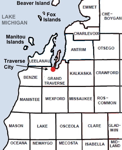
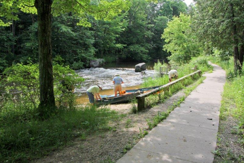
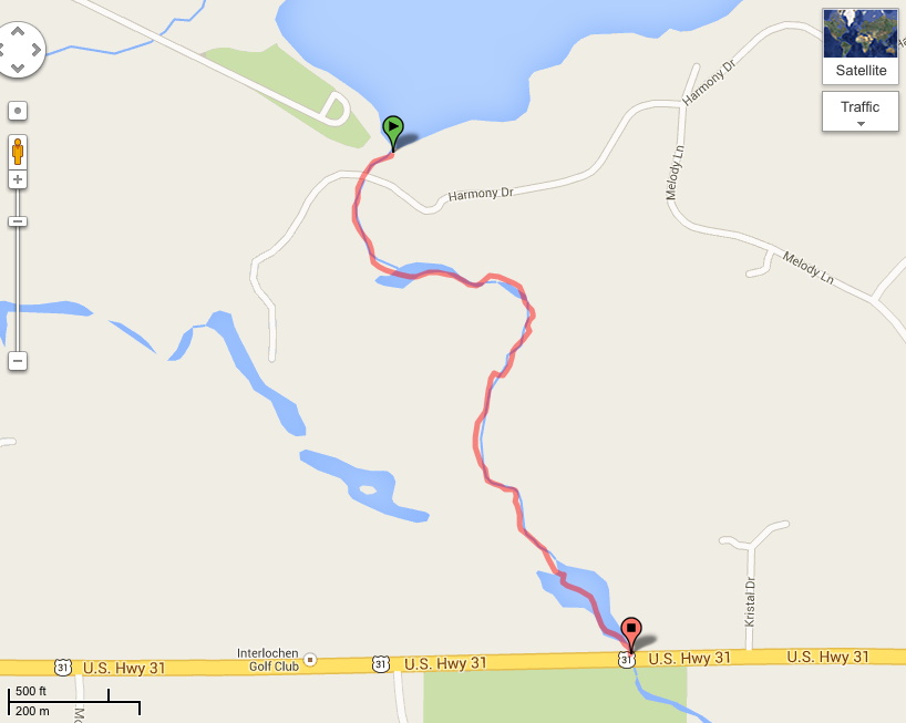
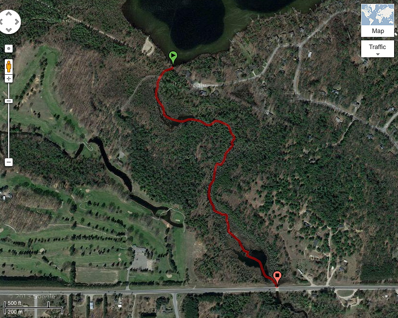
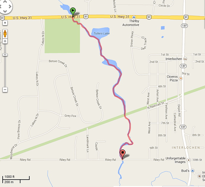
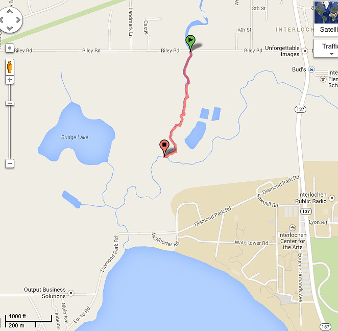
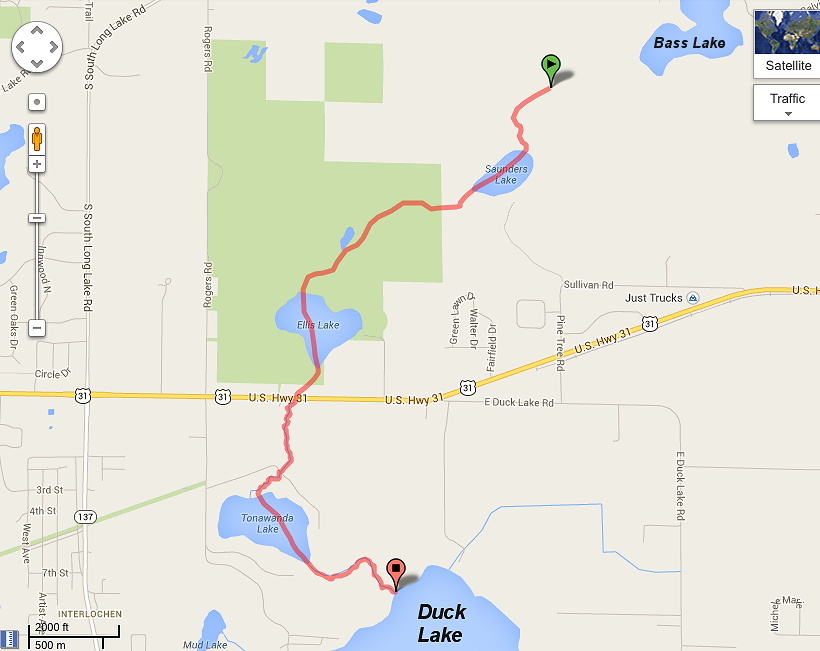
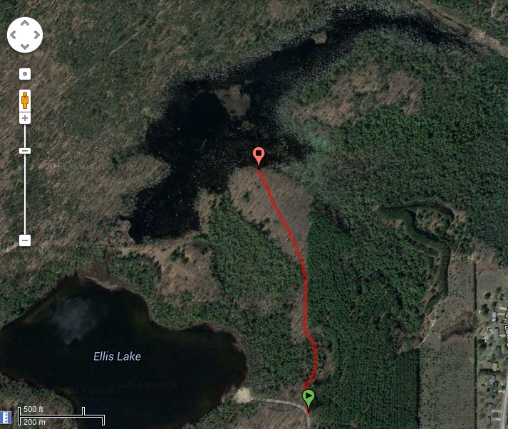
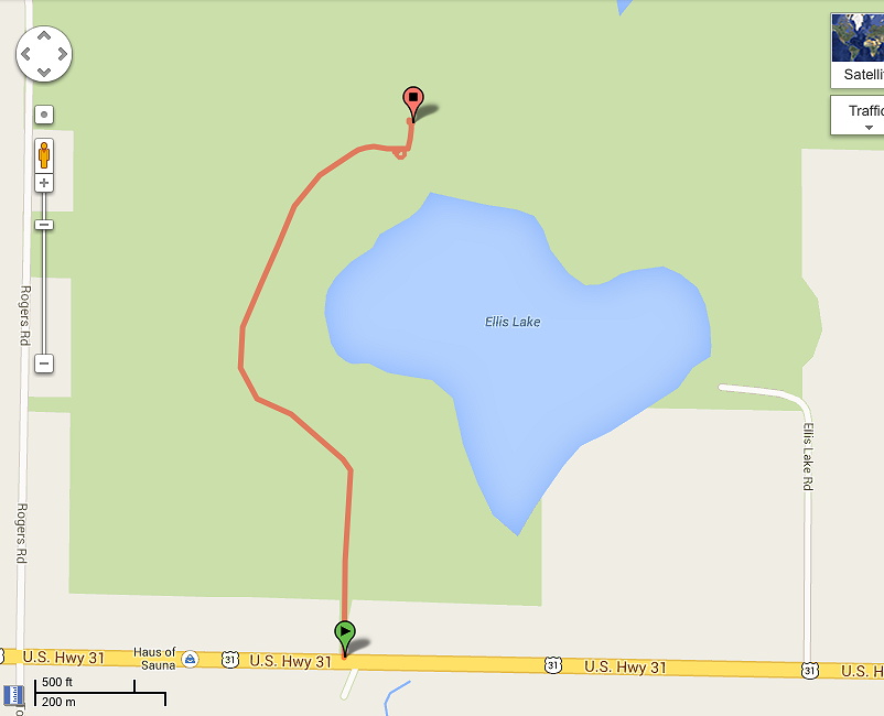
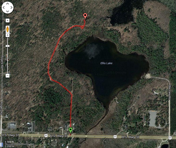
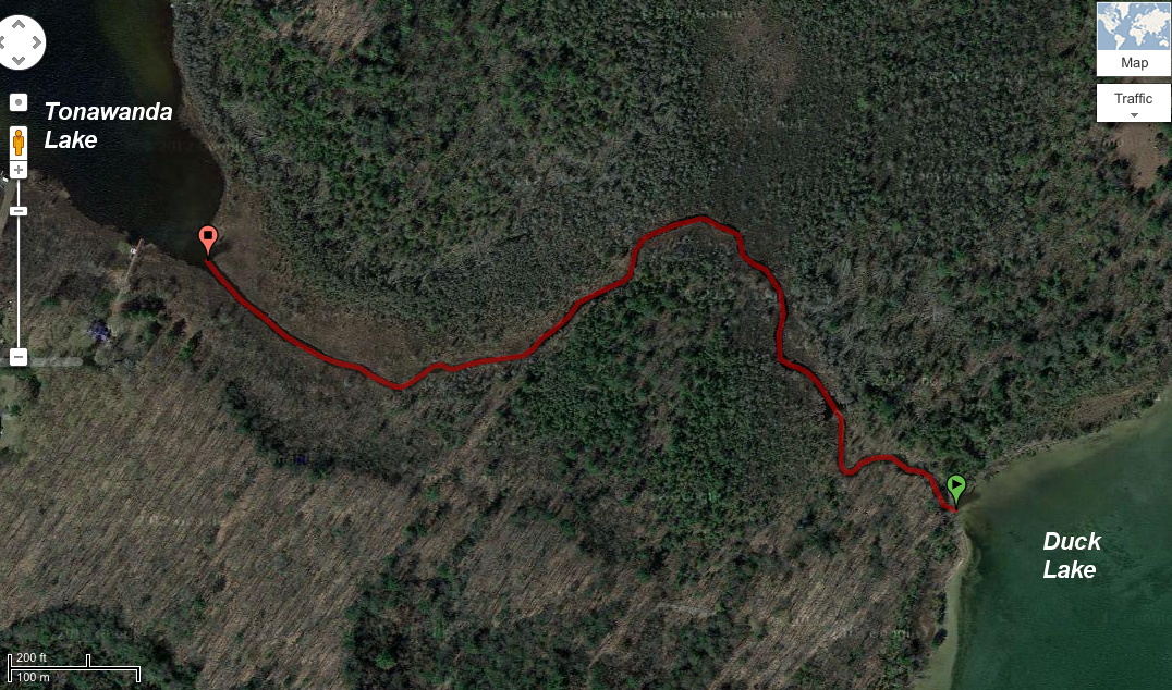
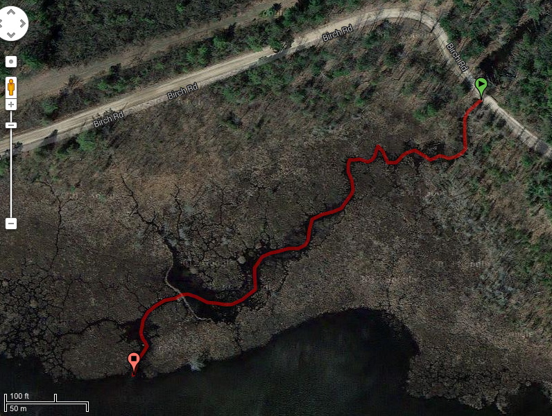
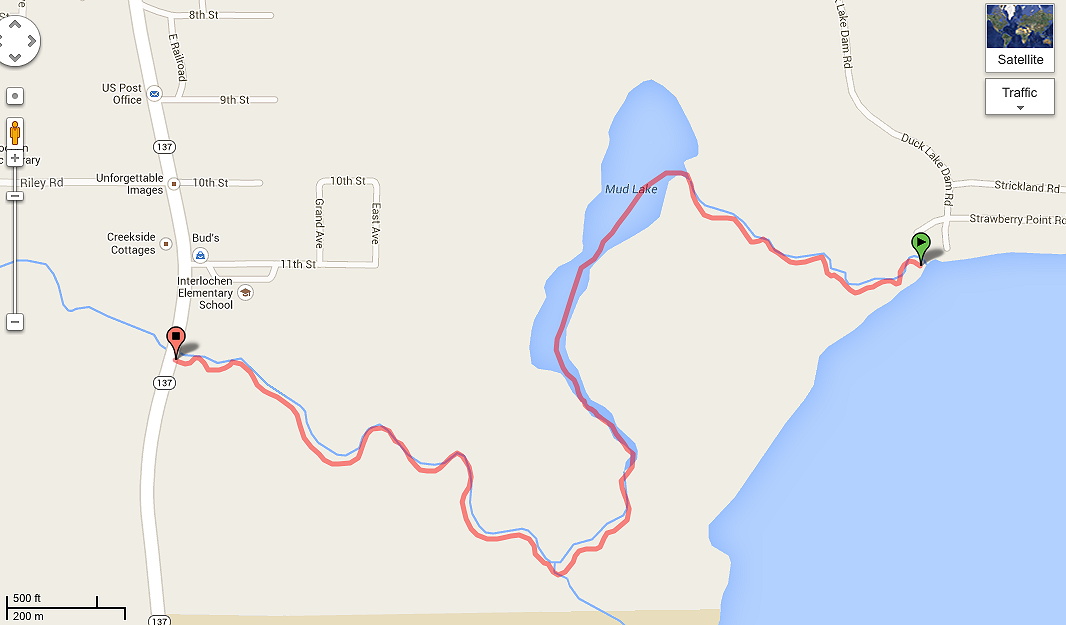
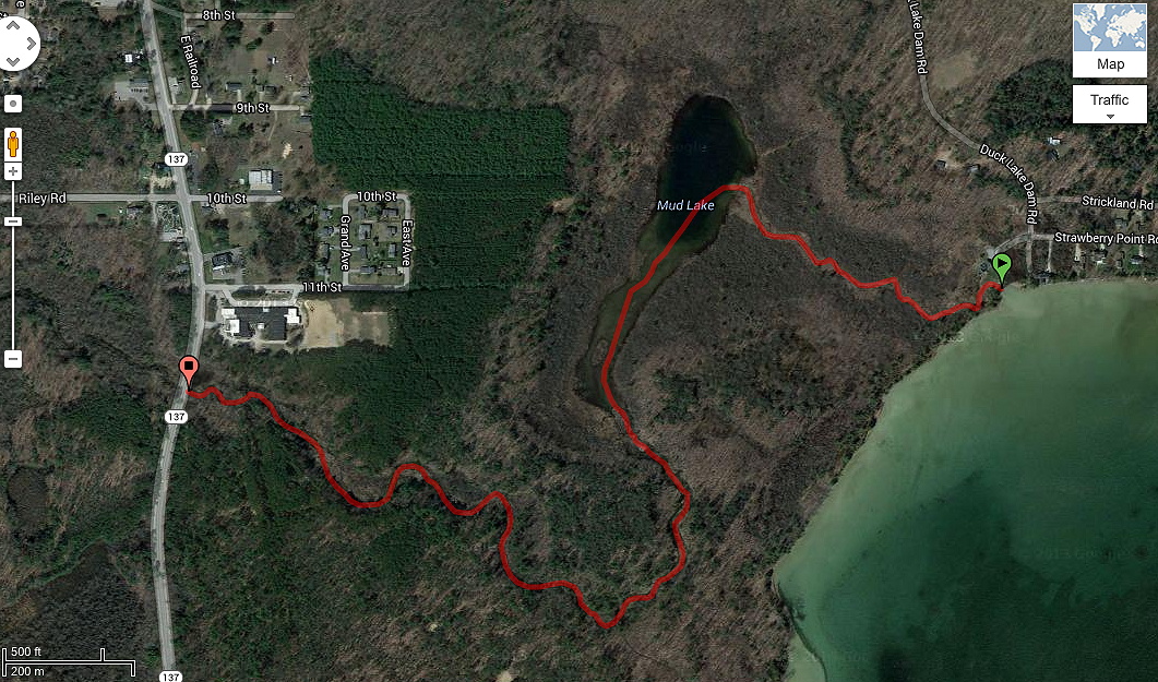
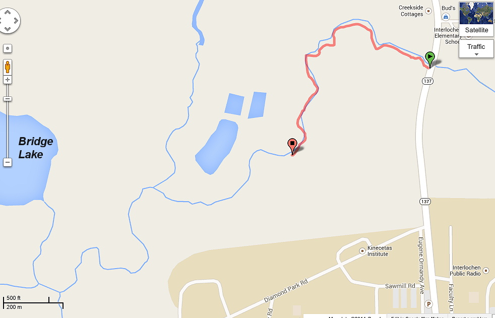
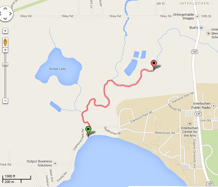
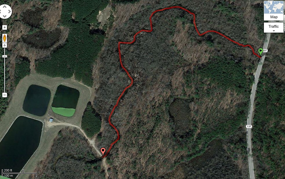
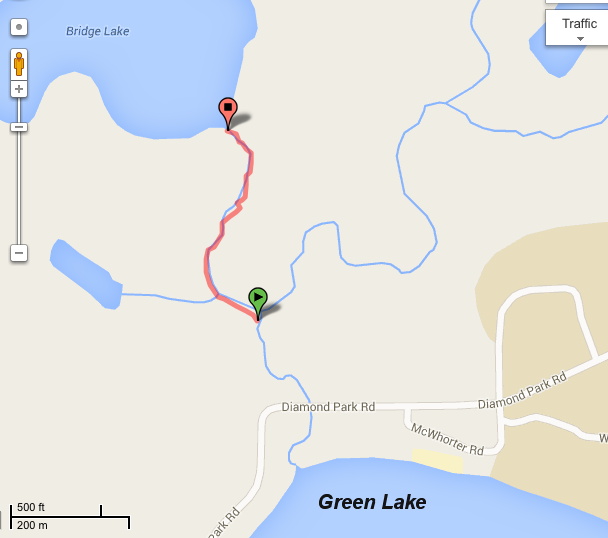
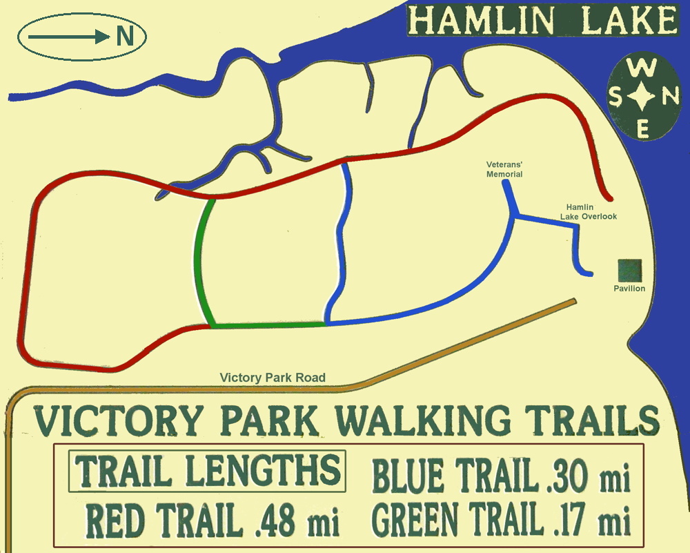
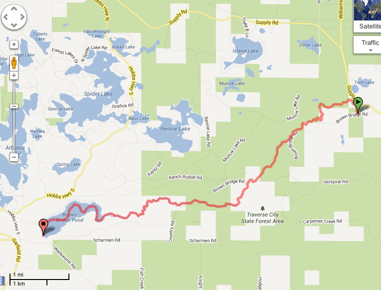
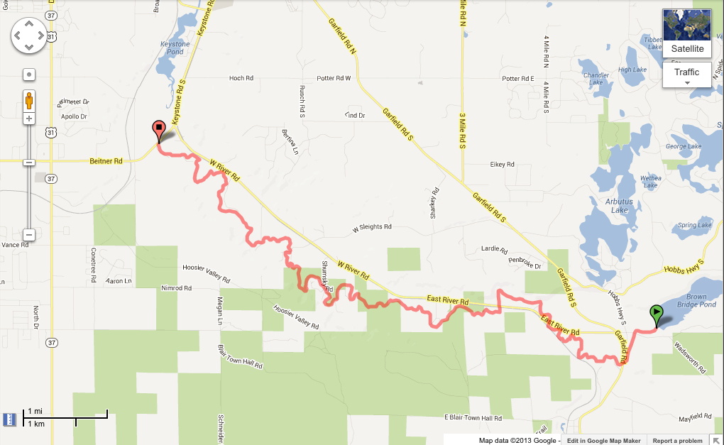
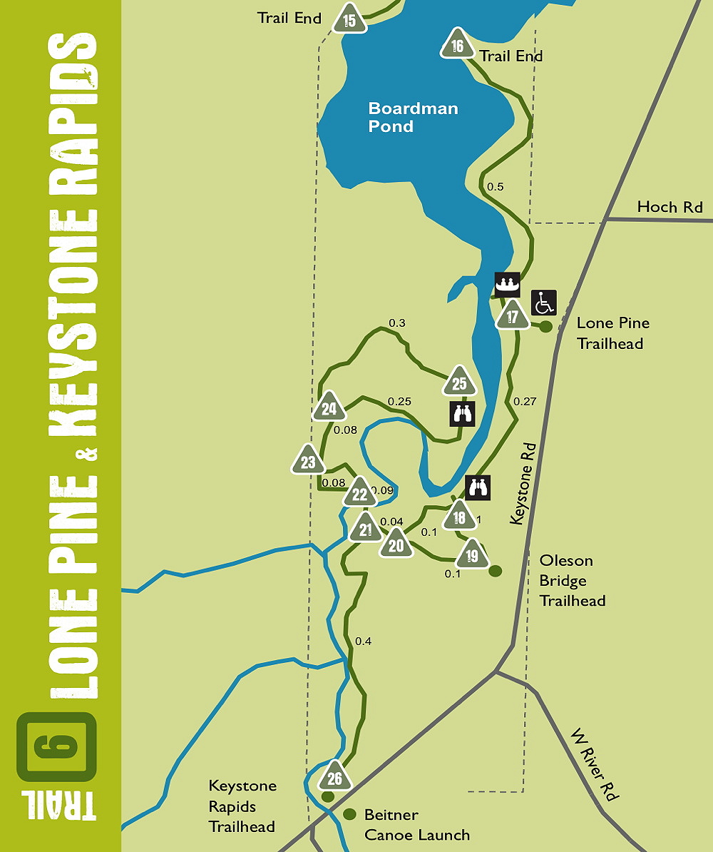
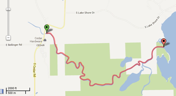
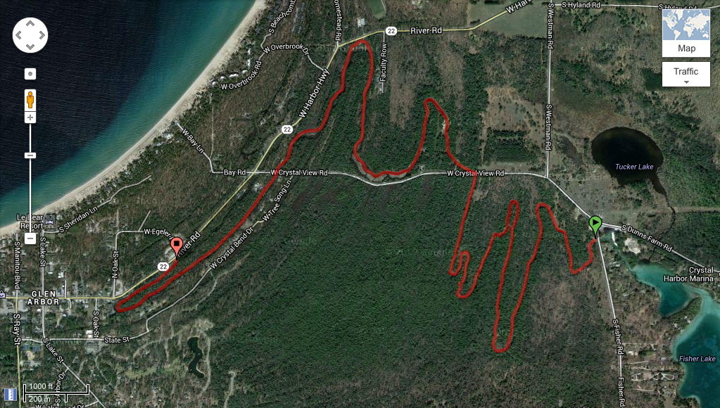
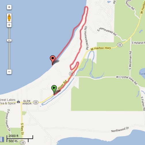
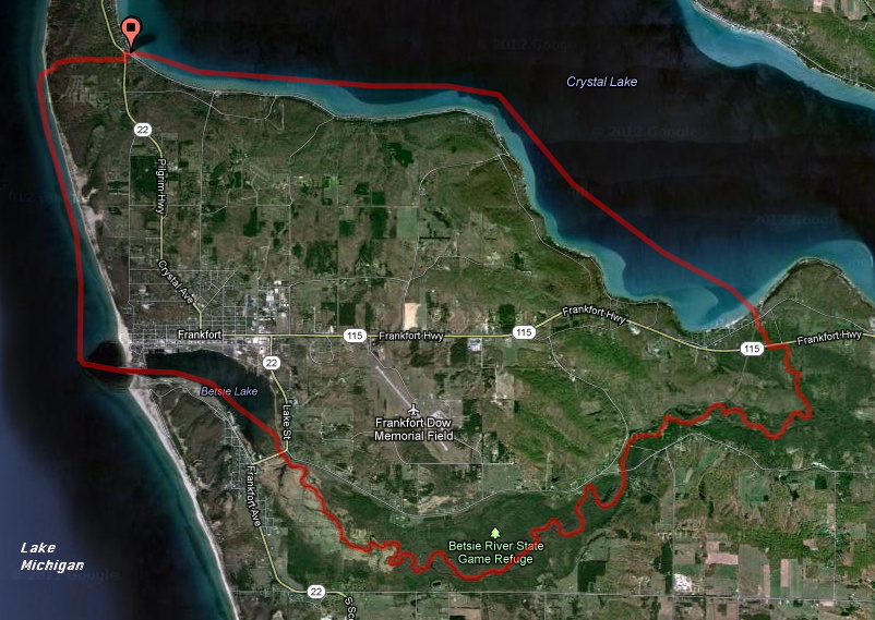
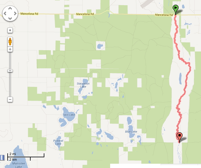
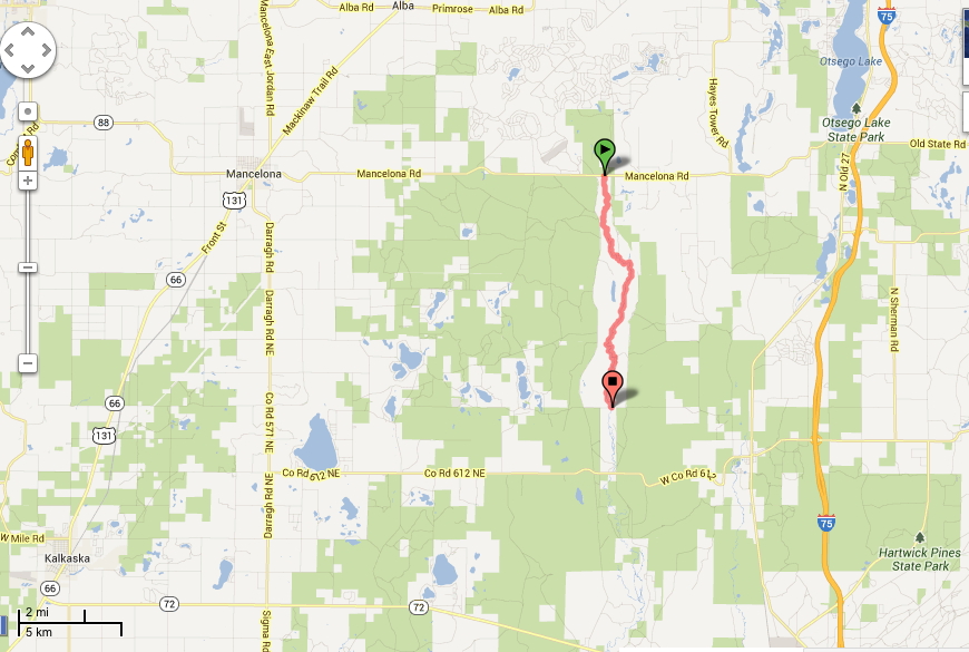
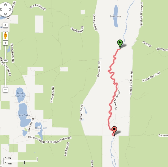
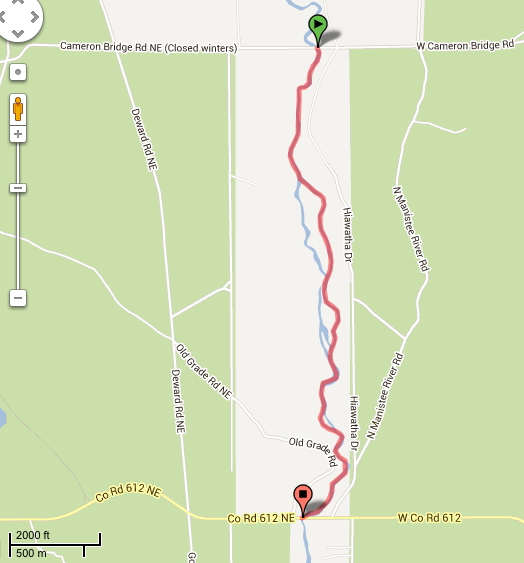
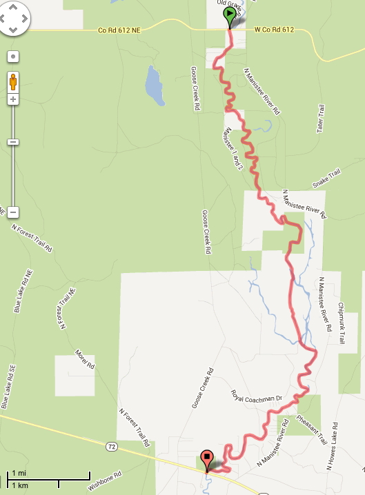
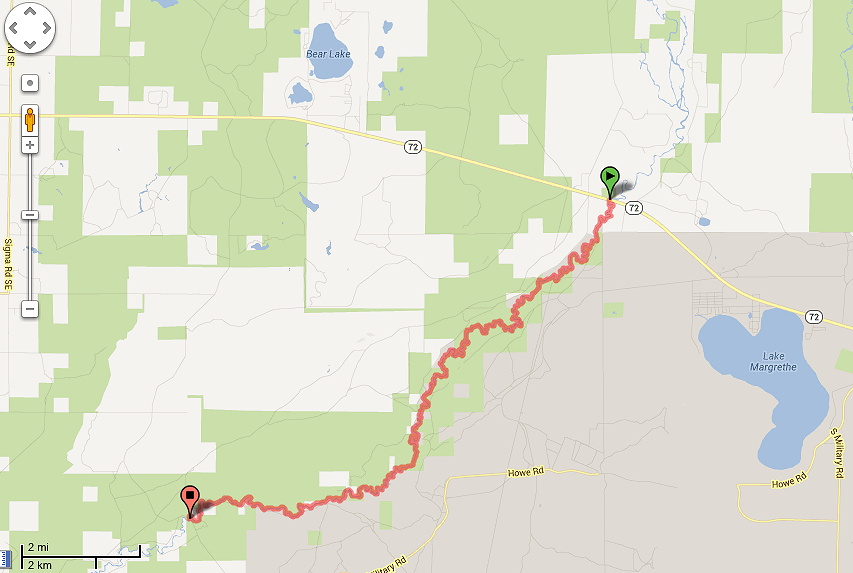
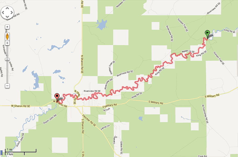
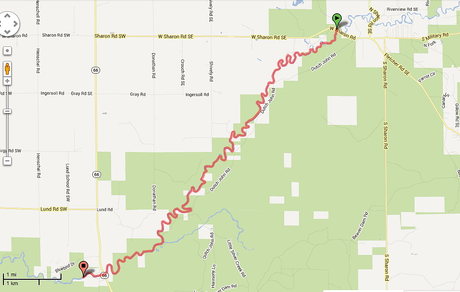
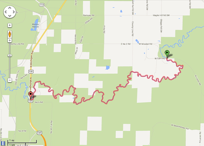
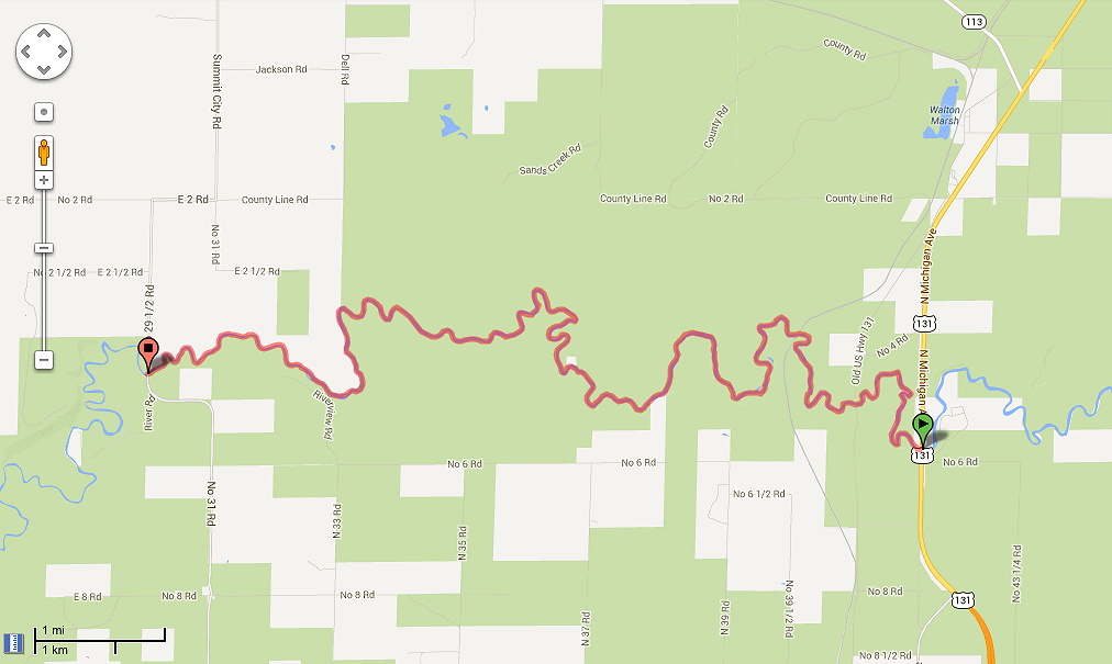
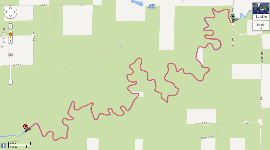
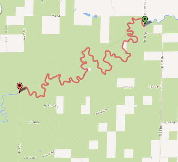
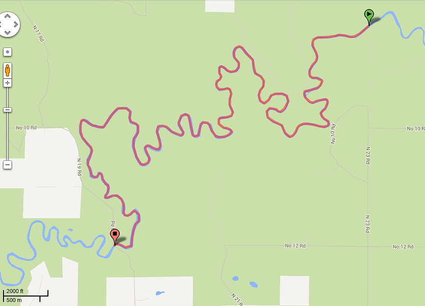
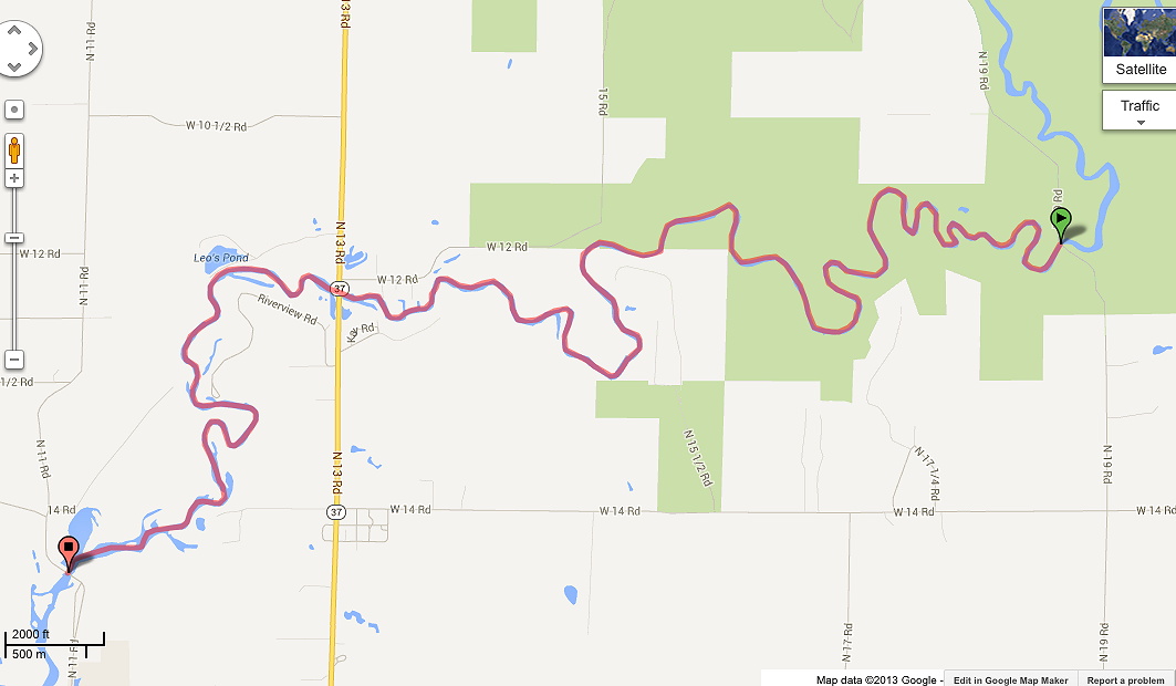
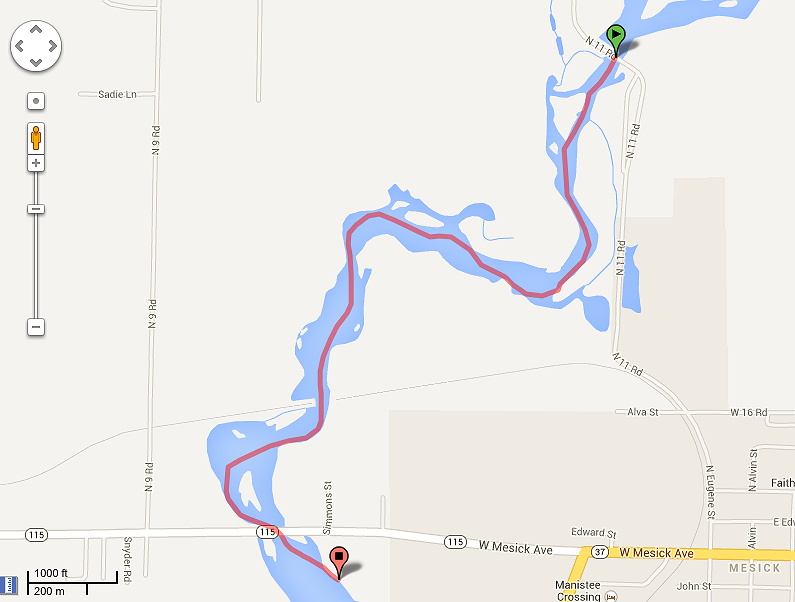
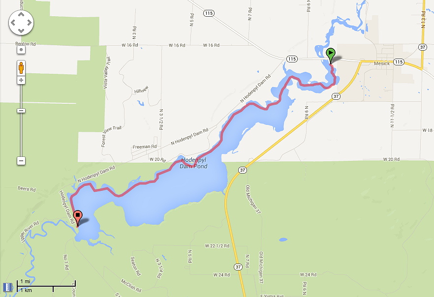
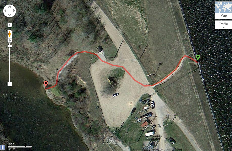
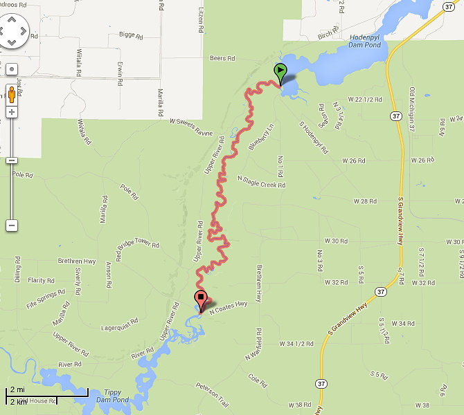
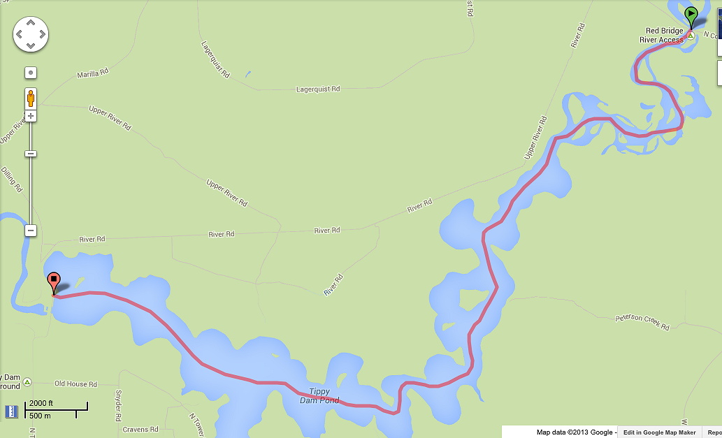
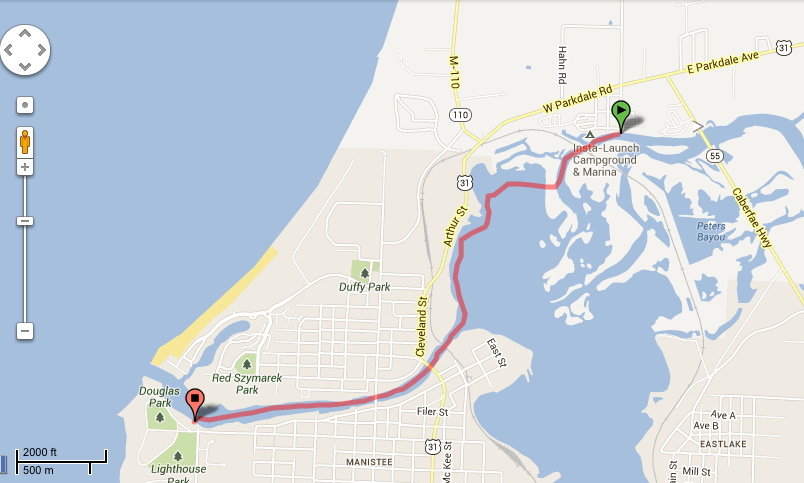
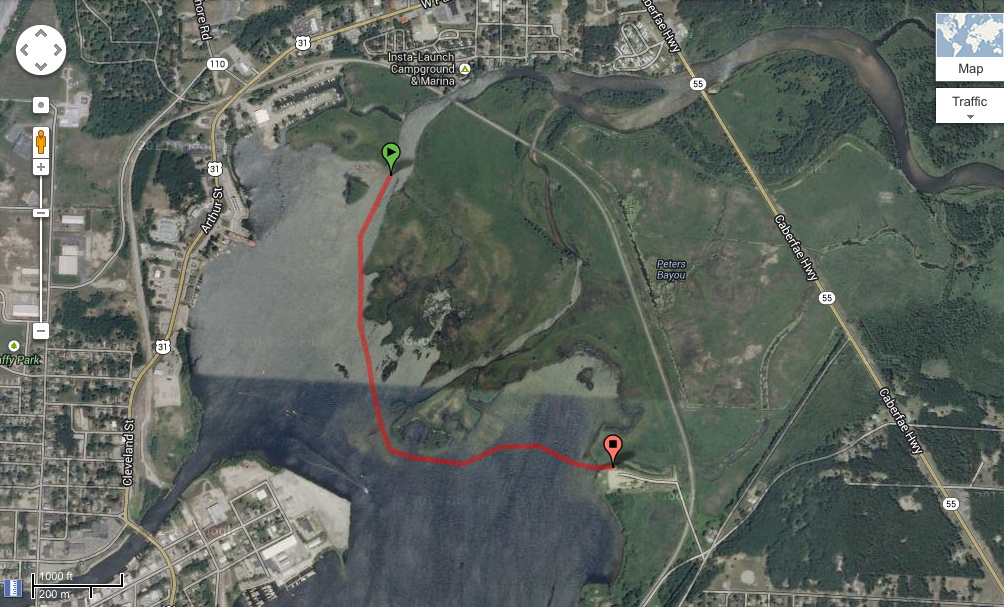
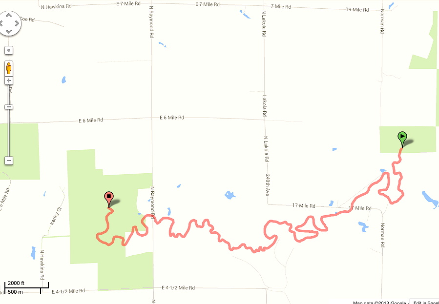
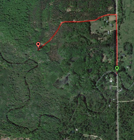
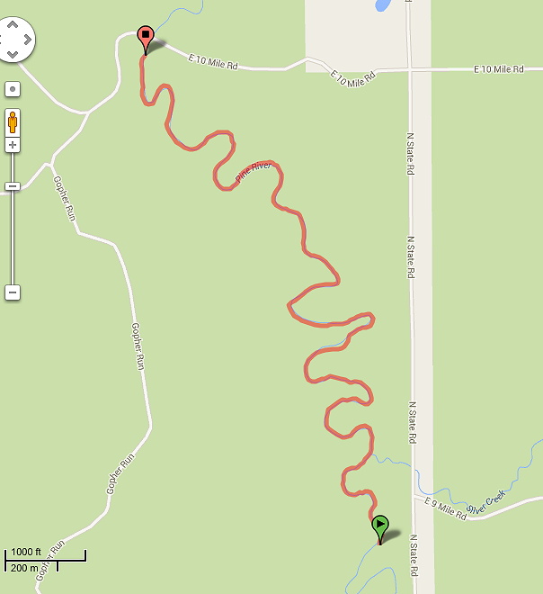
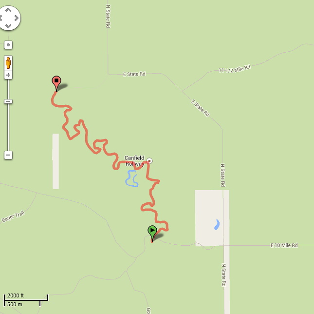
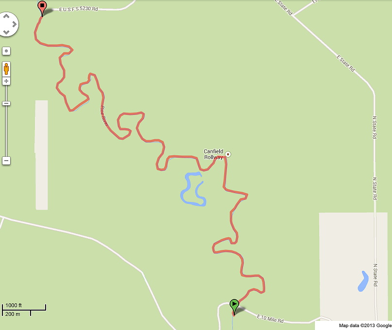
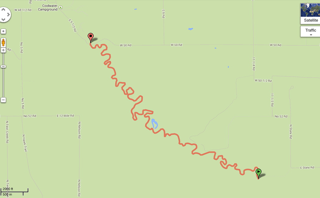
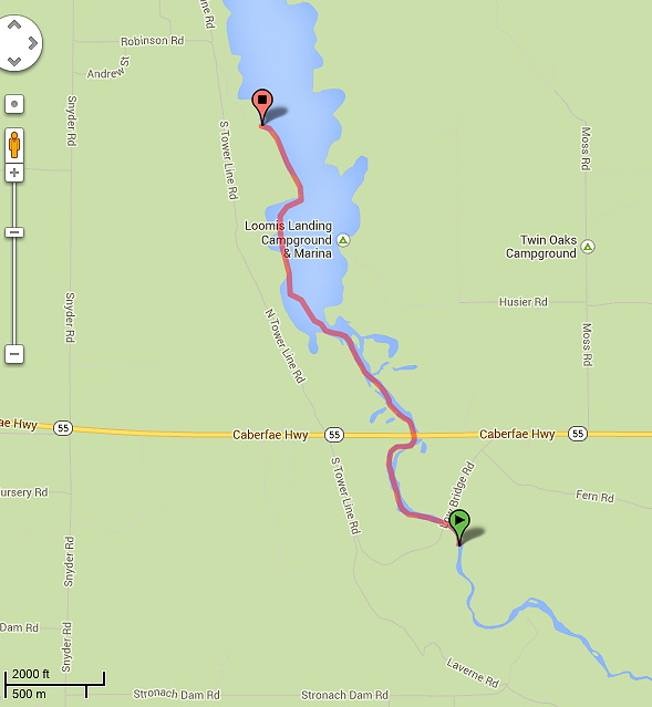