ATI
CONSULTING
![]()
![]()
|
Railroad
Routes of Northwestern |
|
||||||||
| HOME | |
|
SERVICES OFFERED |
|
| | Consulting and Support |
| | Web Site Design
and Domain Services |
|
COMPUTER & INTERNET RESOURCES |
|
| | Computer Resources |
| | Internet Resources |
| | Recommendations
For Healthy Computers |
| | Submit
Your Site to Search Engines |
BENZIE COUNTY, MICHIGAN RESOURCES |
|
| | Benzie
County Michigan Web Site Directory (separate site) |
| | Internet Service
Providers (ISPs) in the Benzie County Michigan Area |
OUTDOOR RESOURCES |
|
| | Canoe & Kayak Links |
| | Ebike Essentials |
| | NW Michigan River Guide |
| | NW Michigan Trail Guide |
| | Railroad Routes of NW MI |
BOOKS |
|
| | Benzie County Trails |
| | Benzie
County Rivers, Lakes, and Creeks |
| | Grand
Traverse and Leelanau Counties Rivers and Lakes |
| | The Savvy Paddler Recreational Kayaking |
|
|
|

|
|
|
WEB SITE ©
Copyright |

| Introduction |
The main focus of this Web page is the exact routes of the areas many physical railroads.
The details of what a railroad did exactly at its starting and end points, how it interchanged with other railroads there and at the crossings and junctions with other railroads. as well as what it did in cities, such as Cadillac, Charlevoix, Kalkaska, Manistee, Petoskey, Traverse City, are not covered well at all. (The focus is on the route outside of any town or city.)
The actual railroad companies involved with any route is less important, for one because they were often purchased by, owned by, or merged with other companies. They are hard to keep track of unless one looks at a specific piece of track at a specific time. Adding to the confusion, some railroad companies leased the rights to use a given section of track from the railroad company that owned the track. So more than one railroad company may run a given section of track.
The history of each railroad company is also less in importance, as is the history of a given section of track. I have provided what was easily found but its likely not the whole story.
When a railroad was built, stopped being used, or the tracks removed is provided if known.
If the list of stations or stops that were made, and/or the settlements or towns that the railroad passed through on a route could be easily found, thats also provided.
I cover mostly named, established railroads that were present for a relatively long period of time.
But there were also many smaller, short-lived logging railroads throughout the area, with sections and spurs that moved around a lot to log off the timber throughout an area of interest or ownership. I cover a few of these, but not most. And I dont cover the railroads on the South and North Manitou Islands.
Also not covered are any of the depots or other buildings or structures along a railroad.
| I. Areas Covered |
All of Antrim, Benzie, Charlevoix, Grand Traverse, Kalkaska, Leelanau, Manistee, and Wexford Counties, as well as some of Crawford, Emmet, Lake, Mason, Missaukee, and Osceola Counties, and the very southeastern corner of Otsego County.
| II. Definitions |
- Branch a railroad that diverges from the main line that usually was
long but also (eventaully) a dead end. Some had wyes or turntables at the end.
- Crossing two railroads crossing each other, sometimes called a diamond
crossing in reference to the diamond-shaped center. In a simple crossing, there are
no switches involved and so the two sets of tracks need not be of the same gauge.
With a more complex crossing there maybe several switches involved using short
connecting tracks between the railroads. All of this assumes a level crossing (or
grade crossing), which is an intersection where a railroad crosses another railroad,
a road, or a path at the same level, as opposed to the railroad crossing over or
under using a bridge or tunnel.
- Junction a point where three or more railroads of the same gauge meet.
(Said another way, a place at which two or more rail routes converge or diverge.)
It may involve just a single switch or there may be many switches involved.
- Railroad (RR) (my own) a physical road made of rails, its sometimes
also called a railway or railway line.
- Railroad company a company that operated trains on specific sections
of railroads. (Sometimes very confusingly called a railroad or railway,)
- Siding a railroad that switched off of the main track and ran parallel
to it with a switch at each end and usually ran for just a short distance.
- Scissored (my own) to cross at a slight angle, between 0 and
45 degrees.
- Spur the same as a branch but usually very short and was a dead end
- Switch at a junction of one railroad with another, this is a mechanical
device used to route a train onto the tracks of the other railroad, which could be
a spur, siding, branch, or separate railroad company. A switch is thrown manually
by a trainman, or electrically at a rail command center.
- Turntable a large spin-able table for turning railway cars and more
typically locomotives so that they can be taken back in the direction from which
they came.
- Wye a meeting of three railroads at a triangular junction with a switch at each point of the triangle. This allowed a train to go in either of the two directions regardless of the direction it is coming from and allowed a train to turn around. A turning wye with two shorts spurs was sometimes put at the end of line to allow a train to turn around.
| III. Interesting Facts |
- A few previous names:
- Lake Cadillac was originally called Little Clam Lake.
- Lake Charlevoix was originally called Pine Lake.
- Lake Missaukee was originally called Muskrat Lake.
- Lake Mitchell in Michigan was originally called Big Clam Lake. The name was changed in 1903.
- The Pine River was originally called the South Branch of the Manistee River.
- In 1918 Leelanau County had as many tracks as it would ever have.
- As of 2018 (and likely a few decades before) there are no tracks in Benzie or
Leelanau Counties.
- Some of the railroads, especially those used for logging, had several spurs along
the way or at the end of their line. These came and went as needed.
- There were many smaller, short-lived logging railroads throughout the area, some
lightly built, and some were narrow gauge. Some had branches, spurs, and ends that
moved around as the wood ran out. A few examples include:
- Beulah (CLC)
- Edgewater (Railroad N),
- Glen Arbor (GALC)
- Glen Haven (Railroad O),
- Jennings (J&NE),
- Watervale (Railroad V),
- State Road (east of Honor)
Its been suggested that the right-of-way for what now is State Road east of Honor was originally built by the Crane Lumber Company to access its timber holdings in that area. On one map this is labelled Old R.R. Grade. The State Road name appears to come from the State Lumber Company of Manistee who acquired much of the timberland in that area previously owned by the Crane Lumber Company by 1901.

The right-of-way started from near the intersection of Goose and Pioneer Roads and very close to the Platte River. It then went 7 miles NE to the intersection of Almira Road with C.R. 669. Around a half of a mile of what is now Pioneer Road going northeast of Goose Road was part of this railroad. So was the four miles from U.S. 31 NE to Hooker Road, which are now an existing gravel road and two-track. Also, the northern two miles of that railroad grade are now part of C.R. 669.
Its not clear how the logs harvested along that route made it to the mill. One suggestion is that the M&NE rebuilt this narrow gauge railroad into a standard gauge, then used its Platte River Branch to take logs back to the mainline, and from there to the mill in Manistee.
- Beulah (CLC)
| IV. Railroad Companies Involved |
Towns with Railroads |
Note: The full name for most of these is the name below plus Railroad Company
A&BR C&LC CLC F&PM GLC LST ME&W PRR AA C&NE CS F&C GR&I LTC MNR SOO BC&SE C&NM CSX F&SE GRK&SE M&GR MR TWC BCG&A C&NW D&C G&W J&NE M&L NYC TCL&M BF&NE C&O DGR&W GALC LN M&NE OL&W TCR BL&E C&WM E&SE GBW LSR M&NW PC TSBY BVLT&M Chessie EJ&S GH LSSL MC PM W&BV C&D
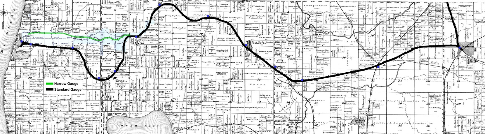
- A&BR Arcadia and Betsie (Betsey) River [ back to RAILROAD COMPANIES ]
- Railroad M
- Connects with the Railroad A just northwest of Copemish.
- Owned by the Henry Starke Land and Lumber Company.
- 1881 or 1883 It started out as a narrow gauge railroad called the Arcadia & Betsey River Train Railway (A&BRT) and went straight east more or less from just north of Arcadia to Malcolm (around 5 miles). The rails were wood with strips of steel.
- 1893 or 1895 It was replaced with standard gauge, its starting point was moved to be just south of Arcadia, and its route now dipped down to the south a bit before reaching Malcom to access new timber areas.
- 1895 It was renamed the Arcadia & Betsey River Railway and reached Henry (around 17.5 miles) that already Railroad H went through. (They built a station there and called it Henry, in honor of Henry Starke, the principal owner.)
- 1896 The railroad extended to Copemish.
- 1918 The section from Henry to Copemish was abandoned.
- 1936 All service on the line was discontinued.
- 1937 The railroad was abadoned and the rails were removed.
- AA Ann Arbor [ back to RAILROAD COMPANIES ]
- Originally the Toledo, Ann Arbor, and North Michigan
- In 1895 it was named just Ann Arbor Railroad
- Railroad A and Railroad P
- Began service from Toledo to Frankfort on 11/25/1889.
- In 1925, the Wabash System obtained control of the Ann Arbor Railroad" says Michigan's Railroad History.
- In 1963, "Detroit, Toledo & Ironton Railroad assumed management of Ann Arbor Railroad" says Michigan's Railroad History.
- In 1976, "The Michigan Department of State Highways & Transportation (MDSH&T) acquired the Ann Arbor Railroad, including rolling stock and right of way from Toledo, Ohio, to Ann Arbor, and Ashley to Cadillac" says Michigan's Railroad History.
- In 1977, "Michigan Interstate Railway Co. assumed operation of Ann Arbor
Railroad from Conrail" says Michigan's Railroad History.
- BC&SE Boyne City and Southeastern [ back to RAILROAD COMPANIES ]
- An early name for the BCG&A
- An early name for the BCG&A
- BCG&A Boyne City, Gaylord, and Alpena [ back to RAILROAD COMPANIES ]
- It began in April 26, 1893 when it was first incorporated as the Boyne City & Southeastern Railroad. It began operating between Boyne City and Boyne Falls in August of that year.
- In 1894, the name was changed to the Boyne City & South Eastern Railroad, and then in 1897 the line once again became the Boyne City & Southeastern Railroad.
- In 1905, the Boyne City, Gaylord & Alpena Railroad was incorporated.
- August, 1918, the RR was completed from Alpena to Boyne City.
- It had branches and spurs all over off of its mainline.
- Stations or stops involved for the mainline, from west to east: Boyne City, Doyles Cusfman, Moore (where there was a short connection over to Railroad C at Boyne Falls), Project (southwest of Boyne Falls), crossed the Railroad C just north of North Elmira (overhead crossing), Mosher, Marion (different from the one by Cadillac), Hallock, Hamiltion, Anderson, Gaylord, and east to Alpena.
- It connected with MC at Gaylord.
- Declining traffic and revenues resulted in bankruptcy and the BCG&A was scrapped
in 1935
- BF&NE Boyne Falls & Northeastern [ back to RAILROAD COMPANIES ]
- Also known as the Cobbs & Mitchell Logging Railroad, but realize that Cobbs & Mitchell had several logging railroads in northwestern Michigan. So, expect to see several other relatively short railroads with the same name in northwestern Michigan
- Construction began at Boyne Falls around 1898.
- It operated from 1902 to 1924.
- As its name implies, it had branches and spurs all over off of its mainline northeast of Boyne Falls.
- Over its lifetime, the railroad built around 100 miles of track.
- The most it operated at one time was 40 miles of track from 1908 to 1910. But by 1912 that had fallen to 25 miles.
- The line was abandoned by 1926 or 1927.
- BL&E Bear Lake and Eastern [ back to RAILROAD COMPANIES ]
- Railroad R
- In 1875 the Bear Lake Tram Railway began operation as a tram railway to haul lumber and freight six miles between Pierport and Bear Lake. The tram's rails were made of maple with steel strapping, and the car was pulled by horses.
- In 1882, the tramway was replaced by the Bear Lake and Eastern Railway, a narrow gauge railway with steel rails. It was complete from Pierport to Bear Lake
- By 1887 it had 18 miles of mainline.
- The company had a locomotive and forty cars, so the railway could handle far more lumber and fruit products than the old one-horse tram.
- It ran until 1902 or 1903 when it was abandoned.
- BVLT&M Bay View, Little Traverse & Mackinac
- Became the Harbor Springs Branch of Railroad C.
- Incorporated in 1879
- Completed in 1882
- The GR&I acquired it in 1888
- 6 miles long
- Note that Harbor Springs was originally called Little Traverse.
- C&D Cummer & Diggins
- Narrow gauge.
- Built and operated by the Cummer & Diggins Lumber Company.
- Railroad AE.
- By 1917 there were 45 miles of tracks.
- This appears to have also been called the Cadillac & Northwestern Railroad, at least in the 1908 era when the early phase of this railroad crossed Railroad A just southeast of Boon. (I found just one reference to the Cadillac and Northwestern Railroad online and it was about this crossing.)
- C&LC Cadillac and Lake City Railway [ back to RAILROAD COMPANIES ]
- Incorporated Mar. 5, 1963.
- June, 1964 Began operations using steam locomotives
- Service was discontinued Feb. 2, 1976
- The line was abandoned Aug. 16, 1984
- Traveled on the Missaukee Branch from
Lake City to Sandstown, then to the Missaukee Junction and Falmouth
- C&NE Cadillac and Northeastern [ back to RAILROAD COMPANIES ]
- Owner and operated by the Cummer Lumber Company in Cadillac
- Narrow gauge 36" wide
- It was 15 miles in length
- In 1878, funds were sought for a projected railroad between Cadillac and Muskrat Lake (Lake Missaukee), so as to remove timber from a large tract of pine.
- The railroad opened in October of 1884, operating as a logging railroad until December, 1885. After that it carried general freight and passengers between Cadillac and Lake City.
- In 1896 it 15 miles long.
- In 1897 it pared back to just four miles in length.
- By 1900 it was out of service.
- It operated in Wexford and Missaukee Counties.
- Stations going northeast: Cadillac, crossing Railroad C, Blodgett, Gerrish, (E.) Komoko (or Komas) Park, McMillen, and Lake City.
- "This railway began in the Harristown section of Cadillac, ran on a straight course toward Haring Road south of the section line where the GR&l later built a roundhouse. It angled across later what was to be the county fairgrounds, then followed the north bank of Clam River to the Wexford-Missaukee County line. Near this location, a mill and settlement called Crooked Lake was built. From this point a road was extended to the northwestern shore of Muskrat Lake, which later would be named Lake Missaukee." Michigan's logging railroad era, 1850-1963, Clark Digital Collections.
- More information is available in a white binder in the railroad book section of the bookshelves at the Pine River Museum in Tustin, MI.
- C&NM Chicago and North Michigan [ back to RAILROAD COMPANIES ]
- A subsidiary of the C&WM
- A subsidiary of the C&WM
- C&NW Chicago and Northwestern (or CNW) [ back to RAILROAD COMPANIES ]
- Also known as the Northwestern
- Also known as the Northwestern
- C&O Chesapeake and Ohio [ back to RAILROAD COMPANIES ]
- Took over the PM in 1947
- Took over the PM in 1947
- C&WM Chicago and West Michigan Railway [ back to RAILROAD COMPANIES ]
- Became part of the PM in 1899 or 1900
- Became part of the PM in 1899 or 1900
- Chessie System [ back to RAILROAD COMPANIES ]
- Somehow swallowed up the PM.
- Later merged with Seaboard Coast Line Industries to form CSX Transportation.
- CLC Crane Lumber Company (May not have been its official
name) [ back to RAILROAD COMPANIES ]
- A narrow gauge logging railroad.
- Four miles long.
- From Beulah it followed what is now Narrow Gauge Road to Marshall Road, and from there dipped south a little before crossing Narrow Gauge Road again (where there was alo a spur to the NNW), then headed northeast across Zimmerman Road and ended near Rockwell Road.
- Narrow Gauge Road got its name from this railroad.
- Not a lot could be found about this railroad, but there is strong evidence to suggest that it was built by the Crane Lumber Company, which had a mill in South Frankfort (now Elberta), which laid several narrow gauge lines throughout Benzie County. In this case, it is believed that this narrow gauge railroad was built to access the lumber company's timber holdings south of Honor at the east end area of the present-day Narrow Gauge Road.
- Believed to be built starting in 1886, this was before the F&SE was built through Beulah. Its been suggested that logs were moved somehow from Beulah WSW over to a rollway on the Betsie River. But the hills involved next to Crystal Lake are too steep for a railroad to be plausible. But if this was done, logs might have been hauled some other way. Its also possible that logs were floated across Crystal Lake over to the Crystal Lake Outlet which empties in the Betsie River and then floated to the mill at South Frankfort.
- Once the F&SE at Crystal City and Beulah Resort (now known as just "Beulah") was in place by 1888, this narrow gauge railroad came next to and paralleled that new standard gauge railroad (later purchased by the AA) at the depot. From there the logs were transferred over and reloaded, then transported by that new railroad to the mill in South Frankfort.
- This concept, at least, was confirmed by Bruce Catton who wrote about this four-mile-long narrow-gauge railroad in his famous Waiting for the Morning Train book. It was built before the turn of the 20th century and was very short-lived, and all but forgotten by the early 1900s. But it did as mentioned above, it brought logs from the east to Beulah, where they were transferred to the then F&SE and taken to the Frankfort area.
- I found one source that said this railroad was called the Benzonia, Beulah
and Lake Michigan Railroad, but thats rather questionable and no mention of
that could be found online. But the rest of what they said seemed close to being
correct. The railroad operated in the late 1800s and early 1900s, and was originally
built to transport lumber and other products from the forests around Beulah to the
nearby sawmills and shipping docks. The railroad was first constructed in 1888. The
line was built using narrow-gauge track, which allowed for tighter turns and steeper
grades than standard-gauge track, making it easier to navigate the hilly terrain
around Beulah. In the early 1900s, the railroad was sold to a new owner who attempted
to convert it to a standard-gauge line, but the effort was unsuccessful and the railroad
was eventually abandoned in the 1920s.
- CS Cold Springs [ back to RAILROAD COMPANIES ]
- The Antrim Iron Company was founded in 1886 and for many years was the main employer in Mancelona. During the companys heyday, it possessed its own railroad, which appears to be this railroad (and not the M&NW).
- It was a standard gauge line, which went, via two branches, both NE and SE of village of Antrim, starting in 1907.
- The northeastern fork crossed Railroad AA ESE of Alba.
- The Antrim Iron Works furnaces were closed down in 1943, the associated sawmill
ceased production in 1945, and the iron works was demolished in the mid-1980s
- CSX CSX Transportation [ back to RAILROAD COMPANIES ]
- D&C Detroit and Charlevoix [ back to RAILROAD COMPANIES ]
- Railroad AA
- It went from the town of South Arm (in 1905 it merged with East Jordan) on the shore of Lake Charlevoix to Frederic, where there was a junction with MCs Mackinac Division.
- It began as the F&C and was used to haul harvested timber to sawmills.
- In 1901 it became the D&C and was incorporated as a common carrier. A sawmill and supporting structure were build in Deward near the Manistee River. In 1912, after clearcutting all of the forested holdings of the company, the sawmill was dismanteld and sold, and Deward began its journey to becoming a ghost town.
- The MC took over the D&C in 1907, but operated it separately.
- In 1912 or 1916 it merged with the MC, and became known as their East Jordan Branch.
- In 1930 it stopped operating and in 1933 the line was abandoned.
- "At one time, the D&C was reputed to be the longest railroad in Michigan owned by one person (David Ward)" said Michigan's Railroad History.
- There were plans to extend the railroad to Charlevoix but it never actually went
there. Nor did it ever reach Detroit!
- DGR&W Detroit, Grand Rapids, and Western [ back to RAILROAD COMPANIES ]
- Became part of the PM in 1900
- Became part of the PM in 1900
- E&SE Empire and Southeastern [ back to RAILROAD COMPANIES ]
- Railroad U
- Originally called the T. Wilce Co. Railroad
- It was known by the locals as the "Empire - Slow and Easy".
- They began building it in 1892.
- It was ready for use in 1898 or 1900.
- Abandoned in 1921 or 1923
- The line ran 12 miles from Lake Michigan at Empire to the Empire Junction where it connected to the Platte River Branch of the M&NE.
- The connection with the M&NE at Empire Junction provided
the people of Empire and the surrounding area a reliable year-around access to the
outside world.
- EJ&S East Jordan and Southern [ back to RAILROAD COMPANIES ]
- Railroad Y
- Established in 1901
- Initially built by the East Jordan Lumber Company.
- It went 19 miles from East Jordan to Bellaire at a junction with the PM
- The depot is on the east side of East Jordan on Depot Street just south of State Street.
- Primarily a logging railroad.
- Theis railroad was used to "obtain hardwoods for its East Jordan mill, and also provided waste wood to the East Jordan Iron Company for use as fuel for its East Jordan smelter."
- With World War II, all the forests were depleted and the era of freight movement by railroad ended. However, this railroad line continued as a tourist attraction and the owners established the Swan City Express using Locomotive #6.
- Locomotive #6 for this RR company, a 45-ton, coal-fired Pittsburgh built in 1909, is on display at the Sportmens Park on the west side of East Jordan on the west side of the river off of Mill Street.
- Because of the many struggles encountered on this EJ&S railroad it was nicknamed: "Every Journey a Struggle".
- It was dissolved in May, 1962.
- F&C Frederic and Charlevoix [ back to RAILROAD COMPANIES ]
- Construction began 1886, extending from Frederic northwest.
- In 1887 it was referred to by some as the Alba, East Jordan & Frederic Railroad (AEJ&F), but it was never incorporated as such.
- In 1891 the railroad was now called the F&C and so far, only went to Alba.
- By 1893 it was in operation all the way from Frederic to East Jordan.
- Standard gauge.
- In 1901 become the D&C
- F&PM Flint & Pere Marquette [ back to RAILROAD COMPANIES ]
- The mainline was completed to its western end point of Ludington in December, 1874
- Became part of the PM in 1900
- F&SE Frankfort and Southeastern [ back to RAILROAD COMPANIES ]
- Operated on a part of Railroad A
- Near Frankfort it used the right-of-way established by the earlier narrow gauge Frankfort Furnace Company Railroad, but replaced the narrow gauge with standard gauge.
- Although it began in 1888 or 1889, it was not through to South Frankfort until, in January 1891, when the first train of logs for the Crane Lumber Company arrived in South Frankfort after the bridge over the Betsie River was reworked to accommodate the new standard gauge.
- It was purchased by the AA in 1892
- It was 24 miles long and ran from Frankfort, through Crystal City (now Beulah),
to Copemish
- G&W Genesee & Wyoming [ back to RAILROAD COMPANIES ]
- Railroad K and Railroad L
- 2018: currently in operation
- Purchased MR
- From Wikipedia "An American short-line railroad holding company, that
owns or maintains an interest in 120 railroads throughout five countries: the United
States, Canada, Australia, Belgium, Netherlands and the United Kingdom. It operates
more than 15,500 miles (24,900 km) of owned and leased track, with more than
3,300 miles (5,300 km) under track-access arrangements. The company had its
roots in the Class III Genesee and Wyoming Railroad, which began in 1899."
- GALC Glen Arbor Lumber Company [ back to RAILROAD COMPANIES ]
- A short (just over a mile long), narrow gauge railroad that ran from the northwestern point on Big Glen Lake to a mill in Glen Arbor, then out to a dock on Lake Michigan.
- It appears it was in operation from sometime just before 1900 until 1907.
- From the Big Glen Lake, it started out going northwest but then immediately bent to the west, went straight for a bit, slowly curved to the north, then went out to Lake Michigan.
- GBW Green Bay Western [ back to RAILROAD COMPANIES ]
- Served central Wisconsin for almost 100 years before it was absorbed into the
Wisconsin Central in 1993. For much of its history the railroad was also known as
the Green Bay Route.
- Served central Wisconsin for almost 100 years before it was absorbed into the
Wisconsin Central in 1993. For much of its history the railroad was also known as
the Green Bay Route.
- GH Glen Haven [ back to RAILROAD COMPANIES ]
- Railroad O
- This was just a logging railroad to Lake Michigan.
- It began as a horse-drawn tram road operated by the Northern Transportation Company that went from the mill pond on the northwestern corner of Little Glen Lake to the dock on Lake Michigan at Glen Haven. Loaded rail cars were pulled by a team of two horses walking between the rails to pull them to the dock. (Before that, lumber was transferred to the dock by wagon or sled.)
- The tramway (called Days Tramway) was built in 1870. (One map suggests that the original tramway did not go all the way to Glen Haven, but near the west end of Dune Valley Road, it turned east and followed the path of that road to where it now intersects with M-109. Lumber would have been transported by wagon or sled to the dock.)
- In 1907, owner D. H. Day purchased steel rails (from the now defunct GALC) to build a narrow gauge railroad and he purchased a locomotive to haul the flatcars.
- It was abandoned sometime before 1916.
- GLC Great Lakes Central [ back to RAILROAD COMPANIES ]
- Originally the TSBY
- As of 2018 this company operates the:
- former AA track from Ann Arbor to Cadillac (part of Railroad A),
- former GR&I/PRR from Cadillac to Petoskey (Railroad C),
- former GR&I/PRR Walton to Traverse City (Railroad D),
- former C&O from Grawn to Williamsburg (east part of Railroad H: Grawn to Traverse City, and west part of Railroad E: Traverse City to Williamsburg),
- and many more in other areas.
- GR&I Grand Rapids and Indiana [ back to RAILROAD COMPANIES ]
- Was the first railroad company into the northwestern lower Michigan region going to Clam Lake (Cadillac) in 1871 and Traverse City in 1872.
- The line between Paris and Petoskey, Michigan, was completed November 25, 1873. (Another source said 1874.)
- It extended to Bay View in 1876.
- The railroad was opened to Mackinaw City, Michigan, and the Straits of Mackinac on July 3, 1882.
- On July 2, 1896, the Grand Rapids & Indiana Railroad reorganized as the Grand Rapids and Indiana Railway.
- Later became the PRR.
- Their main line was from Kalamazoo to Mackinaw City (Railroad B & Railroad C)
- A branch ran from Walton Junction to Traverse City (Railroad D)
- A branch ran from Petoskey to Harbor Springs.
- The Manistee Branch, which went west from Milton Junction (a.k.a. Orono Junction) two miles north of Reed City. At Deer Lake there was a junction for the Deer Lake Branch which went southwest toward Lake Junction (the end of that line was Pelton (and later was called Raiguel, Ralguel, or Raignels or Raijuel). The branch was seven miles long and began in 1883. The main Manistee Branch continued on and went through Luther to Carey (Carrey). It was abandoned in 1905
- The Missaukee Branch:
- What eventually became the "Missaukee Branch" began in 1882 and only went to Round Lake. At that time it was called the Round Lake Branch of the GR&I.
- Later in1882 it turned north and reached Jennings, which was the original eastern end of the Missaukee Branch.
- In 1890, when the GR&I built a new segment of track from Round Lake Junction to Sandstown (immediately south of Lake City), the track to Jennings became known as the Jennings Branch.
- The last section of this Missaukee Branch, from Michelson NNE to Michelson Mill (in Roscommon County was completed in 1912.
- When complete, its route was from Missaukee Junction (north of Cadillac) east through Round Lake Junction, Wagner, Lake City Junction (at Sandstown), Falmouth Junction (Veneer), Mynnings, Ardis Junction, Ardis, Merritt, and northeast to Michelson, then NNE to Michelson Mill (in Roscommon County).
- The Missaukee Branch "complex" (of lines) included four sub-branch
lines that stemmed from the main branch:
- Jennings Branch left the Missaukee Branch at Round Lake Junction and went north 3.7 miles to Jennings
- Lake City Branch a short branch built in 1894 that left the Missaukee Branch at Lake City Junction (at Sandstown, aka Sands Junction, aka Sands Town Junction) and went north a little over a mile to Lake City.
- Missaukee City Branch From Ardis Junction it went north around 4 miles to Missaukee City.
- Falmouth Branch (a.k.a. Veneer Branch) finished in 1908, left the Missaukee Branch at Falmouth Junction (Veneer) and went south to Falmouth
- In later years, the main part of the Missaukee Branch between Missaukee Junction
and Lake City was operated by the C&LC, from 1964 to 1971.
This remaining section was finally abandoned in 1984. This Web
page shows the route.
- GRK&SE Grand Rapids, Kalkaska, and Southeastern
[
back to RAILROAD
COMPANIES ]
- Railroad AB
- It seems odd that they used Grand Rapids in the name as it never went anywhere near there. A better name would have been the Rapid City, Kalkaska, and Stratford.
- They used some of the land previously acquired by the Rapid River & Eastern Railroad, which was incorporated in 1892 but apparently never laid down any rail.
- Founded on August 30, 1897.
- Operated at the end of the 19th century and into the early 20th century.
- It was leased and operated by the C&WM and later in 1899 by the PM (when the C&WM became part of the PM).
- In 1903 the PM bought the capital stock of the GRK&SE and gained financial control of the line.
- When all of the timber in the area was harvested, the need for the rail line went away.
- In 1908, the last of the logs were hauled away from the end point at Stratford village and that site became deserted
- In 1915 or 1916, the PM cut the line back to Spencer, eliminating 14 miles of the line.
- In 1918, the line was pulled back to Kalkaska another 7 miles.
- Finally, in 1921, the stretch between Kalkaska and Rapid City was abandoned,
removing the last vestige of the railroad.
- J&NE Jennings & Northeastern [ back to RAILROAD COMPANIES ]
- From Jennings in Missaukee County, this railroad went quite a way to the north and northeast with several branches and spurs.
- Construction of the RR began in maybe 1884 or 1885 by the owner of a saw mill in Jennings.
- It was narrow gauge.
- In 1887 was just 3.9 miles long, and by 1890 it had 10.5 miles of track. Eventually, it more than 60 miles of track, and even went in to Kalkaska County. In fact, at its northern tip, it crossed Railroad J in two places just east of McGee.
- The tracks were removed in Kalkaska County in 1915
- The railroad was discontinued in 1920.
- LN Ludington Northern [ back to RAILROAD COMPANIES ]
- Began in 1896 as the Epworth League Railway.
- In 1901 it became the Ludington Northern.
- In Ludington it joined with the Ludington Division of the PM, a subsidiary of the C&O, just southeast of Ludington proper.
- A single-track line from Ludington to Hamlin Lake.
- It ran for two miles between Ludington and Mt. Epworth and another two miles to the southeast side of Hamlin Lake.
- This was primarily a tourist line.
- Later it transported sand for the glass industry in Ohio.
- Its main commodity was sand: The Sargent Sand Company operated numerous sand mines north of Epworth, near Ludington State Park, to which the Ludington Northern provided shipping service. The sand company soon purchased the Ludington Northern outright, and extended the line northwards to access other sand mines within Ludington State Park.
- At Weimer there was a ferry to Piney Ridge on the west side of Hamlin Lake. Also, at Hamlin Lake, a ferry embarked from there to North Bayou at the north end of Hamlin Lake.
- The entire line was abandoned in 1982 after Sargent Sand discontinued mining
operations in the area. The C&O line to which it connected
is still active today, however, operated by CSX.
- LSR Leelanau Scenic Railroad [ back to RAILROAD COMPANIES ]
- Existed from 1989 to 1995
- Operated by a group of local railroad enthusiasts
- They ran on tracks from Greilickville to Suttons Bay, most of that is part of Railroad G.
- In 1994 they "went out of business as a truck hit one of the lines bridges".
- The right-of-way was turned into bike a trail.
- LSSL Louis Sands Salt and Lumber Company [ back to RAILROAD COMPANIES ]
- Over a period of several years, the Louis Sands Salt & Lumber Company operated at least five segments of logging railroad. Those lines were located in Manistee, Mason, Wexford, Missaukee, and Kalkaska Counties.
- The one descried here was in Kalkaska County.
- The Louis Sands Salt and Lumber Company built the first railroad in the Sharon area, where it dumped logs into the Manistee River.
- It was built in 1895.
- It operated until a few years after the turn of the century.
- By 1910, the railroad was no longer operating. In fact, it is known to be gone before 1909 when the Manistee River Branch of the M&NE (Railroad J) used some of its abandoned grade to reach Sigma.
- It ran from north of Sigma (which was at Sigma Road and Kniss Road) straight south, then went southwest following Number 16 Railroad SE Road, crossed North Sharon Road, turned SSW, crossed Willow Creek Lane (Railroad AB) 783 feet east of Thayer Road, was likely what is now the eastern part of Nagle Road in Sharon. It continued southwest a little and ended along the north bank of the Manistee River.
- A portion of the former LSSL grade was used by the M&NE
for Railroad J. It started just south of Kniss Road where
Railroad J turned east and went south to where Railroad
J turned to the west (east of Sigma Road and north or Mecum Road).
- LST Little & Son Tramway [ back to RAILROAD COMPANIES ]
- Railroad N
- This was a narrow gauge logging railroad to Lake Michigan.
- The engine was a very simple "platform outfit", sometimes called a logging engine. It did not go very fast.
- In 1901 this was just a tramway from Platte Lake (at the Little and Son Saw Mill) that went north to Lake Michigan.
- The part of the former railroad north of M-22 is now part of the Platte Plains Trail (Railroad Grade Trail and more).
- LTC Leelanau Transit Company [ back to RAILROAD COMPANIES ]
- Railroad G
- Was originally the TCL&M
- Was incorporated in 1919.
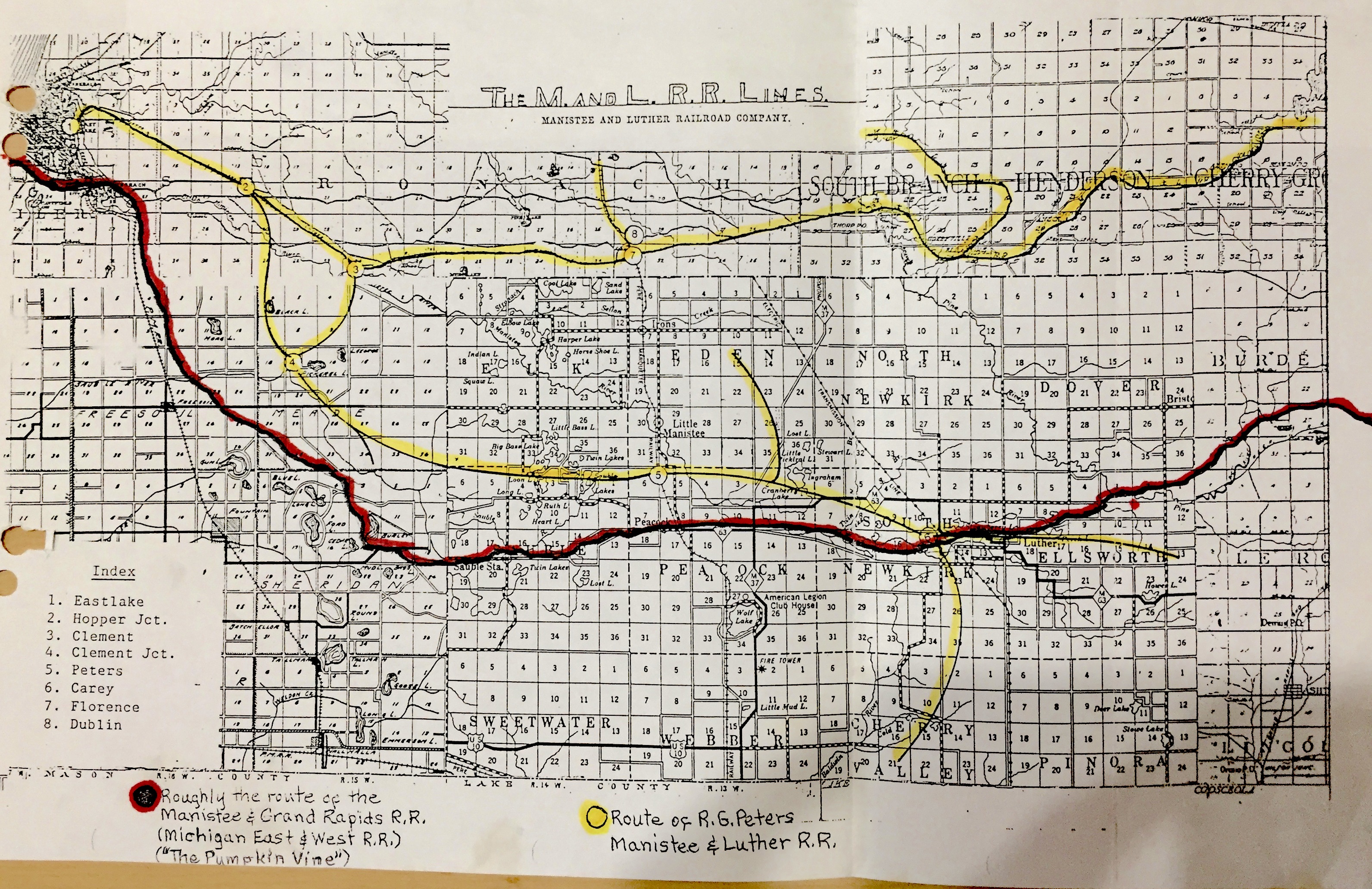
- M&GR Manistee & Grand Rapids [ back to RAILROAD COMPANIES ]
- Railroad AC
- Narrow gauge
- Organized on November 11, 1889.
- The tracks reached Peacock by December 20, 1892.
- Arrived in the Luther area by 1896.
- It reached Marion by 11/1905 or Jan 1, 1906 where it interchanged somehow with the Ann Arbor Railroad there, which was standard gauge.
- It was sold to the ME&W in a foreclosure sale on 1913.
- Became the PM soon after World War I.
- The line was completely abandoned in 1918.
- It ran from Manistee east to Marion where it connected somehow with the standard gauge AA (Railroad A).
- From Filer City it ran below (south of) Manistee Lake.
- Affectionaly called "Ol Punkin Vine" by locals.
- It appears that east of Dighton there was the Hartwick Branch which went
south past Hartwick down to Hicks Lake.
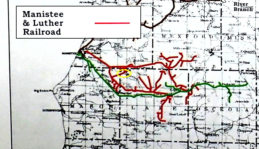
- M&L Manistee and Luther [ back to RAILROAD COMPANIES ]
- Railroad AD
- Narrow gauge.
- It actually started in East Lake (east of Manistee), so, the railroad never really went to Manistee.
- Tracks were frequently laid hastily which led to numerous accidents and fatalities.
- The original mainline to Luther incorporated on March 24, 1886. By 1887, it reached the Carey / Luther area. In 1898, this line had been abandoned to just west of its crossing with Railroad H.
- The new mainline to Hoxeyville put in service in 1897.
- M&NE Manistee & Northeastern [ back to RAILROAD COMPANIES ]
- Was organized in January 1887 at a meeting at the Buckley and Douglas Lumber Company in Manistee, Michigan. William Douglas and Edward Buckley were the principals behind the railroad. The M&NE was proposed to extend 75 miles from Manistee to Traverse City. The primary purpose of the railroad was to bring logs and lumber from northwestern lower Michigan to the big Buckley and Douglas saw mills in Manistee.
- Edward Buckley and William Douglas constructed and controlled the railroad company during nearly all its lifetime. They also operated one of the largest sawmills and salt plants in Manistee.
- Tracks were extended to Interlochen by June 1890.
- First made it to Traverse City in 1892.
- In 1910 the company was at its peak. It owned 355 miles of track, 15 steam locomotives, 2 snow plows, and numerous other pieces of equipment.
- Still at its peak in 1915, the M & NE carried 190,000 passengers.
- 1930 The company was leased to the PM.
- The company was turned over to the PM who took control of it in 1931.
- For many years, from 1892 to 1934, the railroad connected Traverse City to Manistee and numerous towns in between.
- Some parts of the M&NEs tracks were removed by October 1934 (maybe those to Traverse City).
- Some part of the line was used to haul freight until 1982.
- From the Platte River Junction one could get to Traverse City in two ways. 1) By taking the M&NE north to Solon then around and down to Traverse City, or 2) By taking the M&NE south to Interlochen then taking Railroad H to Traverse City.
- Besides the main line (Railroad I) there were many
branches. Starting at Manistee and working toward the northeast::
- The Onekama Branch (Railroad Z)
- The Bear Creek Branch started at Bear Creek then went eight miles southeast through Conger to Canfield's (lumber) Camp. It crossed Railroad H two miles south of Kaleva.
- The Manistee River Branch (Railroad J). Note that immediately before (SW of) this junction (and at an earlier time) was a junction for a 3-mile-long branch that went SE to Buckley & Douglas logging camps and operated between 1898 and 1901.
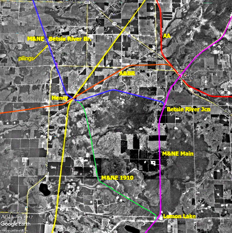
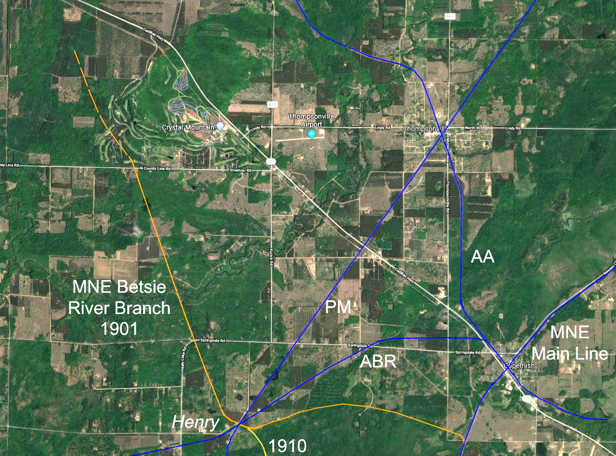
- The Betsie River Branch there are two versions: the earlier Railroad W and the later Railroad X.
- The Twin Lakes Branch that went from Twin Lakes Junction, which was just southeast of Twin Mountain and 1 or 2 miles southeast of Karlin, about 2.4 miles NNW to Twin Lake. Some claim it went as far as Grass Lake or maybe even Bendon.
- The Long Lake Branch, which was built in 1899, extended a mile in 1900,
and abandoned in 1901. Based on the map from A. G. Hudley, the route was a follows:
- From just south of US-31 and just west of M-137, the RR ran northeast, crossed Rogers Road roughly 2170 feet north of US-31,
- passed by Ellis Lake roughly 1100 feet on its northwest side,
- passed by a huge beaver pond roughly 450 feet on its northwest side,
- a little later turned east on the northeast side of Saunders Lake,
- went ESE to the southern tip of Bass Lake, at which point was a switch one part went ENE about 0.5 miles, another part went ESE about 0.5 miles.
- The Filer Branch, which started at Filers Switch at roughly 280 feet
northwest of the crossing of Mud Lake Road. (Not to be confused with Filer's Switch
on Railroad AC in Filer City down by Manistee.) This branch
went straight north following what is now Camp Trail, going past the dam for Lake
DuBonnet. According to the map from A. G. Hudley, along the way there were two spurs....
- Spur #1: About 2000 feet north of the dam was a switch for a spur going northeast it went about 4300 feet total along the northwest side of the lake then to its northern tip. (Most of that is an existing two-track.)
- Spur #2: About 200 feet later was another spur going to the northwest. (It's called Buckley Road and DNR Foot Trail on Google Maps its an existing two-track.) It went northwest about 5000 feet following what is now Buckley Road, then turned north, crossing Foot Trail after 3400 feet, then went north another 1400 feet to end south of Ransom Lake.
- The "central" part of this branch continued north past those two spurs then turned east a bit for a total length of a mile, following what's now called Lake DuBonnet Trail and ending on the north side of a former little lake.
- About the Filer Branch In 1897, a four mile long branch was built north from Filers Switch (three miles northwest of Interlochen), to a Buckley and Douglas camp. A year later, the branch was extended another two miles to tap new stands of timber, west and northwest of Lake DuBonnet. It was a short-lived adventure and was removed in 1900.
- The Platte River Branch (Railroad T), also called the Honor Branch on some maps.
- The Glen Arbor Branch, which was surveyed and mapped in 1894, but NEVER built. It would have run from Cedar, through Maple City and Burdickville, along the south side of Glen Lake, through the Glen Lake Narrows, along the east side of Glen Lake to Glen Arbor. Here is a map of the proposed route thanks to the Empire Museum. In fact, the M&NE had initially named their line north from Solon the "Glen Arbor and Omena Branch", but later they renamed it the "Provemont Branch". Because after the Panic of 1893, by the time they were able to build again, the TCL&M already went through Omena. Also, by then, Leelanau County was no longer a priority, so they "set their sites" on their other, more profitable, branches. Also, I assume much of the timber in the area was processed through D.H.Day's mill then taken via Railroad O to the docks on Lake Michigan at Glen Haven, thus not needing a logging railroad to Glen Arbor. As for passengers and freight into and out of Glen Arbor, being so close to the lake, I assume most of that was handled by boat, this lessening the need for a railroad here. (Thanks to M.B for doing the research on some of this and sharing it with me.)
- The Provemont Branch (Railroad Q)
- The Northport Branch (Railroad G). This railroad was not owned by the M&NE but was leased to them, so it's sometimes called their Northport Branch.
- M&NW Mancelona & Northwest [ back to RAILROAD COMPANIES ]
- Narrow gauge.
- During the heyday of the Antrim Iron Company, it owned its own railroad, which some say was this railroad. However, another, likely more reliable source proclaimed that the Antrim Iron Company was NOT associated with this railroad, but instead it used its own CS, a standard gauge line. That source also said this M&NW railroad was actually incorporated (on May 5, 1892) by the Mancelona Handle Company.
- The tracks went around eight miles to the NW of Mancelona (with a few branches along the way) and SW of Mancelona around five miles.
- The northwest part of this railroad was removed in 1902 and those rails were used on the southeastern section which began in 1902 and went over to the Big Twin Lake region.
- By March, 1907, the Mancelona Handle Company was out of business.
- MC Michigan Central [ back to RAILROAD COMPANIES ]
- Their main line went from Mackinaw City through Cheboygan, Gaylord, Frederic, Grayling, Roscommon, West Branch, Standish, Pinconning, Bay City, and beyond.
- Their East Jordan Branch ran from Frederic to East Jordan. That section was also the D&C and is covered in Railroad AA.
- Became a subsidiary of the NYC system in 1930.
- ME&W Michigan East and West [ back to RAILROAD COMPANIES ]
- Railroad AC
- Narrow gauge
- Until 1913 it was the M&GR
- A short time after 1913, the company constructed an extravagant depot located on Water Street near Spruce Street in Manistee.
- Soon after World War I the company failed and all of their assets were taken over by the PM which liquidated the operation.
- It was abandoned in 1918.
- MM&N Manistique, Marquette & Northern [ back to RAILROAD COMPANIES ]
- October 1903 initiated car ferry service between Northport and Manistique with ferry Manistique, Marquette & Northern No. 1.
- June 1904 The 75-mile route was abandoned
- (So says Michigan Railroad History.)
- MNR Michigan Northern Railway [ back to RAILROAD COMPANIES ]
- MR Marquette Rail [ back to RAILROAD COMPANIES ]
- The company was founded in November 2005 by Kevin Ruble, a nationally active railroad consultant, who purchased a CSX line running north from Grand Rapids to Ludington and Manistee.
- On 2/8/2012, RailAmerica, a national short-line operator, announced that it planned to purchase Marquette Rail for $40 million.
- RailAmerica and Marquette Rail were subsequently purchased by G&W.
- NYC New York Central [ back to RAILROAD COMPANIES ]
- OL&W Osceola, Lake, & Wexford
- Standard gauge.
- Opened in 1892.
- It was gone before 1897.
- Extending the Olga Branch of Railroad B, it went a
short ways from Olga to Hoxeyville.
- PC Penn Central [ back to RAILROAD COMPANIES ]
- PM Pere Marquette [ back to RAILROAD COMPANIES ]
- Railroad E, Railroad F, Railroad H, Railroad K, Railroad L, and Railroad S
- In 1900 this company was created by the merger of the C&WM, the DGR&W and the F&PM.
- Around 1924 when the PM took control of the M&NE, Railroad H from Baldwin to Traverse City was downgraded, and so from Baldwin Railroad K was used to Manistee, then Railroad I to Traverse City. One reason for the downgrading then abandonment was because the High Bridge north of Wellston and south of Brethren needed to be rebuilt.
- In 1947 it became part of the C&O
- Later became part of owned by Chessie System, CSX, and TSBY
- Through multiple consolidations and reorganizations, it provided local passenger service for 80 years and freight service for over 125 years.
- The Manistee Branch (Railroad K) built in 1881
from Wallhalla to Filer City continues to provide service to Manistee today (2018),
in an era when few railroads are left in northern Michigan.
- PRR Pennsylvania Railroad [ back to RAILROAD COMPANIES ]
- SOO Soo Line Railroad [ back to RAILROAD COMPANIES ]
- The primary United States railroad subsidiary of the Canadian Pacific Railway (CP) one of seven U.S. Class I railroads controlled through the Soo Line Corporation.
- Although it is named for the Minneapolis, St. Paul, and Sault Ste. Marie Railroad,
which was commonly known as the Soo Line after the phonetic spelling of Sault, it
was formed in 1961 by the consolidation of that company with two other CP subsidiaries
the Duluth, South Shore, and Atlantic Railroad, and the Wisconsin Central Railroad.
- TWC T. Wilce Co. Railroad [ back to RAILROAD COMPANIES ]
- Railroad U
- The original name of the E&SE, which it become known as in 1900.
- They originally built the railroad from Empire to Empire Junction as a logging
railroad to supply their mill with raw logs.
- TCL&M Traverse City, Leelanau, and Manistique
[
back to RAILROAD
COMPANIES ]
- Railroad G
- Was incorporated in 1901 to build a line from Traverse City to Northport in order to support a carferry service to Manistique in Michigans Upper Peninsula.
- This line was a project of the GR&I and completed a connection from Northport to the main north-south line (Railroad C) at Walton Junction via the TCR (Railroad D).
- Existed in 1914, we know for sure.
- Was later bought by the LTC.
- TCR Traverse City Railroad Company [ back to RAILROAD COMPANIES ]
- Railroad D
- Was built in 1872
- Sold to the GR&I in 1917
- TSBY Tuscola and Saginaw Bay Railway [ back to RAILROAD COMPANIES ]
- Became the GLC
- Became the GLC
- W&BV Watervale & Blaine Valley [ back to RAILROAD COMPANIES ]
- Railroad V
- It was initially planned to connect to Railroad H at Thompsonville, but it never made it.
- Opened sometime after 1894.
- Standard gauge
- Built by the Watervale Lumber Company
- This was simlpy a logging railroad to a mill and dock at Lake Michigan.
- It is said to have lasted only about 15 years (???) before the owner went bankrupt.
| V. Towns with Railroads Involved |
Railroad Companies |
Notes:
- A few of the "towns" below were just stops or stations, but they may have been a community or settlement.
- There were no railroads at the following towns:
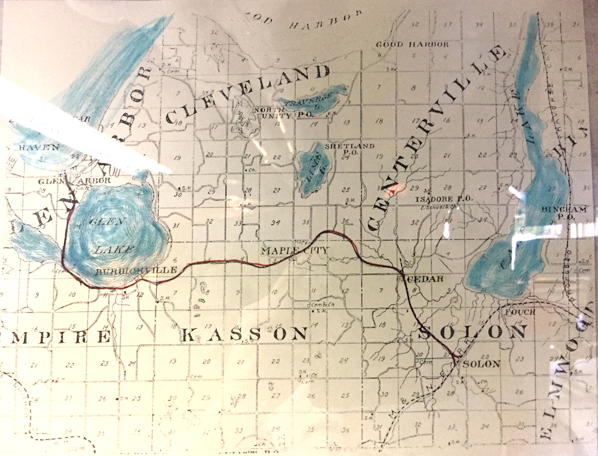
- Maple City, Burdickville, and Glen Arbor (ignoring the very short and short-lived GALC) but there was the proposed but never built Glen Arbor Branch of the M&NE through these locations.
- Leland and yet Leland was connected to the railroad at Provemont (Lake Leelanau) via steamers crossing Lake Leelanau
Jump to a starting letter...
| A B C D E F G H I J K L M N O P R S T W Y |
| Acme | Railroad C | |
| Alba | Railroad C + Railroad AA = crossing | |
| Alden | Railroad E | |
| Antrim | Railroad C + CS = junction | |
| Arcadia | Railroad M = end point | |
| Ashton | Railroad B | |
| Baldwin | Railroad H + Railroad L = diamond The PM also goes east through Reed City The PM also goes south through Bitely and Brohman to White Cloud |
|
| Barker Creek | Railroad C | |
| Bay View | Just ENE of Petoskey, junction of Railroad C and Railroad E. | |
| Bear Creek | Railroad I This was community or station southwest of Kaleva. There was a very short branch from here called the Bear Creek Branch. |
|
| Bear Lake | Railroad R | |
| Bellaire | Railroad E + Railroad Y = junction | |
| Bendon | Railroad H It was also the end of the line of the Twin Lakes Branch of Railroad I |
|
| Benzonia | Railroad A The RR skirted the east border down by Case Road |
|
| Beulah | Railroad A The town was originally called Crystal City and Beulah Resort At the depot here, there was a parallel but not-connected "siding" that was CLC. |
|
| Big Rapids | Railroad B | |
| Boon | Railroad A | |
| Boyne City | BCG&A | |
| Boyne Falls | Railroad C Also, a branch of the BCG&A came here from Boyne City. Also, the BF&NE started here. |
|
| Brethren | Railroad H | |
| Buckley | Railroad J The town was originally called Wexford. |
|
| Burdickville | The proposed but never built Glen Arbor Branch of the M&NE | |
| Cadillac | Railroad A + Railroad B + Railroad C + Railroad AE Theres a stubby wye south of Wright Street, a junction just north of Wright Street, and another junction by downtown at Cass and Lake Streets. It was the start of the C&D. It was the Southwestern end of the C&NE. It was first called Clam Lake Village. |
|
| Carrieville | Railroad AC went through here. This was part of the old mainline (southern branch) of Railroad AD. This was the west end of the north fork of GR&Is Manistee Branch off of Railroad B. Originally called Copleys Mill Also known as Carey, Carrey, and Careyville Just east of Luther on Kings Highway |
|
| Cedar | Railroad Q The proposed but never built Glen Arbor Branch of the M&NE Originally called Cedar City |
|
| Central Lake | Railroad E | |
| Charlevoix | Railroad E | |
| Chief | Railroad I | |
| Clarion | Railroad C | |
| Collision | See Honor | |
| Copemish | Railroad A + Railroad I = 3/4
of a full diamond Also, Railroad M northwest of town = junction with Railroad A Plus Railroad W southwest of town = junction with Railroad I |
|
| Crystal City | See Beulah | |
| Custer | Railroad L | |
| Deward | Railroad AA A sawmill was erected adjacent to the mainline here, around which a village grew. Its name honors the originator and original owner of the railroad, D(avid) E. Ward. |
|
| Dublin | Railroad H + Railroad AD = crossing Was also called Florence |
|
| East Jordan | Railroad Y and Railroad AA (South
Arm) = NO crossing There may have been a branch going east on what is now C-48, the East Jordan Boyne City Hwy, over to Deer Lake. |
|
| East Lake | Railroad K and Railroad AD | |
| Edgewater | Railroad N | |
| Elberta | Railroad A + Railroad P = junction The car ferry here that carried railroad cars from here to Wisconsin. Was originally called South Frankfort. In 1899 there was a siding from Railroad A to a mill owned by the Crane Lumber Company which was in the Cabbage Shed/Betsie Bay Marina area. |
|
| Elk Rapids | Railroad F = end point | |
| Ellsworth | Railroad E | |
| Elmira | Railroad C and BCG&A = overhead crossing | |
| Empire | Railroad U = end point | |
| Falmouth | The end of the Falmouth Branch of GR&Is Missaukee Branch | |
| Fife Lake | Railroad C | |
| Filer City | Railroad K + Railroad AC | |
| Fountain | Railroad K | |
| Frankfort | Railroad P = end point | |
| Frederic | Railroad AA and MC main line | |
| Free Soil | Railroad K | |
| Glen Arbor | GALC and the proposed but never built Glen Arbor Branch of the M&NE | |
| Glen Garry | Railroad J | |
| Glen Haven | Railroad O | |
| Grass Lake area
(Benzie County) |
Railroad H + Railroad S = junction | |
| Grawn | Railroad H | |
| Grayling | Railroad J and the MC (its main line)
= junction There was also a branch of the MC going to the northeast to Lovells, then split and went to Lewiston and Johannesburg. |
|
| Grielickville | Railroad I | |
| Harbor Springs | The end of the Harbor Springs Branch off of Railroad
C Originally called Little Traverse |
|
| Harrietta | Railroad A | |
| Hatchs Crossing | Railroad G + Railroad I = junction | |
| Henry | Railroad H + Railroad M + Railroad W / Railroad X = crossing | |
| High Bridge | Railroad H | |
| Honor | Railroad S + Railroad T = a possible
junction Originally Honor was called Collision. (Collision Creek runs from north to south on Honor's east side.) |
|
| Hoxeyville | Railroad AD and the western end of the OL&W. | |
| Interlochen | Railroad H + Railroad I = crossing | |
| Irons | Railroad H | |
| Isadore | Railroad Q | |
| Jacktown | Railroad U Now a ghost town on Oviatt Road |
|
| Jennings | The end of the Jennings Branch of GR&Is Missaukee
Branch. The beginning of the J&NE. It was known as Mitchell by the GR&I and was called Missaukee on some old maps. |
|
| Kaleva | Railroad H + Railroad I = crossing
with one wye Also, northeast of town, Railroad J branches off of Railroad I heading east. Originally called Manistee Crossing. |
|
| Kalkaska | Railroad C + Railroad AB = crossing | |
| Karlin | Railroad I | |
| Kingsley | Railroad D | |
| Lake Ann | Railroad I South of Lake Ann a few miles and just west of Lake Ann Road was the Platte River Junction where Railroad T went west through Honor to the Empire Junction. |
|
| Lake City | The northern end of the Lake City Branch of GR&Is Missaukee
Branch. The northeastern end of the C&NE. Originally known as the village of Muskrat Lake. |
|
| Lake Leelanau | Railroad Q = end point Originally called Provemont |
|
| Leetsville | It's now just a region north of Kalkaska, but at one time it was a stop on Railroad C. | |
| Lemon Lake | Railroad I + Railroad X = junction | |
| LeRoy | Railroad B | |
| Ludington | Railroad L and the LN The car ferry here used to cary railroad cars from here to Wisconson |
|
| Luther | Railroad AC + GR&Is north fork
of the Manistee Branch off of Railroad B = crossing Also: This was part of the old mainline (southern branch) of Railroad AD. |
|
| Mancelona | Railroad C | |
| Manistee | Railroad I + Railroad K + Railroad AC | |
| Manton | Railroad C | |
| Maple City | The proposed but never built Glen Arbor Branch of the M&NE | |
| Marilla | Railroad J | |
| Marion | Railroad A + Railroad AC = junction | |
| Mayfield | Railroad D | |
| Mesick | Railroad A Plus an overpass west of town: Railroad A crossing over Railroad J |
|
| Nessen City | Railroad I | |
| Northport | Railroad G There was a ferry from here to Manistique |
|
| Norwalk | Railroad I | |
| Oakhill | Railroad K + Railroad AC | |
| Olga | Originally called Alyn, this was western end of the Olga Branch of Railroad B and the eastern end of the OL&W. | |
| Omena | Railroad G | |
| Onekama | Railroad Z | |
| Peacock | Railroad H + Railroad AC = crossing | |
| Peshawbestown | Railroad G | |
| Petoskey | Railroad C + Railroad E = junction | |
| Phelps | Railroad E | |
| Pierport | Railroad R It was called Turnersport before 1871 |
|
| Provemont | See Lake Leenanau | |
| Rapid City | Railroad E + Railroad AB = junction | |
| Reed City | Railroad B (going north/south) + PM (going east/west) = crossing | |
| Sauble | Railroad AC | |
| Scottville | Railroad L | |
| Sharon | Railroad J + Railroad AB = crossing
NNW of town a ways Also, Railroad AB + LSSL = crossing |
|
| Smeltzer | Railroad V | |
| Solon | Railroad I + Railroad Q = junction | |
| South Boardman | Railroad C | |
| South Arm | Railroad AA It was just west of East Jordon on the shore of the southern tip of Lake Charlevoix. In 1905 merged with East Jordan. |
|
| South Frankfort | See Elberta | |
| Stratford | Railroad AB | |
| Stronach | Railroad K | |
| Suttons Bay | Railroad G | |
| Thompsonville | Railroad A + Railroad H = crossing | |
| Traverse City | Railroad D + Railroad E + Railroad H + Railroad I | |
| Turnersport | See Pierport | |
| Tustin | Railroad B + Railroad AC = crossing | |
| Twin Lake area
(Benzie County) |
End of the Twin Lake Branch from Twin Mountain off of Railroad I | |
| Twin Mountain | Railroad I = a stop somewhere between Nessen City and Karlin where there was a junction with the Twin Lake Branch | |
| Walhalla | Railroad K + Railroad L = wye. AKA Manistee Junction. | |
| Wallin | Railroad H Also, southwest of Wallin there was junction for the short the Weldon Lumber Company Branch going northwest to West End. The area was called Wallen on some early maps. |
|
| Walloon Lake | Railroad C | |
| Walton | Railroad C + Railroad D + Railroad J There is a wye (Walton Junction) just to the north of town Railroad C + Railroad D |
|
| Watervale | Railroad V | |
| Wellston | Railroad H | |
| Williamsburg | Railroad E + Railroad F = junction The tracks end here (2018) for Railroad E |
|
| Yuma | Railroad A The tracks end here (2018) |
| VI. Physical Railroads |
Railroad Companies |
Notes:
- The letter designation for each railroad is arbitrary and for use only in this document.
- The railroad companies listed in the title were the builders and/or primary users of the railroad back in the day.
- Route some routes are fairly easy to follow via satellite view, such as on Google Maps, Google Earth, or similar.
- Stations or stops involved:
- Stop 1 <-> Stop 2: The <-> symbol indicates these two stops may be the same, or they may be separate and are possibly be in the wrong order.
- Stations and/or stops were added or removed over time by a railroad company on a specific route.
- Sometimes just the towns, communities, or settlements that the railroad passed through are given.
A.
Railroad A Ann Arbor to Elberta AA B.
Railroad B Cadillac to Grand Rapids GR&Is Mackinaw Branch, part 1 C.
Railroad C Cadillac to Mackinaw City GR&Is Mackinaw Branch, part 2 D.
Railroad D Walton to Traverse City TCR, GR&I, etc. E.
Railroad E Traverse City to Bay View PM main line, part 2 F.
Railroad F Williamsburg to Elk Rapids PMs Elk Rapids Branch G.
Railroad G Hatchs Crossing to Northport LTC, TCL&M, LSR H.
Railroad H Traverse City to Baldwin PM Main Line, part 1 I.
Railroad I Manistee to Traverse City M&NEs main line J.
Railroad J Kaleva to Grayling M&NEs Manistee River Branch K.
Railroad K Filer City to Walhalla PM's Manistee Branch L.
Railroad L Baldwin to Ludington PM M.
Railroad M Arcadia to Copemish A&BR N.
Railroad N Edgewater to Lake Michigan Little & Son Tramway Logging O.
Railroad O Days Mill Pond to Glen Haven Logging P.
Railroad P Elberta to Frankfort AA's Frankfort Branch Q.
Railroad Q Solon to Provemont (Lake Leelanau) M&NEs Provemont Branch R.
Railroad R Pierport to Bear Lake and beyond BL&E S.
Railroad S Clary to Honor PMs Honor (or Turtle Lake) Branch T.
Railroad T Platte River Junction to Empire Junction M&NEs Platte River Branch U.
Railroad U Empire and Southeast E&SE V.
Railroad V Smeltzer to Lake Michigan west of Watervale Watervale & Blaine Valley Logging W.
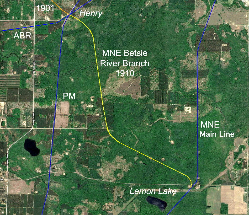
Railroad W Copemish through Henry to the Betsie River M&NEs Betsie River Branch, 1901 X.
Railroad X Lemon Lake to Henry M&NEs Betsie River Branch, 1910 Y.
Railroad Y East Jordan to Bellaire EJ&S Z.
Railroad Z Onekama Junction to Onekama M&NEs Onekama Branch AA.
Railroad AA Frederic to East Jordan MCs East Jordan Branch AB.
Railroad AB Rapid City to Stratford GRK&SE AC.
Railroad AC Manistee to Marion M&GR/ME&W AD.
Railroad AD East Lake to Luther / Hoxeyville M&L AE.
Railroad AE Cadillac to Hoxeyville / Meauwataka Lake